Login
Register
N51
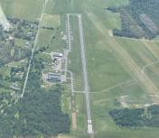
Solberg/Hunterdon Airport
Official FAA Data Effective 2026-02-19 0901Z
VFR Chart of N51
Sectional Charts at SkyVector.com
IFR Chart of N51
Enroute Charts at SkyVector.com
Location Information for N51
Coordinates: N40°34.97' / W74°44.20'Located 01 miles NW of Readington, New Jersey on 744 acres of land. View all Airports in New Jersey.
Estimated Elevation is 189 feet MSL.
Operations Data
|
|
Airport Communications
| NEWARK APPROACH: | 132.8 379.9 |
|---|---|
| NEWARK DEPARTURE: | 132.8 379.9 |
| CTAF: | 122.800 |
| WILKES-BARRE STAR: | 127.6 379.9 |
| UNICOM: | 122.800 |
| ASOS at SMQ (4.0 NE): | 120.6 908-722-2139 |
| AWOS-3 at N40 (11.5 W): | 121.725 |
| ATIS at TTN (18.7 S): | 126.775 |
Nearby Navigation Aids
|
| ||||||||||||||||||||||||||||||||||||||||||||||||||||||||||||
Runway 04/22
| Dimensions: | 5598 x 50 feet / 1706 x 15 meters | |
|---|---|---|
| Surface: | Asphalt-Turf RWY 04 TURF PORTION POOR AND UNUSBL. CENTER ASPH PORTION EXCELLENT. RWY 22 TURF PORTION POOR AND UNUSBL. | |
| Edge Lighting: | Medium Intensity RWY 04/22 MIRL ON PAVED 3735 FT BY 50 FT PORTION OF RWY. | |
| Runway 04 | Runway 22 | |
| Coordinates: | N40°34.45' / W74°44.43' | N40°35.25' / W74°43.83' |
| Elevation: | 179.8 | 153.0 |
| Traffic Pattern: | Left | Left |
| Runway Heading: | 29° True | 209° True |
| Displaced Threshold: | 544 Feet DSPLCD THLD 544 FT TURF 180 FT WIDE. |
1319 Feet DSPLCD THLD 1319 FT TURF 180 FT WIDE. |
| Markings: | Basic in good condition. | Non-Precision Instrument in good condition. |
| Glide Slope Indicator | P2L (3.00° Glide Path Angle) | P2L (3.00° Glide Path Angle) |
| REIL: | Yes | Yes |
| Obstacles: | 66 ft Tree 1655 ft from runway, 150 ft right of center | |
Runway 13/31
| Dimensions: | 3444 x 200 feet / 1050 x 61 meters | |
|---|---|---|
| Surface: | Turf in Good Condition | |
| Runway 13 | Runway 31 | |
| Coordinates: | N40°35.32' / W74°44.53' | N40°35.04' / W74°43.89' |
| Elevation: | 186.9 | 152.1 |
| Traffic Pattern: | Left | Left |
| Runway Heading: | 119° True | 299° True |
| Markings: | in good condition. | in good condition. |
| Obstacles: | 40 ft Tree 108 ft from runway, 99 ft left of center | 44 ft Trees 48 ft from runway |
Runway 10/28
| Dimensions: | 2010 x 100 feet / 613 x 30 meters | |
|---|---|---|
| Surface: | Turf in Fair Condition NOTICEABLE BUMP WHERE RWY CROSSES GRVL APCH ROAD TO VORTAC. | |
| Runway 10 | Runway 28 | |
| Coordinates: | N40°34.91' / W74°44.60' | N40°34.96' / W74°44.18' |
| Elevation: | 186.2 | 178.0 |
| Runway Heading: | 81° True | 261° True |
| Markings: | in poor condition. | in poor condition. |
| Obstacles: | 58 ft Trees 602 ft from runway, 81 ft right of center | |
Services Available
| Fuel: | 100LL (blue), Jet-A |
|---|---|
| Transient Storage: | Hangars,Tiedowns |
| Airframe Repair: | MAJOR |
| Engine Repair: | MAJOR |
| Bottled Oxygen: | NONE |
| Bulk Oxygen: | LOW |
| Other Services: | PILOT INSTRUCTION,AIRCRAFT RENTAL |
Ownership Information
| Ownership: | Privately Owned | |
|---|---|---|
| Owner: | SOLBERG AVIATION COMPANY | |
| 39 THOR SOLBERG ROAD | ||
| WHITEHOUSE STATION, NJ 08889 | ||
| 908-534-4000 | ||
| Manager: | SUZANNE SOLBERG NAGLE | CO-MGRS THOR SOLBERG III AND LORRAINE SOLBERG. |
| 39 THOR SOLBERG ROAD | ||
| WHITEHOUSE STATION, NJ 08889 | ||
| 908-534-4000 | ||
Other Remarks
- HEL FLY FIXED WING TFC PAT AND ALT.
- NO INTXN TKOF ON RWY 04/22.
- NO TGL ALL RWYS.
- ALL RWYS DEPT STRAIGHT OUT TO 1200 FT MSL BEFORE TURNING.
- BLIMP AND HOT AIR BALLOON ACTIVITY ON AND INVOF ARPT SPRING THRU FALL.
- GCO AVBL ON FREQ 121.725. IF UNABLE, CTC NEWARK APCH AT 800-645-3206.
- DEER ON AND INVOF ARPT.
- TKOFS & LNDGS PROHIBITED ON RWY 13/31 & RWY 10/28 WHEN ACFT ARE OPERNG ON RWY 4/22.
- CTC OPS, 908-534-4000, PRIOR TO OPERATING ON RWY 10/28.
- RWY 04 & RWY 22 TURF PTN POOR.
- ACTVT REIL RWY 04 & 22; MIRL RWY 04/22 - CTAF. PAPI RWY 04 & 22 OPR CONSLY.
Weather Minimums
Standard Terminal Arrival (STAR) Charts
Instrument Approach Procedure (IAP) Charts
Nearby Airports with Instrument Procedures
| ID | Name | Heading / Distance | ||
|---|---|---|---|---|
 |
KSMQ | Somerset Airport | 049° | 4.0 |
 |
47N | Central Jersey Regional Airport | 118° | 7.2 |
 |
N40 | Sky Manor Airport | 264° | 11.1 |
 |
39N | Princeton Airport | 162° | 11.6 |
 |
N85 | Alexandria Airport | 271° | 12.9 |
 |
KTTN | Trenton Mercer Airport | 190° | 18.7 |
 |
KMMU | Morristown Municipal Airport | 048° | 19.6 |
 |
KLDJ | Linden Airport | 084° | 22.6 |
 |
N87 | Trenton-Robbinsville Airport | 164° | 23.0 |
 |
KDYL | Doylestown Airport | 229° | 23.2 |
 |
3N6 | Old Bridge Airport | 130° | 23.4 |
 |
N43 | Braden Airpark Airport | 292° | 25.0 |


Comments
Automated Weather available
Automated weather is accessible via radio on 122.8 (CTAF) by clicking three times, or by visiting www.digiwx-n51.com .
Airport website: www.solbergairport.com