Login
Register
NDY
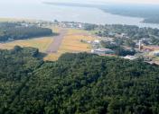
Dahlgren Nsf Airport
Official FAA Data Effective 2026-01-22 0901Z
VFR Chart of KNDY
Sectional Charts at SkyVector.com
IFR Chart of KNDY
Enroute Charts at SkyVector.com
Location Information for KNDY
Coordinates: N38°19.97' / W77°2.22'Located 00 miles E of Dahlgren, Virginia. View all Airports in Virginia.
Estimated Elevation is 18 feet MSL.
Operations Data
|
|
Airport Communications
| CTAF: | 126.200 |
|---|---|
| ATIS at NYG (16.3 NW): | 263.15 |
| AWOS-3 at EZF (19.8 W): | 128.125 540-372-6794 |
| AWOS-3 at RMN (20.1 W): | 126.325 540-657-8283 |
Nearby Navigation Aids
|
| ||||||||||||||||||||||||||||||||||||||||||||||||||||||||||||
Runway 16/34
CLSD. | ||
| Dimensions: | 4191 x 150 feet / 1277 x 46 meters | |
|---|---|---|
| Surface: | Asphalt | |
| Weight Limits: | S-35, D-85, ST-92 | |
| Edge Lighting: | Low Intensity | |
| Runway 16 | Runway 34 | |
| Coordinates: | N38°20.27' / W77°2.45' | N38°19.68' / W77°1.99' |
| Elevation: | 17.9 | 16.0 |
| Traffic Pattern: | Right | |
| Runway Heading: | 148° True | 328° True |
| Glide Slope Indicator | P2L | P2L |
| Approach Lights: | ODALS Omnidirectional Approach Lighting System | |
| REIL: | Yes | |
Ownership Information
| Ownership: | Owned by the Navy | |
|---|---|---|
| Owner: | US NAVY | |
| OCEANOGRAPHIC OFC - CODE 3142 | ||
| WASHINGTON, DC 20373 | ||
| Manager: | ||
Other Remarks
- CAUTION: GUN TESTS CONDUCTED OVER RIVER TO SE IN R-6611A AND R-6613A. XPLOS DETONATIONS OVR LAND TO S IN R-6612. A 442 FT TWR IS LCTD 0.5 NM E.
- OPERATING HRS 1100-2000Z++ MON-FRI EXC HOL. CTC DAHLGREN AIR OPS ON CTAF 10 MIN PRIOR TO ARR FOR ADZYS.
- RSTD: PPR 48 HR ADVN NOTICE RQRD. NSF DAHLGREN AIR OPS C301-708-5896; AFT DUTY HR C540-850-2380. DAY VFR HELI USE ONLY. NO FUEL OR MAINT SVC AVBL.
- FOR CD CTC WASHINGTON CENTER C703-771-3587.
- AVBL ONLY DURING HRS OF OPERATION.
Nearby Airports with Instrument Procedures
| ID | Name | Heading / Distance | ||
|---|---|---|---|---|
 |
2W5 | Maryland Airport | 353° | 15.9 |
 |
KNYG | Quantico Mcaf (Turner Field) Airport | 309° | 16.3 |
 |
KEZF | Shannon Airport | 258° | 19.9 |
 |
KRMN | Stafford Regional Airport | 281° | 20.2 |
 |
2W6 | St Mary's County Regional Airport | 092° | 22.9 |
 |
KDAA | Davison AAF Airport | 343° | 23.9 |
 |
KVKX | Potomac Airfield Airport | 008° | 25.2 |
 |
KXSA | Tappahannock/Essex County Airport | 166° | 29.2 |
 |
KNHK | Patuxent River NAS (Trapnell Field) Airport | 095° | 29.7 |
 |
KADW | Joint Base Andrews Airport | 015° | 29.7 |
 |
KDCA | Ronald Reagan Washington Ntl Airport | 359° | 31.1 |
 |
KHEF | Manassas Regional/Harry P Davis Field Airport | 316° | 32.4 |


