Login
Register


NE12
Center Creek Field Airport
Official FAA Data Effective 2026-02-19 0901Z
VFR Chart of NE12
Sectional Charts at SkyVector.com
IFR Chart of NE12
Enroute Charts at SkyVector.com
Location Information for NE12
Coordinates: N40°5.91' / W98°58.66'Located 01 miles W of Franklin, Nebraska. View all Airports in Nebraska.
Elevation is 1870 feet MSL.
Operations Data
|
|
Airport Communications
| AWOS-3PT at K82 (21.9 S): | 118.450 785-282-8326 |
|---|---|
| AWOS-3 at HDE (26.7 NW): | 121.325 308-995-6433 |
| AWOS-3PT at PHG (26.9 SW): | 119.125 785-543-8960 |
Nearby Navigation Aids
|
| ||||||||||||||||||||||||||||||||||||||||||||||||||||||||||||


Runway 04/22
| Dimensions: | 1238 x 40 feet / 377 x 12 meters | |
|---|---|---|
| Surface: | Turf in Good Condition | |
| Runway 04 | Runway 22 | |
| Coordinates: | N40°5.84' / W98°58.76' | N40°5.98' / W98°58.57' |
| Elevation: | 1870.0 | 1860.0 |
Ownership Information
| Ownership: | Privately Owned | |
|---|---|---|
| Owner: | KENT INGRAM | |
| 775 31 RD | ||
| FRANKLIN, NE 68939 | ||
| 308-991-2037 | ||
| Manager: | KENT INGRAM | |
| 775 31 RD | ||
| FRANKLIN, NE 68939 | ||
| 308-991-2037 | ||
Other Remarks
- FOR CD CTC MINNEAPOLIS ARTCC AT 651-463-5588.
Nearby Airports with Instrument Procedures
| ID | Name | Heading / Distance | ||
|---|---|---|---|---|
 |
4D9 | Alma Municipal Airport | 272° | 17.0 |
|
7V7 | Red Cloud Municipal Airport | 092° | 20.1 |
|
K82 | Smith Center Municipal Airport | 157° | 21.8 |
|
0V3 | Pioneer Village Field Airport | 003° | 25.0 |
|
KHDE | Brewster Field Airport | 322° | 26.8 |
|
KPHG | Phillipsburg Municipal Airport | 215° | 26.8 |
|
KEAR | Kearney Regional Airport | 357° | 37.7 |
|
KHSI | Hastings Municipal Airport | 039° | 39.5 |
|
12K | Superior Municipal Airport | 093° | 42.3 |
|
KNRN | Norton Municipal Airport | 250° | 44.8 |
|
KRCP | Rooks County Regional Airport | 198° | 47.6 |
|
08K | Harvard State Airport | 050° | 52.9 |
Airport Images
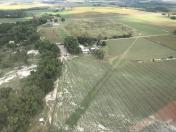
By: btracy62


