Login
Register


NHU
Norfolk Ns Airport
Official FAA Data Effective 2026-02-19 0901Z
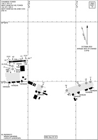
KNHU Airport Diagram
VFR Chart of KNHU
Sectional Charts at SkyVector.com
IFR Chart of KNHU
Enroute Charts at SkyVector.com
Location Information for KNHU
Coordinates: N36°57.34' / W76°18.23'Located 07 miles N of Norfolk, Virginia. View all Airports in Virginia.
Estimated Elevation is 10 feet MSL.
Operations Data
|
|
Airport Communications
| ATIS at NGU (1.3 SE): | 118.425 |
|---|---|
| ATIS at ORF (6.1 SE): | 127.15 |
| ASOS at ORF (6.7 SE): | 276-200-0952 |
Nearby Navigation Aids
|
| ||||||||||||||||||||||||||||||||||||||||||||||||||||||


Runway 09/27
| Dimensions: | 1705 x 150 feet / 520 x 46 meters | |
|---|---|---|
| Surface: | Asphalt in Excellent Condition | |
| Runway 09 | Runway 27 | |
| Coordinates: | N36°57.33' / W76°18.40' | N36°57.35' / W76°18.05' |
| Elevation: | 8.8 | 9.1 |
| Runway Heading: | 86° True | 266° True |
Helipad H9
| Dimensions: | 120 x 120 feet / 37 x 37 meters | |
|---|---|---|
| Surface: | Concrete in Excellent Condition | |
| Coordinates: | N36°56.90' / W76°17.64' | N0°0.00' / E0°0.00' |
| Elevation: | 9.4 | |
Helipad H7
| Dimensions: | 120 x 120 feet / 37 x 37 meters | |
|---|---|---|
| Surface: | Concrete in Excellent Condition | |
| Coordinates: | N36°56.94' / W76°16.94' | N0°0.00' / E0°0.00' |
| Elevation: | 8.7 | |
Helipad H8
| Dimensions: | 120 x 120 feet / 37 x 37 meters | |
|---|---|---|
| Surface: | Concrete in Excellent Condition | |
| Coordinates: | N36°56.85' / W76°17.20' | N0°0.00' / E0°0.00' |
| Elevation: | 9.0 | |
Helipad H3
| Dimensions: | 120 x 120 feet / 37 x 37 meters | |
|---|---|---|
| Surface: | Concrete in Excellent Condition | |
| Coordinates: | N36°57.26' / W76°18.33' | N0°0.00' / E0°0.00' |
| Elevation: | 9.4 | |
Helipad H4
| Dimensions: | 120 x 120 feet / 37 x 37 meters | |
|---|---|---|
| Surface: | Concrete in Excellent Condition | |
| Coordinates: | N36°57.21' / W76°18.32' | N0°0.00' / E0°0.00' |
| Elevation: | 8.2 | |
Helipad H5
| Dimensions: | 120 x 120 feet / 37 x 37 meters | |
|---|---|---|
| Surface: | Concrete in Excellent Condition | |
| Coordinates: | N36°57.01' / W76°16.67' | N0°0.00' / E0°0.00' |
| Elevation: | 8.7 | |
Helipad H6
| Dimensions: | 120 x 120 feet / 37 x 37 meters | |
|---|---|---|
| Surface: | Concrete in Excellent Condition | |
| Coordinates: | N36°56.98' / W76°16.81' | N0°0.00' / E0°0.00' |
| Elevation: | 8.9 | |
Helipad H2
| Dimensions: | 75 x 75 feet / 23 x 23 meters | |
|---|---|---|
| Surface: | Asphalt in Excellent Condition | |
| Coordinates: | N36°57.33' / W76°18.32' | N0°0.00' / E0°0.00' |
| Elevation: | 8.8 | |
Helipad H1
| Dimensions: | 75 x 75 feet / 23 x 23 meters | |
|---|---|---|
| Surface: | Asphalt in Excellent Condition | |
| Coordinates: | N36°57.35' / W76°18.10' | N0°0.00' / E0°0.00' |
| Elevation: | 9.1 | |
Ownership Information
| Ownership: | Owned by the Navy | |
|---|---|---|
| Owner: | NAVAL STATION NORFOLK | |
| 1530 GILBERT ST STE 2000 | ||
| NORFOLK, VA 23511 | ||
| 757-322-2302 | ||
| Manager: | SHANE DUDLEY | |
| 8610 AIR CARGO ROAD | ||
| NORFOLK, VA 23511 | ||
| 757-322-3420 | ||
Weather Minimums
Instrument Approach Procedure (IAP) Charts


Departure Procedure (DP) Charts

Nearby Airports with Instrument Procedures
| ID | Name | Heading / Distance | ||
|---|---|---|---|---|
 |
KNGU | Norfolk Ns (Chambers Field) Airport | 147° | 1.3 |
|
KORF | Norfolk International Airport | 126° | 6.1 |
|
KLFI | Langley AFB Airport | 340° | 8.1 |
|
KPVG | Hampton Roads Exec Airport | 214° | 12.7 |
|
KPHF | Newport News/Williamsburg International Airport | 319° | 13.9 |
|
KNTU | Oceana NAS (Apollo Soucek Field) Airport | 121° | 15.3 |
|
KCPK | Chesapeake Regional Airport | 182° | 17.4 |
|
KFAF | Felker AAF Airport | 305° | 18.1 |
|
KSFQ | Suffolk Exec Airport | 221° | 21.7 |
|
KJGG | Waltrip Williamsburg Exec Airport Airport | 310° | 26.1 |
|
KFKN | Franklin Regional Airport | 242° | 32.6 |
|
KAKQ | Wakefield Municipal Airport | 273° | 33.6 |
Airport Images
Do you have a recent image of this airport? Upload it here!


