Login
Register


AKQ
Wakefield Municipal Airport
Official FAA Data Effective 2026-01-22 0901Z
Chart Supplement

VFR Chart of KAKQ
Sectional Charts at SkyVector.com
IFR Chart of KAKQ
Enroute Charts at SkyVector.com
Location Information for KAKQ
Coordinates: N36°59.23' / W77°0.07'Located 02 miles NW of Wakefield, Virginia on 122 acres of land. View all Airports in Virginia.
Estimated Elevation is 111 feet MSL.
Operations Data
|
|
Airport Communications
| ASOS: | 128.325 Tel. 757-684-3011 |
|---|---|
| NORFOLK APPROACH: | 127.9 269.425 |
| NORFOLK DEPARTURE: | 127.9 269.425 |
| CTAF: | 122.800 |
| UNICOM: | 122.800 |
| AWOS-3PT at FKN (18.0 S): | 124.675 757-562-8765 |
| AWOS-3 at JGG (20.4 NE): | 120.625 757-220-8810 |
| ASOS at PHF (25.9 E): | 757-874-3682 |
Nearby Navigation Aids
|
| ||||||||||||||||||||||||||||||||||||||||||||||||||||||||||||


Runway 03/21
| Dimensions: | 4337 x 75 feet / 1322 x 23 meters | |
|---|---|---|
| Surface: | Asphalt in Fair Condition | |
| Weight Limits: | S-12 | |
| Edge Lighting: | Medium Intensity | |
| Runway 03 | Runway 21 | |
| Coordinates: | N36°58.89' / W77°0.20' | N36°59.57' / W76°59.94' |
| Elevation: | 107.4 | 111.4 |
| Traffic Pattern: | Left | Left |
| Runway Heading: | 17° True | 197° True |
| Displaced Threshold: | 298 Feet | 471 Feet |
| Markings: | Non-Precision Instrument in poor condition. | Non-Precision Instrument in poor condition. |
| Obstacles: | 28 ft Trees 201 ft from runway, 52 ft left of center CTLNG OBSTN EXCEEDS A 45 DEG SLP, CLNC SLP TO DSPLCD THLD 8:1. RD +15' 70' FM THR CROSSING END. |
62 ft Trees 1154 ft from runway, 34 ft right of center CLNC SLP TO DSPLCD THLD 22:1. ROAD +15 FT 70 FT FM RY END. |
Services Available
| Fuel: | 100LL (blue) |
|---|---|
| Transient Storage: | Hangars,Tiedowns |
| Airframe Repair: | NONE |
| Engine Repair: | NONE |
| Bottled Oxygen: | NONE |
| Bulk Oxygen: | NONE |
| Other Services: | CROP DUSTING SERVICES |
Ownership Information
| Ownership: | Publicly owned | |
|---|---|---|
| Owner: | TOWN OF WAKEFIELD | |
| P O BOX 550 | ||
| WAKEFIELD, VA 23888 | ||
| 757-899-2030 | ||
| Manager: | BRIAN LAINE | |
| P.O. BOX 550 | ||
| WAKEFIELD, VA 23888 | ||
| 757-899-0096 | ||
Other Remarks
- FOR CD CTC NORFOLK APCH AT 757-464-0757.
- RWY 03 MRKGS CVRD WITH ALGAE.
- RWY 21 MRKGS CVRD WITH ALGAE.
- 0LL 24 HR SELF SERVICE FUEL.
Weather Minimums

Standard Terminal Arrival (STAR) Charts
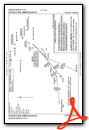
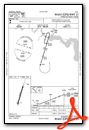
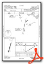
Instrument Approach Procedure (IAP) Charts
Nearby Airports with Instrument Procedures
| ID | Name | Heading / Distance | ||
|---|---|---|---|---|
 |
KFKN | Franklin Regional Airport | 164° | 17.8 |
|
KJGG | Waltrip Williamsburg Exec Airport Airport | 042° | 20.4 |
|
KFAF | Felker AAF Airport | 065° | 20.8 |
|
KPHF | Newport News/Williamsburg International Airport | 070° | 25.9 |
|
KSFQ | Suffolk Exec Airport | 133° | 26.6 |
|
KPTB | Tri Cities Exec/Dinwiddie County Airport | 296° | 27.0 |
|
KPVG | Hampton Roads Exec Airport | 114° | 29.2 |
|
KEMV | Emporia-Greensville Regional Airport | 232° | 29.4 |
|
KLFI | Langley AFB Airport | 079° | 31.3 |
|
W96 | New Kent County Airport | 349° | 31.5 |
|
KFYJ | Middle Peninsula Regional Airport | 019° | 34.0 |
|
KNGU | Norfolk Ns (Chambers Field) Airport | 094° | 34.4 |
Airport Images
Do you have a recent image of this airport? Upload it here!


Comments
Fuel
100LL $3.70 8/22/16. Pump is slow and hose reel needs some help, but it is cheap fuel.
Andrew C. Dirkes