Login
Register
NY02
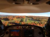
Mountain Top Airport
Official FAA Data Effective 2024-11-28 0901Z
VFR Chart of NY02
Sectional Charts at SkyVector.com
IFR Chart of NY02
Enroute Charts at SkyVector.com
Location Information for NY02
Coordinates: N42°29.27' / W74°46.75'Located 03 miles NE of Davenport, New York. View all Airports in New York.
Estimated Elevation is 1978 feet MSL.
Operations Data
|
|
Airport Communications
| UNICOM: | 122.800 |
|---|---|
| AWOS-3 at N66 (12.9 W): | 119.575 607-643-0253 |
| AWOS-3 at N23 (30.3 W): | 118.275 607-561-2333 |
| AWOS-3 at OIC (33.3 W): | 119.025 607-336-8583 |
Nearby Navigation Aids
|
| ||||||||||||||||||||||||||||||||||||||||||||||||||||||||||||
Runway 06/24
| Dimensions: | 2290 x 40 feet / 698 x 12 meters | |
|---|---|---|
| Surface: | Asphalt in Excellent Condition | |
| Runway 06 | Runway 24 | |
| Coordinates: | N42°29.15' / W74°46.95' | N42°29.38' / W74°46.55' |
| Elevation: | 1900.0 | 1978.0 |
| Traffic Pattern: | Left | Left |
| Runway Heading: | 51° True | 231° True |
| Obstacles: | ft Trees 500 ft from runway | ft Trees 130 ft from runway |
Services Available
| Fuel: | NONE |
|---|---|
| Transient Storage: | NONE |
| Airframe Repair: | NONE |
| Engine Repair: | NONE |
| Bottled Oxygen: | NONE |
| Bulk Oxygen: | NONE |
Ownership Information
| Ownership: | Privately Owned | |
|---|---|---|
| Owner: | GREGORY LUBINITSKY | |
| 396 ZIMMERMAN RD | ||
| HARPERSFIELD, NY 12093 | ||
| 917-957-0120 | ||
| Manager: | GREGORY LUBINITSKY | |
| 396 ZIMMERMAN RD | ||
| HARPERSFIELD, NY 12093 | ||
| 917-957-0120 | ||
Other Remarks
- ACTIVE RACETRACK CALL (917) 843-3831 0R 122.8 BEFORE LANDING.
- FOR CD CTC BOSTON ARTCC AT 603-879-6859.
Nearby Airports with Instrument Procedures
| ID | Name | Heading / Distance | ||
|---|---|---|---|---|
 |
N66 | Albert S Nader Regional Airport | 280° | 12.9 |
 |
N23 | Sidney Municipal Airport | 248° | 30.4 |
 |
KOIC | Lt Warren Eaton Airport | 278° | 33.4 |
 |
NY0 | Fulton County Airport | 032° | 36.5 |
 |
KVGC | Hamilton Municipal Airport | 301° | 40.7 |
 |
4B0 | South Albany Airport | 083° | 42.2 |
 |
KSCH | Schenectady County Airport | 059° | 43.5 |
 |
KALB | Albany International Airport | 069° | 46.0 |
 |
20N | Kingston-Ulster Airport | 129° | 47.2 |
 |
KMSV | Sullivan County International Airport | 180° | 47.2 |
 |
1B1 | Columbia County Airport | 103° | 49.0 |
 |
N89 | Joseph Y Resnick Airport | 158° | 48.9 |


