Login
Register


O02
Nervino Airport
Official FAA Data Effective 2026-02-19 0901Z
Chart Supplement

VFR Chart of O02
Sectional Charts at SkyVector.com
IFR Chart of O02
Enroute Charts at SkyVector.com
Location Information for O02
Coordinates: N39°49.11' / W120°21.17'Located 01 miles E of Beckwourth, California on 99 acres of land. View all Airports in California.
Surveyed Elevation is 4899 feet MSL.
Operations Data
|
|
Airport Communications
| AWOS-2: | 119.35 Tel. 530-832-6942 |
|---|---|
| NORCAL APPROACH: | 126.3 353.9 |
| NORCAL DEPARTURE: | 126.3 353.9 |
| UNICOM: | 122.800 |
| CTAF: | 122.800 |
| AWOS-3 at RTS (24.0 SE): | 135.175 775-677-0589 |
| AWOS-2 at 2O1 (28.1 W): | 135.600 530-283-6528 |
| AWOS-3 at AHC (28.4 N): | 118.825 530-827-4520 |
Nearby Navigation Aids
|
| ||||||||||||||||||||||||||||||||||||


Runway 08/26
| Dimensions: | 4651 x 75 feet / 1418 x 23 meters | |
|---|---|---|
| Surface: | Asphalt in Good Condition | |
| Weight Limits: | S-12 | |
| Edge Lighting: | Medium Intensity | |
| Runway 08 | Runway 26 | |
| Coordinates: | N39°49.11' / W120°21.67' | N39°49.11' / W120°20.67' |
| Elevation: | 4898.6 | 4891.1 |
| Traffic Pattern: | Right | Left |
| Runway Heading: | 90° True | 270° True |
| Markings: | Basic in good condition. | Basic in good condition. |
| Glide Slope Indicator | P2L (3.50° Glide Path Angle) | |
| Obstacles: | 15 ft Road 510 ft from runway | 3 ft Fence 270 ft from runway |
Services Available
| Fuel: | 100LL (blue), Jet-A |
|---|---|
| Transient Storage: | Tiedowns |
| Airframe Repair: | MAJOR |
| Engine Repair: | MAJOR |
| Bottled Oxygen: | NONE |
| Bulk Oxygen: | NONE |
| Other Services: | PILOT INSTRUCTION,AIRCRAFT RENTAL,AIRCRAFT SALES |
Ownership Information
| Ownership: | Publicly owned | |
|---|---|---|
| Owner: | PLUMAS COUNTY | |
| 198 ANDY'S WAY | ||
| QUINCY, CA 95971 | ||
| 530-283-6299 | ||
| Manager: | NICK COLLIN | |
| 198 ANDY'S WAY | ||
| QUINCY, CA 95971 | ||
| 530-283-6069 | FBO PHONE 530-616-0310. | |
Other Remarks
- FOR CD CTC NORCAL APCH AT 916-361-0596.
- COLD TEMPERATURE AIRPORT. ALTITUDE CORRECTION REQUIRED AT OR BELOW -13C.
- ACTVT MIRL RY 08/26 - CTAF.
Weather Minimums
Instrument Approach Procedure (IAP) Charts

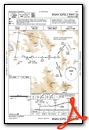
Nearby Airports with Instrument Procedures
| ID | Name | Heading / Distance | ||
|---|---|---|---|---|
 |
KRTS | Reno/Stead Airport | 112° | 23.8 |
|
KTRK | Truckee-Tahoe Airport | 161° | 31.5 |
|
KRNO | Reno/Tahoe International Airport | 125° | 33.2 |
|
KSVE | Susanville Municipal Airport | 343° | 34.9 |
|
KGOO | Nevada County Airport | 220° | 46.7 |
|
KCXP | Carson City Airport | 142° | 47.3 |
|
O05 | Rogers Field Airport | 304° | 49.5 |
|
KMEV | Minden-Tahoe Airport | 150° | 56.5 |
|
KSPZ | Silver Springs Airport | 115° | 56.8 |
|
KTVL | Lake Tahoe Airport | 163° | 57.9 |
|
KAUN | Auburn Municipal Airport | 213° | 61.9 |
|
KOVE | Oroville Municipal Airport | 251° | 62.1 |
Airport Images
Do you have a recent image of this airport? Upload it here!


Comments
Wrong phone number
Phone number is 530-832-6940, not 520 prefix
A Matthew atiyeh