Login
Register


OH23
Ohiohealth O'Bleness Hospital Heliport
Official FAA Data Effective 2025-12-25 0901Z
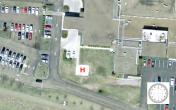
VFR Chart of OH23
Sectional Charts at SkyVector.com
IFR Chart of OH23
Enroute Charts at SkyVector.com
Location Information for OH23
Coordinates: N39°19.59' / W82°6.88'Located 00 miles W of Athens, Ohio. View all Airports in Ohio.
Estimated Elevation is 644 feet MSL.
Operations Data
|
|
Airport Communications
| HUNTINGTON APPROACH: | 120.95 |
|---|---|
| HUNTINGTON DEPARTURE: | 120.95 |
| CTAF: | 122.900 |
| AWOS-3 at UNI (8.7 SW): | 128.325 740-597-2687 |
| AWOS-3 at 3I2 (24.7 S): | 119.675 304-675-4618 |
| AWOS-2 at I18 (27.5 SE): | 121.3 304-273-3424 |
Nearby Navigation Aids
|
| ||||||||||||||||||||||||||||||||||||||||||||||||||||||||||||


Helipad H1
| Dimensions: | 30 x 30 feet / 9 x 9 meters | |
|---|---|---|
| Surface: | Concrete | |
| Coordinates: | N39°19.59' / W82°6.88' | N0°0.00' / E0°0.00' |
| Elevation: | 644.0 | |
Ownership Information
| Ownership: | Privately Owned | |
|---|---|---|
| Owner: | SHELTERING ARMS HOSPITAL | |
| 55 HOSPITAL DR | ||
| ATHENS, OH 45701-2302 | ||
| 740-593-5551 | ||
| Manager: | STEPHEN NOFTZ | |
| 55 HOSPITAL DR | ||
| ATHENS, OH 45701-2302 | ||
| 740-592-9459 | ||
Other Remarks
- FOR CD CTC HUNTINGTON ATCT AT 304-453-2490.
Nearby Airports with Instrument Procedures
| ID | Name | Heading / Distance | ||
|---|---|---|---|---|
 |
KUNI | Ohio University Airport | 217° | 8.7 |
|
I86 | Ed Newlon Field Airport | 350° | 22.2 |
|
3I2 | Mason County Airport | 178° | 24.7 |
|
I18 | Jackson County Airport | 149° | 27.5 |
|
KGAS | Gallia-Meigs Regional Airport | 184° | 29.6 |
|
KJRO | James A Rhodes Airport | 226° | 29.9 |
|
KPKB | Mid-Ohio Valley Regional Airport | 087° | 31.5 |
|
KLHQ | Fairfield County Airport | 315° | 36.0 |
|
KZZV | Zanesville Municipal Airport | 015° | 38.5 |
|
KEOP | Pike County Airport | 256° | 39.1 |
|
I10 | Noble County Airport | 043° | 39.1 |
|
KCYO | Pickaway County Memorial Airport | 286° | 41.9 |
Airport Images
By: DPfeiffer

By: DPfeiffer


