Login
Register


ONZ
Grosse Ile Municipal Airport
Official FAA Data Effective 2026-01-22 0901Z
Chart Supplement

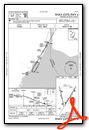
VFR Chart of KONZ
Sectional Charts at SkyVector.com
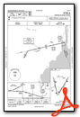
IFR Chart of KONZ
Enroute Charts at SkyVector.com
Location Information for KONZ
Coordinates: N42°5.94' / W83°9.69'Located 02 miles S of Detroit/Grosse Ile, Michigan on 607 acres of land. View all Airports in Michigan.
Surveyed Elevation is 590 feet MSL.
Operations Data
|
|
Airport Communications
| AWOS-3: | 119.675 Tel. 734-692-9686 |
|---|---|
| DETROIT APPROACH: | 134.3 284.0 |
| DETROIT DEPARTURE: | 134.3 284.0 |
| UNICOM: | 123.000 |
| CTAF: | 123.000 |
| D-ATIS at DTW (10.9 NW): | 118.125 ;DEP |
| ASOS at DTW (10.9 NW): | 231-202-2054 |
| AWOS-3 at TTF (15.5 SW): | 119.075 734-384-0259 |
Nearby Navigation Aids
|
| ||||||||||||||||||||||||||||||||||||||||||||||||||||||||||||


Runway 04/22
| Dimensions: | 4846 x 100 feet / 1477 x 30 meters | |
|---|---|---|
| Surface: | Asphalt in Good Condition | |
| Weight Limits: | S-66, D-83, ST-105 | |
| Edge Lighting: | Medium Intensity | |
| Runway 04 | Runway 22 | |
| Coordinates: | N42°5.60' / W83°9.74' | N42°6.29' / W83°9.20' |
| Elevation: | 576.8 | 589.3 |
| Traffic Pattern: | Right | Left |
| Runway Heading: | 30° True | 210° True |
| Displaced Threshold: | 428 Feet | |
| Markings: | Non-Precision Instrument in good condition. | Non-Precision Instrument in good condition. |
| Glide Slope Indicator | P4L (3.04° Glide Path Angle) | P4L (3.04° Glide Path Angle) |
| REIL: | Yes | Yes |
| Obstacles: | 37 ft Tree 790 ft from runway, 308 ft left of center | 65 ft Trees 1010 ft from runway, 344 ft left of center APCH RATIO 20:1 TO DTHR. |
Runway 17/35
| Dimensions: | 4424 x 75 feet / 1348 x 23 meters | |
|---|---|---|
| Surface: | Concrete in Poor Condition EXTSV PEELING & CRACKING - FOD HAZ. | |
| Weight Limits: | S-40, D-55, ST-90 | |
| Edge Lighting: | Medium Intensity | |
| Runway 17 | Runway 35 | |
| Coordinates: | N42°6.30' / W83°10.04' | N42°5.59' / W83°9.81' |
| Elevation: | 581.3 | 578.3 |
| Traffic Pattern: | Left | Right |
| Runway Heading: | 167° True | 347° True |
| Displaced Threshold: | 672 Feet | |
| Markings: | Basic in fair condition. | Basic in fair condition. |
| Glide Slope Indicator | P4L (3.00° Glide Path Angle) | P4L (3.00° Glide Path Angle) |
| Obstacles: | 80 ft Trees 1180 ft from runway, 40 ft right of center | |
Helipad H1
| Dimensions: | 25 x 25 feet / 8 x 8 meters | |
|---|---|---|
| Surface: | Concrete | |
| Coordinates: | N42°6.32' / W83°9.47' | N0°0.00' / E0°0.00' |
| Elevation: | 595.0 | |
Helipad H2
| Dimensions: | 25 x 25 feet / 8 x 8 meters | |
|---|---|---|
| Surface: | Concrete | |
| Coordinates: | N42°6.32' / W83°9.45' | N0°0.00' / E0°0.00' |
| Elevation: | 594.0 | |
Services Available
| Fuel: | 100LL (blue), Jet-A |
|---|---|
| Transient Storage: | Hangars,Tiedowns |
| Airframe Repair: | MAJOR |
| Engine Repair: | MAJOR |
| Bottled Oxygen: | NONE |
| Bulk Oxygen: | NONE |
| Other Services: | CHARTER SERVICE,PILOT INSTRUCTION,AIRCRAFT RENTAL |
Ownership Information
| Ownership: | Publicly owned | |
|---|---|---|
| Owner: | TOWNSHIP OF GROSSE ILE | |
| PO BOX 129, PO BOX 129 | ||
| GROSSE ILE, MI 48138 | ||
| 734-675-0155 | ||
| Manager: | JANEL MACNEE | |
| P.O. BOX 129, PO BOX 129 | ||
| GROSSE ILE, MI 48138 | ||
| 734-675-0155 | ||
Other Remarks
- BIRDS & DEER ON & INVOF ARPT.
- ULTRALIGHT & PWRD PRCHT ACT INVOF ARPT.
- FOR CD CTC DETROIT APCH AT 734-955-1404.
- ARPT CLSD TO ACR OPS GTR THAN 30 PAX SEATS EXC PPR CALL AMGR.
- ACTVT REIL RWY 04 & 22; PAPI RWY 04, 22, 17, & 35; MIRL RWY 04/22 & 17/35 - CTAF.
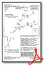
Weather Minimums

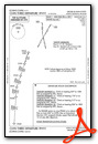
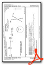
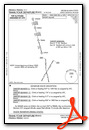
Standard Terminal Arrival (STAR) Charts
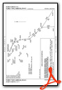
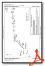
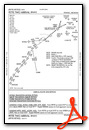

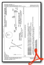
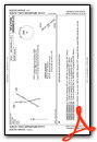
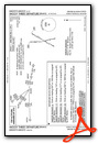
Instrument Approach Procedure (IAP) Charts

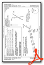
Departure Procedure (DP) Charts


Nearby Airports with Instrument Procedures
| ID | Name | Heading / Distance | ||
|---|---|---|---|---|
 |
KDTW | Detroit Metro Wayne County Airport | 308° | 10.9 |
|
CYQG | Windsor Airport | 040° | 14.0 |
|
KTTF | Custer Airport | 232° | 15.5 |
|
KYIP | Willow Run Airport | 297° | 18.6 |
|
1D2 | Canton-Plymouth-Mettetal Airport | 318° | 19.9 |
|
KDET | Coleman A Young Municipal Airport | 019° | 20.0 |
|
KVLL | Oakland/Troy Airport | 358° | 26.6 |
|
KARB | Ann Arbor Municipal Airport | 286° | 27.1 |
|
KDUH | Toledo Suburban Airport | 225° | 31.1 |
|
Y47 | Oakland Southwest Airport | 319° | 31.8 |
|
KMTC | Selfridge Angb Airport | 024° | 34.1 |
|
KTDZ | Toledo Exec Airport | 204° | 35.1 |
Airport Images

By: Geoffrey Thorpe


