Login
Register


OTM
Ottumwa Regional Airport
Official FAA Data Effective 2026-01-22 0901Z
Chart Supplement

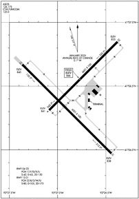
KOTM Airport Diagram
VFR Chart of KOTM
Sectional Charts at SkyVector.com
IFR Chart of KOTM
Enroute Charts at SkyVector.com
Location Information for KOTM
Coordinates: N41°6.43' / W92°26.83'Located 05 miles NW of Ottumwa, Iowa on 1600 acres of land. View all Airports in Iowa.
Surveyed Elevation is 845 feet MSL.
Operations Data
|
|
Airport Communications
| ASOS: | 124.175 Tel. 641-684-9164 |
|---|---|
| UNICOM: | 123.000 |
| CTAF: | 123.000 |
| AWOS-3 at OOA (7.5 N): | 118.625 641-933-4312 |
| AWOS-3 at FFL (21.4 E): | 132.025 641-472-4548 |
| AWOS-3 at PEA (28.4 NW): | 118.875 641-628-3459 |
- APCH/DEP SVC PRVDD BY CHICAGO ARTCC ON FREQS 118.15/335.575 (OTTUMWA RCAG).
Nearby Navigation Aids
|
| ||||||||||||||||||||||||||||||||||||||||||||||||


Runway 13/31
| Dimensions: | 6001 x 100 feet / 1829 x 30 meters | |
|---|---|---|
| Surface: | Concrete / Grooved in Excellent Condition | |
| Weight Limits: | 33 /R/D/W/U, S-80, D-105, ST-175 | |
| Edge Lighting: | High Intensity | |
| Runway 13 | Runway 31 | |
| Coordinates: | N41°6.67' / W92°27.37' | N41°5.97' / W92°26.44' |
| Elevation: | 840.0 | 838.4 |
| Traffic Pattern: | Left | Left |
| Runway Heading: | 135° True | 315° True |
| Markings: | Precision Instrument in good condition. | Precision Instrument in good condition. |
| Glide Slope Indicator | P4L (3.00° Glide Path Angle) | |
| Approach Lights: | MALSR 1,400 Foot Medium-intensity Approach Lighting System with runway alignment indicator lights. | |
| REIL: | Yes | |
Runway 04/22
| Dimensions: | 4601 x 100 feet / 1402 x 30 meters | |
|---|---|---|
| Surface: | Asphalt-Concrete in Good Condition | |
| Weight Limits: | 13 /F/D/X/U, S-42, D-65, ST-120 | |
| Edge Lighting: | High Intensity | |
| Runway 04 | Runway 22 | |
| Coordinates: | N41°6.31' / W92°27.09' | N41°6.85' / W92°26.38' |
| Elevation: | 841.4 | 832.7 |
| Traffic Pattern: | Left | Left |
| Runway Heading: | 45° True | 225° True |
| Markings: | Non-Precision Instrument in good condition. | Non-Precision Instrument in good condition. |
| Glide Slope Indicator | P2L (3.00° Glide Path Angle) | P2L (3.00° Glide Path Angle) |
| REIL: | Yes | Yes |
Services Available
| Fuel: | 100LL (blue), Jet-A |
|---|---|
| Transient Storage: | Hangars,Tiedowns |
| Airframe Repair: | MAJOR |
| Engine Repair: | MAJOR |
| Bottled Oxygen: | NONE |
| Bulk Oxygen: | HIGH/LOW <OXYGEN AVBL DALGT HRS ONLY. |
| Other Services: | CHARTER SERVICE,PILOT INSTRUCTION,AIRCRAFT RENTAL |
Ownership Information
| Ownership: | Publicly owned | |
|---|---|---|
| Owner: | CITY OF OTTUMWA | |
| CITY HALL | ||
| OTTUMWA, IA 52501 | ||
| 641-683-0619 | ||
| Manager: | JAY WHEATON | |
| 14802 TERMINAL ST | ||
| OTTUMWA, IA 52501 | ||
| 641-683-0619 | ||
Other Remarks
- RY 31 IS PREFERRED CALM WIND RY.
- REMOTE CTL ACFT OPNS IN AREA.
- FOR CD IF UNA TO CTC ON FSS FREQ, CTC CHICAGO ARTCC AT 630-906-8921.
- ACTVT MALSR RWY 31; REIL RWY 04, 22 & 13; PAPI RWY 04, 13 & 22; HIRL RWY 13/31 & RWY 04/22 - CTAF.
Weather Minimums


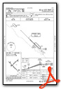
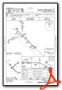
Instrument Approach Procedure (IAP) Charts

Nearby Airports with Instrument Procedures
| ID | Name | Heading / Distance | ||
|---|---|---|---|---|
 |
KOOA | Oskaloosa Municipal Airport | 343° | 7.4 |
|
4C8 | Albia Municipal Airport | 245° | 15.9 |
|
KFFL | Fairfield Municipal Airport | 098° | 21.4 |
|
4K6 | Bloomfield Municipal Airport | 177° | 22.5 |
|
KPEA | Pella Municipal Airport | 308° | 28.6 |
|
KOXV | Knoxville Municipal Airport | 291° | 32.3 |
|
KTVK | Centerville Municipal Airport | 219° | 32.7 |
|
KAWG | Washington Municipal Airport | 073° | 36.4 |
|
KGGI | Grinnell Regional Airport | 340° | 38.4 |
|
03D | Memphis Memorial Airport | 165° | 40.8 |
|
KCNC | Chariton Municipal Airport | 263° | 41.7 |
|
KTNU | Newton Municipal-Earl Johnson Field Airport | 322° | 42.8 |
Airport Images

By: Doreec88


