Login
Register


OZA
Ozona Municipal Airport
Official FAA Data Effective 2026-02-19 0901Z
Chart Supplement

VFR Chart of KOZA
Sectional Charts at SkyVector.com
IFR Chart of KOZA
Enroute Charts at SkyVector.com
Location Information for KOZA
Coordinates: N30°44.11' / W101°12.13'Located 01 miles N of Ozona, Texas on 143 acres of land. View all Airports in Texas.
Surveyed Elevation is 2376 feet MSL.
Operations Data
|
|
Airport Communications
| AWOS-3PT: | 118.425 Tel. 325-392-2051 |
|---|---|
| UNICOM: | 122.800 |
| CTAF: | 122.800 |
| AWOS-3 at SOA (30.0 E): | 118.075 325-387-3801 |
| AWOS-3PT at E41 (30.9 NW): | 118.4 325-884-2770 |
| AWOS-3 at 9TE2 (40.2 E): | 120.425 325-276-2771 |
- APCH/DEP CTL SVC PRVDD BY HOUSTON ARTCC ON FREQS 125.75/346.4 (ROCK SPRINGS RCAG).
Nearby Navigation Aids
|
| ||||||||||||||||||||||||||||||||||||||||||||||||


Runway 16/34
| Dimensions: | 6003 x 75 feet / 1830 x 23 meters | |
|---|---|---|
| Surface: | Asphalt in Good Condition | |
| Weight Limits: | S-30 | |
| Edge Lighting: | Medium Intensity | |
| Runway 16 | Runway 34 | |
| Coordinates: | N30°44.60' / W101°12.25' | N30°43.63' / W101°12.01' |
| Elevation: | 2376.8 | 2355.3 |
| Traffic Pattern: | Left | Left |
| Runway Heading: | 168° True | 348° True |
| Markings: | Non-Precision Instrument in good condition. | Non-Precision Instrument in good condition. |
| Glide Slope Indicator | P4L (3.00° Glide Path Angle) | P4L (3.00° Glide Path Angle) |
| Obstacles: | 40 ft Trees 830 ft from runway, 350 ft right of center | 50 ft Pole 1200 ft from runway, 45 ft right of center |
Services Available
| Fuel: | 100LL (blue), Jet-A |
|---|---|
| Transient Storage: | Tiedowns |
| Airframe Repair: | NOT AVAILABLE |
| Engine Repair: | NOT AVAILABLE |
| Bottled Oxygen: | NOT AVAILABLE |
| Bulk Oxygen: | NOT AVAILABLE |
Ownership Information
| Ownership: | Publicly owned | |
|---|---|---|
| Owner: | CROCKETT COUNTY | |
| PO BOX 1857 COUNTY COURTHOUSE | ||
| OZONA, TX 76943 | ||
| 325-392-2965 | ||
| Manager: | CHARLES MCCLEARY | |
| BOX 426 | ARPT PHYS ADDRESS 319 CR 308. | |
| OZONA, TX 76943 | ||
| 325-392-2030 | ||
Other Remarks
- FOR CD CTC HOUSTON ARTCC AT 281-230-5622.
- 0LL FOR AFT HRS FUEL CALL 325-226-2628.
- RWY 16/34 MIRL PRESET MED INTST; TO INCR INTST ACTVT - CTAF.
Weather Minimums

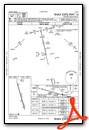
Instrument Approach Procedure (IAP) Charts
Nearby Airports with Instrument Procedures
| ID | Name | Heading / Distance | ||
|---|---|---|---|---|
 |
KSOA | Sonora Municipal Airport | 107° | 30.0 |
|
E41 | Reagan County Airport | 333° | 31.1 |
|
KSJT | San Angelo Regional/Mathis Field Airport | 044° | 52.1 |
|
KECU | Edwards County Airport | 131° | 71.3 |
|
KJCT | Kimble County Airport | 099° | 75.7 |
|
KDRT | Del Rio International Airport | 169° | 82.7 |
|
E30 | Bruce Field Airport | 047° | 84.5 |
|
KDLF | Laughlin AFB Airport | 164° | 85.3 |
|
KMAF | Midland International Air and Space Port Airport | 324° | 88.7 |
|
KFST | Fort Stockton-Pecos County Airport | 277° | 89.0 |
|
KBPG | Big Spring/Mc Mahon-Wrinkle Airport | 349° | 90.0 |
|
KMDD | Midland Airpark Airport | 329° | 90.6 |
Airport Images
Do you have a recent image of this airport? Upload it here!


