Login
Register


ECU
Edwards County Airport
Official FAA Data Effective 2026-01-22 0901Z
Chart Supplement

VFR Chart of KECU
Sectional Charts at SkyVector.com
IFR Chart of KECU
Enroute Charts at SkyVector.com
Location Information for KECU
Coordinates: N29°56.82' / W100°10.43'Located 04 miles SE of Rocksprings, Texas on 100 acres of land. View all Airports in Texas.
Surveyed Elevation is 2372 feet MSL.
Operations Data
|
|
Airport Communications
| AWOS-3: | 118.175 Tel. 830-683-2425 |
|---|---|
| DEL RIO APPROACH: | 119.6 259.1 |
| DEL RIO DEPARTURE: | 119.6 259.1 296.7 |
| CTAF: | 122.900 |
| AWOS-3 at 9TE2 (40.0 N): | 120.425 325-276-2771 |
| ASOS at JCT (40.0 NE): | 119.275 325-244-2722 |
| AWOS-3T at U66 (41.7 SE): | 121.125 210-384-5834 |
- APCH/DEP CTL SVC PRVDD BY HOUSTON ARTCC (ZHU) ON FREQS 125.75/346.4 (ROCK SPRINGS RCAG) WHEN DEL RIO APCH CTL (DLF) CLSD.
Nearby Navigation Aids
|
| ||||||||||||||||||||||||||||||||||||||||||||||||||||||||||||


Runway 14/32
| Dimensions: | 4050 x 50 feet / 1234 x 15 meters | |
|---|---|---|
| Surface: | Asphalt in Fair Condition | |
| Weight Limits: | S-13 | |
| Edge Lighting: | Medium Intensity | |
| Runway 14 | Runway 32 | |
| Coordinates: | N29°57.09' / W100°10.65' | N29°56.54' / W100°10.21' |
| Elevation: | 2367.1 | 2368.7 |
| Traffic Pattern: | Left | Left |
| Runway Heading: | 145° True | 325° True |
| Displaced Threshold: | 278 Feet NGT OPN DSPLCD THR LGTS ARE 288 FT FM RWY END. |
|
| Markings: | Non-Precision Instrument in poor condition. | Basic in poor condition. |
| Obstacles: | 25 ft Trees 201 ft from runway 20:1 TO DSPLCD THR OVR 25 FT TREES, 600 FT DSTC, 0 B. 8 FT MKD FENCE, 30 FT DSTC. |
23 ft Trees 780 ft from runway, 200 ft right of center |
Services Available
| Fuel: | NONE |
|---|---|
| Transient Storage: | Tiedowns |
| Airframe Repair: | NONE |
| Engine Repair: | NONE |
| Bottled Oxygen: | NOT AVAILABLE |
| Bulk Oxygen: | NOT AVAILABLE |
Ownership Information
| Ownership: | Publicly owned | |
|---|---|---|
| Owner: | COUNTY OF EDWARDS | |
| EDWARDS CTY COURTHOUSE, 100 WEST MAIN | ||
| ROCKSPRINGS, TX 78880 | ||
| 830-683-6122 | ||
| Manager: | JASON ARP | ROAD AND BRIDGE SUPT. |
| , BOX 348 | ||
| ROCKSPRINGS, TX 78880 | ||
| 830-683-7193 | ||
Other Remarks
- THIS AIRPORT HAS BEEN SURVEYED BY THE NATIONAL GEODETIC SURVEY.
- GATE ACES USE FLD ELEV.
- FOR CD CTC LAUGHLIN APCH AT 830-298-5192, WHEN APCH CLSD CTC HOUSTON ARTCC AT 281-230-5622.
- GRAVEL PIT ADJ TO RWY W SIDE, 12 FT DIRT PILES 156 FT FM RWY CL.
- MRKGS FADED.
- MRKGS FADED.
Weather Minimums

Instrument Approach Procedure (IAP) Charts
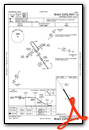

Nearby Airports with Instrument Procedures
| ID | Name | Heading / Distance | ||
|---|---|---|---|---|
 |
KJCT | Kimble County Airport | 032° | 40.0 |
|
KSOA | Sonora Municipal Airport | 327° | 45.5 |
|
KDLF | Laughlin AFB Airport | 222° | 47.3 |
|
KUVA | Garner Field Airport | 152° | 49.4 |
|
KDRT | Del Rio International Airport | 229° | 52.2 |
|
KERV | Kerrville Municipal/Louis Schreiner Field Airport | 087° | 56.8 |
|
KHDO | South Texas Regional At Hondo Airport | 123° | 62.9 |
|
5T9 | Maverick County Memorial International Airport | 195° | 67.6 |
|
T82 | Gillespie County Airport | 074° | 68.2 |
|
T92 | Mason County Airport | 047° | 69.6 |
|
KOZA | Ozona Municipal Airport | 311° | 71.3 |
|
KCVB | Castroville Municipal Airport | 117° | 78.0 |
Airport Images
Do you have a recent image of this airport? Upload it here!


