Login
Register


ILI
Iliamna Airport
Official FAA Data Effective 2026-01-22 0901Z
Chart Supplement

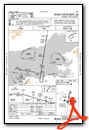
VFR Chart of PAIL
Sectional Charts at SkyVector.com
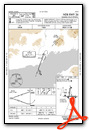
IFR Chart of PAIL
Enroute Charts at SkyVector.com
Location Information for PAIL
Coordinates: N59°45.33' / W154°55.07'Located 02 miles NW of Iliamna, Alaska. View all Airports in Alaska.
Surveyed Elevation is 192 feet MSL.
Operations Data
|
|
Airport Communications
| ASOS: | 134.95 Tel. 907-621-7977 |
|---|---|
| CTAF: | 123.600 |
| AWOS-3P at 05K (32.0 NE): | 118.025 336-837-4290 |
| AWOS-3P at IGG (39.6 SW): | 119.925 907-533-3350 |
- APCH/DEP SVC PRVDD BY ANCHORAGE ARTCC ON FREQ 118.8 (ILIAMNA RCAG).
- ILI AFIS ON 134.95. OPRS SAME HRS AS ILI FSS, 0545-2145; 15 MAY-15 OCT; OTR TIMES CTC KENAI FSS.
- COMMUNICATIONS PRVDD BY ILIAMNA FSS ON FREQ 123.6 (CTAF).
Nearby Navigation Aids
|
| ||||||||||||||||||||||||


Runway 08/26
| Dimensions: | 5086 x 100 feet / 1550 x 30 meters TUNDRA WHEEL GRVL SFC 275 FT PRIOR TO ASPH BOTH END; DALGT OPS ONLY. | |
|---|---|---|
| Surface: | Asphalt / Grooved in Good Condition | |
| Edge Lighting: | Medium Intensity | |
| Runway 08 | Runway 26 | |
| Coordinates: | N59°45.11' / W154°55.44' | N59°45.08' / W154°53.79' |
| Elevation: | 192.4 | 144.2 |
| Traffic Pattern: | Left | Left |
| Runway Heading: | 92° True | 272° True |
| Markings: | Non-Precision Instrument in fair condition. | Non-Precision Instrument in fair condition. |
| Glide Slope Indicator | P4L (3.00° Glide Path Angle) | P4L (3.00° Glide Path Angle) |
| REIL: | Yes | |
| Obstacles: | 10 ft Brush 200 ft from runway, 215 ft right of center | 12 ft Brush 200 ft from runway, 187 ft right of center |
Runway 18/36
| Dimensions: | 4800 x 100 feet / 1463 x 30 meters | |
|---|---|---|
| Surface: | Asphalt / Grooved in Good Condition | |
| Edge Lighting: | Medium Intensity | |
| Runway 18 | Runway 36 | |
| Coordinates: | N59°45.76' / W154°54.58' | N59°44.98' / W154°54.82' |
| Elevation: | 183.0 | 174.5 |
| Traffic Pattern: | Left | |
| Runway Heading: | 189° True | 9° True |
| Markings: | Non-Precision Instrument in fair condition. | Non-Precision Instrument in fair condition. |
| Glide Slope Indicator | P4L (3.00° Glide Path Angle) | P4L (3.00° Glide Path Angle) |
| REIL: | Yes | |
| Obstacles: | 12 ft Brush 200 ft from runway, 195 ft left of center | 4 ft Brush 200 ft from runway, 165 ft right of center |
Runway E/W
| Dimensions: | 2998 x 400 feet / 914 x 122 meters | |
|---|---|---|
| Surface: | Water in Excellent Condition | |
| Runway E | Runway W | |
| Coordinates: | N59°45.62' / W154°56.22' | N59°45.55' / W154°55.25' |
| Elevation: | 170.0 | 170.0 |
| Traffic Pattern: | Left | |
Runway N/S
| Dimensions: | 2892 x 400 feet / 881 x 122 meters | |
|---|---|---|
| Surface: | Water in Excellent Condition | |
| Runway N | Runway S | |
| Coordinates: | N59°45.22' / W154°55.92' | N59°45.67' / W154°55.62' |
| Elevation: | 170.0 | 170.0 |
| Traffic Pattern: | Right | |
Services Available
| Fuel: | 100LL (blue), Jet-A |
|---|---|
| Transient Storage: | Tiedowns |
| Airframe Repair: | NOT AVAILABLE |
| Engine Repair: | NOT AVAILABLE |
| Bottled Oxygen: | NOT AVAILABLE |
| Bulk Oxygen: | NOT AVAILABLE |
Ownership Information
| Ownership: | Publicly owned | |
|---|---|---|
| Owner: | ALASKA DOT&PF SOUTHCOAST REGION | |
| PO BOX 112506 | ||
| JUNEAU, AK 99811-2506 | ||
| (907) 465-1779 | ||
| Manager: | TREFIM ANDREW | |
| BOX 187 | ||
| ILIAMNA, AK 99606 | ||
| 907-571-1261 | ||
Other Remarks
- SNOW & ICE REMOVAL & HAZ RPRTNG DURG DUTY HR; EXC PPR IN WRITING - AMGR.
- SAFETY AREAS SOFT.
- MULT AIRSTRIPS & FLOAT PLANE BASINS INVOF ARPT; LOW-LEVEL HEL SLING LOAD OPS WI 25 NM W-NW; MNT CTAF & SELF ANNOUNCE UPON ENTRY.
- BE ALERT: NO LINE OF SIGHT BTN ILIAMNA, PIKE LAKE & EAST WIND LAKE/STRIP; TFC PAT & VFR ARR & DEP PROC SEE SECTION C NOTICE.
- TSNT PRKG MKD WITH GREEN CONES.
- WX CAMERAS AVBL ON INTERNET AT HTTPS://WEATHERCAMS.FAA.GOV/.
- ARPT SAND LRGR THAN FAA RCMDD/SEE AC150/5200-30.
- WX OBS 16 OCT-14 MAY 0545-2145 - ILIAMNA WX 133.75 OR 907-571-1240.
- COLD TEMPERATURE AIRPORT. ALTITUDE CORRECTION REQUIRED AT OR BELOW -26C.
- TAXI ON ACTIVE RWYS; LOCKED BRAKE TURNS ON RWYS NA.
- PSNL & EQPT MAY BE ON RWY.
- WHEN FSS CLSD ACTVT REIL RWY 26 & 36; PAPI RWY 18, 36, 08, & 26; MIRL RWY 08/26; 18/36 - CTAF.
Weather Minimums


Instrument Approach Procedure (IAP) Charts


Nearby Airports with Instrument Procedures
| ID | Name | Heading / Distance | ||
|---|---|---|---|---|
 |
PANO | Nondalton Airport | 009° | 13.7 |
|
PFKK | Kokhanok Airport | 169° | 19.7 |
|
PAKX | Wilder Runway Airport | 033° | 32.1 |
|
PAIG | Igiugig Airport | 229° | 39.7 |
|
PAJZ | Koliganek Airport | 269° | 71.1 |
|
PANW | New Stuyahok Airport | 257° | 77.1 |
|
PAKN | King Salmon Airport | 220° | 84.0 |
|
PFWS | South Naknek Nr 2 Airport | 226° | 90.2 |
|
PAII | Egegik Airport | 220° | 121.4 |
|
PASL | Sleetmute Airport | 331° | 134.4 |
Airport Images
Do you have a recent image of this airport? Upload it here!


