Login
Register


UUO
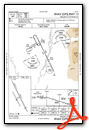
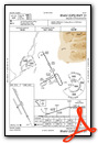
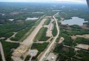
Willow Airport
Official FAA Data Effective 2026-01-22 0901Z
Chart Supplement

VFR Chart of PAUO
Sectional Charts at SkyVector.com
IFR Chart of PAUO
Enroute Charts at SkyVector.com
Location Information for PAUO
Coordinates: N61°45.25' / W150°3.10'Located 01 miles NW of Willow, Alaska on 610 acres of land. View all Airports in Alaska.
Surveyed Elevation is 215 feet MSL.
Operations Data
|
|
Airport Communications
| CTAF: | 122.800 |
|---|---|
| AWOS-3P at IYS (18.2 SE): | 135.25 907-373-3801 |
| AWOS-3P at BCV (25.5 SE): | 135.55 907-621-7605 |
| ASOS at PAQ (29.0 E): | 134.75 907-746-6675 |
- APCH/DEP SVC PRVDD BY ANCHORAGE ARTCC (BIG LAKE RCAG) ON FREQS 133.7/279.6.
Nearby Navigation Aids
|
| ||||||||||||||||||||||||||||||||||||


Runway 13/31
| Dimensions: | 4400 x 75 feet / 1341 x 23 meters | |
|---|---|---|
| Surface: | Gravel in Good Condition | |
| Edge Lighting: | Medium Intensity | |
| Runway 13 | Runway 31 | |
| Coordinates: | N61°45.59' / W150°3.44' | N61°44.94' / W150°2.77' |
| Elevation: | 200.3 | 215.3 |
| Traffic Pattern: | Left | Right |
| Runway Heading: | 154° True | 334° True |
| Displaced Threshold: | 400 Feet | |
| Markings: | Non-Standard | Non-Standard |
| Obstacles: | 15 ft Road 158 ft from runway | 43 ft Trees 300 ft from runway, 200 ft right of center APCH SLP 20:1 TO DTHR. |
Services Available
| Fuel: | 100LL (blue) |
|---|---|
| Transient Storage: | Hangars,Tiedowns |
| Airframe Repair: | MAJOR |
| Engine Repair: | MAJOR |
| Bottled Oxygen: | NOT AVAILABLE |
| Bulk Oxygen: | NOT AVAILABLE |
| Other Services: | CHARTER SERVICE,PILOT INSTRUCTION |
Ownership Information
| Ownership: | Publicly owned | |
|---|---|---|
| Owner: | ALASKA DOT&PF CENTRAL REGION | |
| PO BOX 196900 | ||
| ANCHORAGE, AK 99519-6900 | ||
| 907-269-0770 | ||
| Manager: | RAY ADAMS | |
| ST OF AK -- DOTPF WILLOW STATION, PO BOX 889 | ||
| WILLOW, AK 99688 | ||
| 907-495-6286 | ||
Other Remarks
- RWY COND UNMNT; RCMD VISUAL INSP BFR USE.
- FLOAT PLANES ON WILLOW LAKE ACRS ROAD.
- WX RPRT HRLY WHEN AVBL.
- WX CAMERA AVBL ON INTERNET AT HTTPS://WEATHERCAMS.FAA.GOV
- THR MKD WITH FLEXIBLE REFLECTIVE MKRS & CONES.
- DTHR MKD WITH FLEXIBLE REFLECTIVE MKRS & CONES. TWY MARKINGS THRU DTHR.
- 0LL CREDIT CARD SELF SVC H24.
- ACTVT MIRL RWY 13/31 - CTAF.
- ACVT ROTG BCN - CTAF.
Weather Minimums

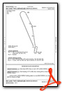
Instrument Approach Procedure (IAP) Charts
Departure Procedure Obstacles (DPO) Charts
Nearby Airports with Instrument Procedures
| ID | Name | Heading / Distance | ||
|---|---|---|---|---|
 |
PAGQ | Big Lake Airport | 152° | 14.9 |
|
PAWS | Wasilla Airport | 126° | 18.3 |
|
PAAQ | Warren "Bud" Woods Palmer Municipal Airport | 108° | 29.2 |
|
PAED | Elmendorf AFB Airport | 166° | 31.1 |
|
PAMR | Merrill Field Airport | 169° | 33.1 |
|
PATK | Talkeetna Airport | 358° | 34.2 |
|
PANC | Ted Stevens Anchorage International Airport | 177° | 34.9 |
|
PAEN | Kenai Municipal Airport | 206° | 79.1 |
|
PASX | Soldotna Airport | 200° | 82.2 |
|
PAWD | Seward Airport | 168° | 99.5 |
Airport Images
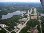
By: tgeorge
By: tgeorge


