Login
Register


TLJ
Tatalina LRRS Airport
Official FAA Data Effective 2025-11-27 0901Z
Chart Supplement

VFR Chart of PATL
Sectional Charts at SkyVector.com
IFR Chart of PATL
Enroute Charts at SkyVector.com
Location Information for PATL
Coordinates: N62°53.69' / W155°58.68'Located 07 miles S of Takotna, Alaska. View all Airports in Alaska.
Estimated Elevation is 933 feet MSL.
Operations Data
|
|
Airport Communications
| AWOS-3: | Tel. 907-552-1106 |
|---|---|
| CTAF: | 126.200 |
| ASOS at MCG (10.7 E): | 135.65 907-524-3850 |
| AWOS-3P at FSP (44.6 E): | 118.325 907-560-7606 |
Nearby Navigation Aids
|
| ||||||||||||||||||

Runway 17/35
LATERAL SLOPE; W EDGE HYR THAN E EDGE. EXP TURB BOTH ENDS. | ||
| Dimensions: | 3820 x 150 feet / 1164 x 46 meters | |
|---|---|---|
| Surface: | Gravel | |
| Runway 17 | Runway 35 | |
| Coordinates: | N62°54.01' / W155°58.65' | N62°53.38' / W155°58.71' |
| Elevation: | 932.6 | 891.4 |
| Traffic Pattern: | Left | Left |
| Runway Heading: | 182° True | 2° True |
| Markings: | Non-Standard | Non-Standard |
| Glide Slope Indicator | P2R (5.00° Glide Path Angle) PAPI RWY 17 BAFFLED & UNUSBL BYD 5 DEGS RIGHT OF CNTRLN. | P2L (3.00° Glide Path Angle) |
| REIL: | Yes | Yes |
| Obstacles: | ft Hill ft from runway MT 13000 FT FM THR. |
|
Services Available
| Fuel: | NONE |
|---|---|
| Transient Storage: | NONE |
| Airframe Repair: | NOT AVAILABLE |
| Engine Repair: | NOT AVAILABLE |
| Bottled Oxygen: | NOT AVAILABLE |
| Bulk Oxygen: | NOT AVAILABLE |
| Other Services: | CARGO HANDLING SERVICES |
Ownership Information
| Ownership: | Owned by the Air Force | |
|---|---|---|
| Owner: | U.S. AIR FORCE 611TH AIR SPT GP. | |
| 10471 20TH STREET, SUITE 361 | ||
| ELMENDORF AFB, AK 99506 | ||
| 907-552-3442 | ||
| Manager: | NICK HILTON | |
| 10471 20TH STREET, SUITE 222 | ||
| ELMENDORF, AK 99506 | ||
| 907-552-7610 | ||
Other Remarks
- PAX MUST COORD BFR NON EMERG TRAVEL TO SITE - D317-552-4935/1089/C907-552-4935/1089.
- WX CAMERA AVBL ON INTERNET AT HTTPS://WEATHERCAMS.FAA.GOV
- PRKG FAC RSTRD TO TWO C123.
- RADIO - 364.2/126.2.
- AFT INITIAL CTC EXP 30 MIN DLA FOR COND RPRT.
- USAF FAC; CIV ACFT LNDG PMT RQRD BFR ARR - D317-552-5282/C907-552-5282 OR MAIL ATTN: 11 AF AMGR 10471 20TH STREET SUITE 218 ELMENDORF AFB AK 99506.
- PPR ALL OPS; MNM 1 HR PRIOR TO DEP FOR SITE & NO EARLIER THAN DAY TRAVEL - D317-552-1106/1040/C907-552-1106/1040.
- 2 X 3 FT ORANGE MKRS.
- 2 X 3 FT ORANGE MKRS.
- OPR CONSLY.
Weather Minimums
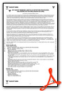
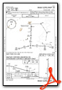
Instrument Approach Procedure (IAP) Charts
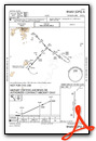
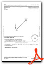
Departure Procedure Obstacles (DPO) Charts
Nearby Airports with Instrument Procedures
| ID | Name | Heading / Distance | ||
|---|---|---|---|---|
 |
PAMC | Mc Grath Airport | 070° | 10.8 |
|
PAFS | Nikolai Airport | 079° | 45.0 |
|
PASL | Sleetmute Airport | 205° | 79.2 |
|
PACJ | Crooked Creek Airport | 225° | 86.2 |
|
PARY | Ruby Airport | 006° | 111.1 |
|
PAKV | Kaltag Airport | 320° | 113.2 |
|
PAGA | Edward G Pitka Sr Airport | 347° | 113.7 |
|
PANU | Nulato Airport | 334° | 123.7 |
|
PFKU | Koyukuk Airport | 339° | 128.0 |
Airport Images
Do you have a recent image of this airport? Upload it here!


