Login
Register


PIA
General Downing - Peoria International Airport
Official FAA Data Effective 2025-11-27 0901Z
Chart Supplement

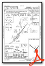
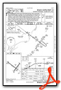
KPIA Airport Diagram

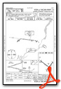
VFR Chart of KPIA
Sectional Charts at SkyVector.com
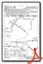
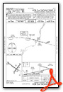
IFR Chart of KPIA
Enroute Charts at SkyVector.com
Location Information for KPIA
Coordinates: N40°39.85' / W89°41.60'Located 04 miles W of Peoria, Illinois on 3800 acres of land. View all Airports in Illinois.
Surveyed Elevation is 660 feet MSL.
Operations Data
|
|
Airport Communications
| ATIS: | 126.1 282.2 |
|---|---|
| ASOS: | Tel. 309-322-3740 |
| PEORIA TOWER: | 124.0 353.85 |
| PEORIA GROUND: | 121.85 348.6 |
| SAINT LOUIS APPROACH: | 125.8 269.2 |
| SAINT LOUIS DEPARTURE: | 125.8 269.2 |
| CLEARANCE DELIVERY: | 124.675 317.55 |
| ARNG OPS: | 141.15 280.9 38.925 |
| EMERG: | 121.5 243.0 |
| CLASS C: | 125.8 269.2 |
| ANG OPS: | 141.35 282.825 |
| UNICOM: | 122.950 |
| AWOS-3 at C75 (25.5 NE): | 119.425 309-246-3089 |
| AWOS-3 at AAA (34.5 SE): | 118.775 217-732-9605 |
| ATIS at BMI (37.2 E): | 119.575 |
Nearby Navigation Aids
|
| ||||||||||||||||||||||||||||||||||||||||||||||||||||||||||||


Runway 13/31
| Dimensions: | 10104 x 150 feet / 3080 x 46 meters | |
|---|---|---|
| Surface: | Concrete / Grooved in Good Condition | |
| Weight Limits: | S-100, D-175, ST-310
PCR VALUE: 760/F/C/X/T
| |
| Edge Lighting: | High Intensity | |
| Runway 13 | Runway 31 | |
| Coordinates: | N40°40.42' / W89°42.83' | N40°39.43' / W89°41.08' |
| Elevation: | 635.7 | 642.2 |
| Traffic Pattern: | Left | Left |
| Runway Heading: | 127° True | 307° True |
| Displaced Threshold: | 500 Feet | |
| Declared Distances: | TORA:10104 TODA:10104 ASDA:9604 LDA:9604 | TORA:10104 TODA:10104 ASDA:10104 LDA:10104 |
| Markings: | Precision Instrument in good condition. | Precision Instrument in good condition. |
| Glide Slope Indicator | P4R (3.00° Glide Path Angle) | |
| RVR Equipment | Touchdown Rollout | Touchdown Rollout |
| Approach Lights: | MALSR 1,400 Foot Medium-intensity Approach Lighting System with runway alignment indicator lights. | MALSR 1,400 Foot Medium-intensity Approach Lighting System with runway alignment indicator lights. |
| Obstacles: | 137 ft Tree 5034 ft from runway, 254 ft left of center APCH SLOPE 36:1 TO DSPLCD THLD. |
79 ft Tree 3695 ft from runway, 458 ft right of center |
Runway 04/22
| Dimensions: | 8004 x 150 feet / 2440 x 46 meters | |
|---|---|---|
| Surface: | Asphalt / Grooved in Fair Condition | |
| Weight Limits: | S-100, D-175, ST-300
PCR VALUE: 800/F/C/X/T
| |
| Edge Lighting: | High Intensity | |
| Runway 04 | Runway 22 | |
| Coordinates: | N40°39.24' / W89°41.68' | N40°40.27' / W89°40.60' |
| Elevation: | 642.5 | 656.7 |
| Traffic Pattern: | Left | Left |
| Runway Heading: | 39° True | 219° True |
| Declared Distances: | TORA:8004 TODA:8004 ASDA:7826 LDA:7826 | TORA:8004 TODA:8004 ASDA:8004 LDA:8004 |
| Markings: | Precision Instrument in fair condition. | Precision Instrument in fair condition. |
| Glide Slope Indicator | P4R (3.00° Glide Path Angle) | P4L (3.00° Glide Path Angle) RWY 22 PAPI UNUSBL BYD 9 DEGS RIGHT OF CNTRLN. |
| RVR Equipment | Touchdown Rollout | Touchdown Rollout |
| Approach Lights: | MALSR 1,400 Foot Medium-intensity Approach Lighting System with runway alignment indicator lights. | |
| Obstacles: | 47 ft Tree 1013 ft from runway, 291 ft right of center | 93 ft Tree 2500 ft from runway |
Services Available
| Fuel: | 100LL (blue), Jet-A, A++ |
|---|---|
| Transient Storage: | Hangars,Tiedowns |
| Airframe Repair: | MAJOR |
| Engine Repair: | MAJOR |
| Bottled Oxygen: | NONE |
| Bulk Oxygen: | HIGH/LOW |
| Other Services: | CHARTER SERVICE,PILOT INSTRUCTION,AIRCRAFT RENTAL,AIRCRAFT SALES |
Ownership Information
| Ownership: | Publicly owned | |
|---|---|---|
| Owner: | METROPOLITAN ARPT AUTH OF PEORIA | |
| 6100 WEST E.M. DIRKSEN PKWY | ||
| PEORIA, IL 61607 | ||
| 309-697-8272 | ||
| Manager: | GENE OLSON | |
| 6100 WEST E.M. DIRKSEN PKWY | ||
| PEORIA, IL 61607 | ||
| 309-697-8272 | AIRPORT OPERATIONS 309-697-8272 X 110 | |
Other Remarks
- LGTD PLINE RWY 04 APCH.
- BIRDS ON AND INVOF ARPT.
- PORTION OF TWY A-5 NOT VISIBLE FROM TWR DUE TO A BLDG.
- ANG: MILITARY AIRCRAFT CALL 'TORCH OPS' 20 MIN PRIOR TO LDG.
Weather Minimums
Instrument Approach Procedure (IAP) Charts


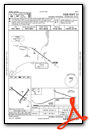
Nearby Airports with Instrument Procedures
| ID | Name | Heading / Distance | ||
|---|---|---|---|---|
 |
3MY | Mount Hawley Auxiliary Airport | 024° | 8.7 |
|
C15 | Pekin Municipal Airport | 175° | 10.6 |
|
KCTK | Ingersoll Airport | 252° | 18.3 |
|
C75 | Marshall County Airport | 033° | 25.5 |
|
KAAA | Logan County Airport | 151° | 34.5 |
|
KEZI | Kewanee Municipal Airport | 339° | 34.7 |
|
KBMI | Central Il Regional/Bloomington-Normal Airport | 107° | 37.3 |
|
KGBG | Harrel W Timmons Galesburg Regional Airport | 296° | 37.4 |
|
KMQB | Macomb Municipal Airport | 259° | 44.7 |
|
C66 | Monmouth Municipal Airport | 290° | 45.6 |
|
KVYS | Illinois Valley Regional-Walter A Duncan Field Airport | 030° | 47.9 |
|
KSPI | Abraham Lincoln Capital Airport | 179° | 49.1 |
Airport Images
By: AirMarshall


