Login
Register


CTK
Ingersoll Airport
Official FAA Data Effective 2026-01-22 0901Z
Chart Supplement

VFR Chart of KCTK
Sectional Charts at SkyVector.com
IFR Chart of KCTK
Enroute Charts at SkyVector.com
Location Information for KCTK
Coordinates: N40°34.14' / W90°4.49'Located 02 miles NW of Canton, Illinois on 232 acres of land. View all Airports in Illinois.
Surveyed Elevation is 683 feet MSL.
Operations Data
|
|
Airport Communications
| AWOS-A: | 122.8 Tel. 309-647-0699 |
|---|---|
| SAINT LOUIS APPROACH: | 125.8 269.2 |
| SAINT LOUIS DEPARTURE: | 125.8 269.2 |
| CTAF: | 122.800 |
| UNICOM: | 122.800 |
| ATIS at PIA (18.3 E): | 126.1 |
| ASOS at PIA (18.3 E): | 309-322-3740 |
| AWOS-3 at MQB (26.5 W): | 119.025 309-837-4022 |
Nearby Navigation Aids
|
| ||||||||||||||||||||||||||||||||||||||||||||||||||||||||||||


Runway 18/36
| Dimensions: | 3899 x 75 feet / 1188 x 23 meters | |
|---|---|---|
| Surface: | Asphalt in Good Condition | |
| Weight Limits: | S-10 | |
| Edge Lighting: | Medium Intensity | |
| Runway 18 | Runway 36 | |
| Coordinates: | N40°34.38' / W90°4.43' | N40°33.74' / W90°4.45' |
| Elevation: | 681.9 | 670.3 |
| Traffic Pattern: | Left | Left |
| Runway Heading: | 181° True | 1° True |
| Markings: | Non-Precision Instrument in fair condition. | Non-Precision Instrument in fair condition. |
| REIL: | Yes | |
Runway 09/27
| Dimensions: | 3294 x 60 feet / 1004 x 18 meters | |
|---|---|---|
| Surface: | Asphalt in Good Condition | |
| Weight Limits: | S-11 | |
| Edge Lighting: | Medium Intensity | |
| Runway 09 | Runway 27 | |
| Coordinates: | N40°34.24' / W90°4.90' | N40°34.24' / W90°4.19' |
| Elevation: | 683.8 | 681.8 |
| Traffic Pattern: | Left | Left |
| Runway Heading: | 89° True | 269° True |
| Markings: | Basic in fair condition. | Basic in fair condition. |
| Obstacles: | 53 ft Trees 953 ft from runway, 92 ft left of center | |
Services Available
| Fuel: | 100LL (blue) |
|---|---|
| Transient Storage: | Tiedowns |
| Airframe Repair: | MAJOR |
| Engine Repair: | MAJOR |
| Bottled Oxygen: | NONE |
| Bulk Oxygen: | NONE |
| Other Services: | PILOT INSTRUCTION,AIRCRAFT RENTAL |
Ownership Information
| Ownership: | Publicly owned | |
|---|---|---|
| Owner: | CANTON PARK DISTRICT | |
| 250 S AVE D | ||
| CANTON, IL 61520 | ||
| 309-647-1345 | ||
| Manager: | BRENT WHEELER | |
| 250 S AVE D | EMAIL ADDRESS: CPD_JOHNSON@SBCGLOBAL.NET (ALL LOWER CASE) | |
| CANTON, IL 61520 | ||
| 309-647-1345 | ||
Other Remarks
- AWOS (DIGIWX) DECOMISSIONED
- FOR CD CTC ST LOUIS APCH AT 314-890-1017.
- AIRPORT BEACON NOT INSTALLED
- 0LL SELF-SERV FUELING
- ACTVT MIRL RYS 09/27 & 18/36 & REIL RY 36 & TWY LGTS - 7 CLICKS ON CTAF.
Weather Minimums

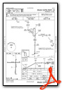
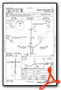
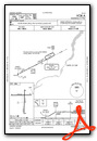
Instrument Approach Procedure (IAP) Charts
Nearby Airports with Instrument Procedures
| ID | Name | Heading / Distance | ||
|---|---|---|---|---|
 |
KPIA | General Downing - Peoria International Airport | 071° | 18.3 |
|
C15 | Pekin Municipal Airport | 104° | 18.9 |
|
3MY | Mount Hawley Auxiliary Airport | 057° | 25.1 |
|
KMQB | Macomb Municipal Airport | 263° | 26.6 |
|
KGBG | Harrel W Timmons Galesburg Regional Airport | 323° | 27.4 |
|
C66 | Monmouth Municipal Airport | 310° | 33.3 |
|
KEZI | Kewanee Municipal Airport | 007° | 38.5 |
|
C75 | Marshall County Airport | 049° | 41.4 |
|
KAAA | Logan County Airport | 125° | 41.9 |
|
KSPI | Abraham Lincoln Capital Airport | 157° | 47.1 |
|
KIJX | Jacksonville Municipal Airport | 189° | 48.2 |
|
I63 | Mount Sterling Municipal Airport | 223° | 48.4 |
Airport Images
Do you have a recent image of this airport? Upload it here!


