Login
Register


PSF
Pittsfield Municipal Airport
Official FAA Data Effective 2026-02-19 0901Z
Chart Supplement

VFR Chart of KPSF
Sectional Charts at SkyVector.com
IFR Chart of KPSF
Enroute Charts at SkyVector.com
Location Information for KPSF
Coordinates: N42°25.66' / W73°17.45'Located 02 miles W of Pittsfield, Massachusetts on 550 acres of land. View all Airports in Massachusetts.
Surveyed Elevation is 1188 feet MSL.
Operations Data
|
|
Airport Communications
| ASOS: | 135.375 Tel. 413-499-3273 |
|---|---|
| ALBANY APPROACH: | 132.825 307.2 |
| ALBANY DEPARTURE: | 132.825 307.2 |
| CLEARANCE DELIVERY: | 128.6 |
| UNICOM: | 122.700 |
| CTAF: | 122.700 |
| ASOS at AQW (17.0 N): | 134.775 413-664-6658 |
| AWOS-3 at 1B1 (20.3 SW): | 133.525 518-828-2577 |
| ASOS at DDH (28.0 N): | 135.925 802-442-6059 |
Nearby Navigation Aids
|
| ||||||||||||||||||||||||||||||||||||||||||||||||||||||||||||


Runway 08/26
| Dimensions: | 5792 x 101 feet / 1765 x 31 meters | |
|---|---|---|
| Surface: | Asphalt / Grooved in Good Condition | |
| Weight Limits: | S-80, D-102, ST-159
PCR VALUE: 326/F/D/X/T
| |
| Edge Lighting: | Medium Intensity | |
| Runway 08 | Runway 26 | |
| Coordinates: | N42°25.47' / W73°18.01' | N42°25.89' / W73°16.86' |
| Elevation: | 1188.5 | 1132.1 |
| Traffic Pattern: | Left | Right |
| Runway Heading: | 64° True | 244° True |
| Markings: | Precision Instrument in good condition. | Precision Instrument in good condition. |
| Glide Slope Indicator | P4L (3.00° Glide Path Angle) | |
| REIL: | Yes | |
| Obstacles: | 35 ft Trees 750 ft from runway, 350 ft left of center | |
Runway 14/32
| Dimensions: | 3147 x 76 feet / 959 x 23 meters | |
|---|---|---|
| Surface: | Asphalt in Good Condition | |
| Weight Limits: | S-12
PCR VALUE: 42/F/D/X/T
| |
| Edge Lighting: | Medium Intensity | |
| Runway 14 | Runway 32 | |
| Coordinates: | N42°25.76' / W73°17.76' | N42°25.47' / W73°17.18' |
| Elevation: | 1171.6 | 1144.7 |
| Traffic Pattern: | Left | Right |
| Runway Heading: | 123° True | 303° True |
| Markings: | Basic in good condition. | Basic in good condition. |
| Obstacles: | 50 ft Trees 1000 ft from runway, 125 ft left of center | 20 ft Trees 600 ft from runway, 120 ft left of center |
Services Available
| Fuel: | 100LL (blue), Jet-A, Jet A+ |
|---|---|
| Transient Storage: | Hangars,Tiedowns |
| Airframe Repair: | MAJOR |
| Engine Repair: | MAJOR |
| Bottled Oxygen: | LOW |
| Bulk Oxygen: | NONE |
| Other Services: | AIR AMBULANCE SERVICES,AVIONICS,CHARTER SERVICE,PILOT INSTRUCTION,AIRCRAFT RENTAL,AIRCRAFT SALES |
Ownership Information
| Ownership: | Publicly owned | |
|---|---|---|
| Owner: | CITY OF PITTSFIELD | |
| 70 ALLEN ST | ||
| PITTSFIELD, MA 01201 | ||
| 413-448-9790 | ||
| Manager: | ANITA AKOR | |
| PITTSFIELD MUNICIPAL AIRPORT, 832 TAMARACK RD | ||
| PITTSFIELD, MA 01201 | ||
| 413-448-9790 | ||
Other Remarks
- OBSTN LGTD POLES 0.9 NM SE AT 1960 FT; 1.1 NM SE AT 1470 FT; 1.7 NM SW AT 2171 FT (OTS INDEFLY); 1.3 NM NE AT 1330 FT; 2.3 NM NW AT 1890 FT (OTS INDEFLY).
- FOR CD CTC ALBANY APCH AT 518-862-2299.
- FBO ATNDD MON-FRI 0800-1800, SAT-SUN 0800-1700. FOR FUEL AFT HRS CALL 413-443-6700.
- RWY 14-32 CK NOTAMS FOR CHGS TO LEN & WID.
- COLD TEMPERATURE AIRPORT. ALTITUDE CORRECTION REQUIRED AT OR BELOW -21C.
- BIRDS & WILDLIFE ON & INVOF ARPT.
- ALL ACFT USE TWY A, C & D FOR RWY 08-26. TWY A USE LTD TO ACFT WITH WINGSPAN LESS THAN 79 FT. AFT BACK TAX RWY 26 USE TWY D TO TURN ARND.
- CK NOTAMS FOR ARPT COND. AIRFIELD SFC COND NOT MNT & SNOW REMOVAL NOT GUARANTEED BTN 1500-0700.
- NOISE ABATEMENT PROCS IN EFCT 2300-0700.
- ACTVT REIL RWY 26; PAPI RWY 26; MIRL RWY 08/26 & 14/32 - CTAF.
Weather Minimums

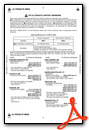
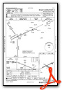
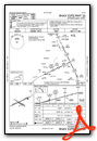
Instrument Approach Procedure (IAP) Charts

Nearby Airports with Instrument Procedures
| ID | Name | Heading / Distance | ||
|---|---|---|---|---|
 |
KGBR | Great Barrington Airport | 198° | 15.4 |
|
KAQW | Harriman-and-West Airport | 018° | 17.0 |
|
1B1 | Columbia County Airport | 246° | 20.4 |
|
4B0 | South Albany Airport | 288° | 25.4 |
|
KDDH | William H Morse State Airport | 004° | 27.9 |
|
KALB | Albany International Airport | 310° | 29.8 |
|
KBAF | Westfield-Barnes Regional Airport | 122° | 30.3 |
|
7B2 | Northampton Airport | 100° | 30.8 |
|
0B5 | Turners Falls Airport | 073° | 35.5 |
|
KCEF | Westover Arb/Metro Airport | 112° | 36.5 |
|
KSCH | Schenectady County Airport | 312° | 38.1 |
|
KBDL | Bradley International Airport | 137° | 39.9 |
Airport Images

By: kcmacm


