Login
Register


RBE
Rock County Airport
Official FAA Data Effective 2026-02-19 0901Z
Chart Supplement

VFR Chart of KRBE
Sectional Charts at SkyVector.com
IFR Chart of KRBE
Enroute Charts at SkyVector.com
Location Information for KRBE
Coordinates: N42°34.27' / W99°34.17'Located 02 miles SW of Bassett, Nebraska on 228 acres of land. View all Airports in Nebraska.
Surveyed Elevation is 2349 feet MSL.
Operations Data
|
|
Airport Communications
| CTAF: | 122.900 |
|---|---|
| AWOS-3 at ANW (19.0 W): | 118.325 402-387-2329 |
| AWOS-3 at ONL (39.5 E): | 121.125 402-336-4834 |
| ASOS at VTN (46.6 NW): | 118.075 402-988-1984 |
- APCH/DEP CTL SVC PRVDD BY DENVER ARTCC (ZDV) ON FREQS 127.95/338.2 (AINSWORTH RCAG).
Nearby Navigation Aids
|
| ||||||||||||||||||||||||||||||||||||||||||||||||


Runway 13/31
| Dimensions: | 4698 x 75 feet / 1432 x 23 meters | |
|---|---|---|
| Surface: | Concrete in Good Condition | |
| Weight Limits: | S-4 | |
| Edge Lighting: | Medium Intensity | |
| Runway 13 | Runway 31 | |
| Coordinates: | N42°34.48' / W99°34.43' | N42°33.88' / W99°33.77' |
| Elevation: | 2344.4 | 2349.4 |
| Traffic Pattern: | Left | Left |
| Runway Heading: | 141° True | 321° True |
| Markings: | Non-Precision Instrument in good condition. | Non-Precision Instrument in good condition. |
| Glide Slope Indicator | P2L (3.00° Glide Path Angle) | P2L (3.00° Glide Path Angle) |
| Obstacles: | FENCE PARLS RWY CTRLN; 250 FT LEFT TO 400 FT PAST RWY END. RWY 31 CLNC SLOPE ON CTRLN 50:1. |
4 ft Fence 200 ft from runway, 250 ft left of center |
Runway 02/20
| Dimensions: | 2202 x 120 feet / 671 x 37 meters | |
|---|---|---|
| Surface: | Turf in Fair Condition | |
| Runway 02 | Runway 20 | |
| Coordinates: | N42°34.31' / W99°34.46' | N42°34.60' / W99°34.18' |
| Elevation: | 2343.9 | 2341.9 |
| Traffic Pattern: | Left | Left |
| Runway Heading: | 35° True | 215° True |
Services Available
| Fuel: | 100LL (blue) |
|---|---|
| Transient Storage: | Hangars,Tiedowns |
| Airframe Repair: | NONE |
| Engine Repair: | NONE |
| Bottled Oxygen: | NONE |
| Bulk Oxygen: | NONE |
| Other Services: | CROP DUSTING SERVICES |
Ownership Information
| Ownership: | Publicly owned | |
|---|---|---|
| Owner: | ROCK COUNTY AIRPORT AUTHORITY | |
| PO BOX 7, PO BOX 385 | ||
| BASSETT, NE 68714-0007 | ||
| 402-684-3436 | ||
| Manager: | BERNIE HART | |
| 504 S. STATE STREET | ||
| BASSETT, NE 68714-5046 | ||
| 402-684-2254 | ||
Other Remarks
- DEER ON & INVOF ARPT.
- (E81) <TURNOFF LGTS ONLY.
- FOR CD CTC DENVER ARTCC AT 303-651-4257.
- 0LL 24 HR CREDIT CARD
- ACTVT MIRL RY 13/31 & PAPI RYS 13 & 31 - CTAF.
Weather Minimums

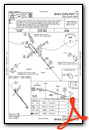
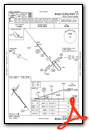
Instrument Approach Procedure (IAP) Charts
Nearby Airports with Instrument Procedures
| ID | Name | Heading / Distance | ||
|---|---|---|---|---|
 |
KANW | Ainsworth Regional Airport | 271° | 18.8 |
|
8V2 | Stuart-Atkinson Municipal Airport | 091° | 23.5 |
|
KONL | The O'Neill Municipal-John L Baker Field Airport | 098° | 39.6 |
|
9D1 | Gregory Municipal/Flynn Field Airport | 010° | 39.7 |
|
KVTN | Miller Field Airport | 291° | 46.6 |
|
KICR | Winner Regional Airport | 346° | 50.5 |
|
KBUB | Cram Field Airport | 158° | 51.1 |
|
KTIF | Thomas County Airport | 231° | 57.6 |
|
KODX | Evelyn Sharp Field Airport | 153° | 63.2 |
|
KAGZ | Wagner Municipal Airport | 061° | 63.5 |
|
KBBW | Broken Bow Municipal/Keith Glaze Field Airport | 182° | 68.1 |
|
KSUO | Rosebud Sioux Tribal Airport | 306° | 70.2 |
Airport Images
Do you have a recent image of this airport? Upload it here!


