Login
Register


TIF
Thomas County Airport
Official FAA Data Effective 2026-01-22 0901Z
Chart Supplement

VFR Chart of KTIF
Sectional Charts at SkyVector.com
IFR Chart of KTIF
Enroute Charts at SkyVector.com
Location Information for KTIF
Coordinates: N41°57.76' / W100°34.22'Located 01 miles S of Thedford, Nebraska on 591 acres of land. View all Airports in Nebraska.
Surveyed Elevation is 2925 feet MSL.
Operations Data
|
|
Airport Communications
| AWOS-3: | 120.825 Tel. 308-645-0488 |
|---|---|
| CTAF: | 122.900 |
| AWOS-3 at ANW (44.7 NE): | 118.325 402-387-2329 |
| ASOS at LBF (50.7 S): | 118.425 308-220-0580 |
| ASOS at BBW (52.6 SE): | 120.0 308-872-5354 |
- APCH/DEP CTL SVC PRVDD BY DENVER ARTCC (ZDV) ON FREQS 127.95/338.2 (AINSWORTH RCAG).
Nearby Navigation Aids
|
| ||||||||||||||||||||||||||||||||||||||||||||||||||||||||||||


Runway 11/29
| Dimensions: | 4402 x 60 feet / 1342 x 18 meters | |
|---|---|---|
| Surface: | Concrete in Good Condition | |
| Edge Lighting: | Medium Intensity | |
| Runway 11 | Runway 29 | |
| Coordinates: | N41°57.93' / W100°34.64' | N41°57.59' / W100°33.79' |
| Elevation: | 2925.3 | 2910.7 |
| Runway Heading: | 118° True | 298° True |
| Markings: | Non-Precision Instrument in good condition. | Non-Precision Instrument in good condition. |
| Glide Slope Indicator | P2L (3.00° Glide Path Angle) | P2L (3.00° Glide Path Angle) |
| REIL: | Yes | Yes |
Services Available
| Fuel: | 100LL (blue), Jet-A |
|---|---|
| Transient Storage: | Hangars,Tiedowns FOR HNGR AVBLTY CALL 308-645-9016. |
| Airframe Repair: | NOT AVAILABLE |
| Engine Repair: | NOT AVAILABLE |
| Bottled Oxygen: | NOT AVAILABLE |
| Bulk Oxygen: | NOT AVAILABLE |
Ownership Information
| Ownership: | Publicly owned | |
|---|---|---|
| Owner: | THOMAS COUNTY AIRPORT AUTHORITY | |
| P.O. BOX 22 | ||
| THEDFORD, NE 69166-0022 | ||
| 308-645-9016 | CHAIRMAN OF THOMAS CO ARPT AUTH CELL 308-645-9016. | |
| Manager: | JACK JOHNSTON | |
| P.O. BOX 22 | ||
| THEDFORD, NE 69166-0022 | ||
| 308-645-9016 | ||
Other Remarks
- COURTESY VAN AVBL.
- FOR CD CTC DENVER ARTCC AT 303-651-4257.
- 0LL FUEL AVBL H24 VIA CREDIT CARD.
- ACTVT REIL RWY 11 & 29; PAPI RWY 11 & 29; MIRL RWY 11/29 -CTAF.
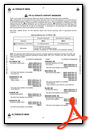
Weather Minimums

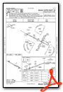
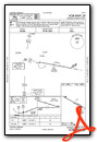
Instrument Approach Procedure (IAP) Charts


Nearby Airports with Instrument Procedures
| ID | Name | Heading / Distance | ||
|---|---|---|---|---|
 |
KANW | Ainsworth Regional Airport | 034° | 45.0 |
|
KLBF | North Platte Regional/Lee Bird Field Airport | 185° | 50.4 |
|
KBBW | Broken Bow Municipal/Keith Glaze Field Airport | 126° | 52.3 |
|
KVTN | Miller Field Airport | 001° | 53.6 |
|
KRBE | Rock County Airport | 050° | 57.6 |
|
KBUB | Cram Field Airport | 099° | 64.6 |
|
KGTE | Gothenburg Municipal Airport | 162° | 65.1 |
|
KCZD | Cozad Municipal Airport | 158° | 70.4 |
|
KOGA | Searle Field Airport | 227° | 74.0 |
|
KODX | Evelyn Sharp Field Airport | 105° | 75.4 |
|
8V2 | Stuart-Atkinson Municipal Airport | 061° | 77.1 |
|
KSUO | Rosebud Sioux Tribal Airport | 350° | 78.8 |
Airport Images
Do you have a recent image of this airport? Upload it here!


