Login
Register


8V2
Stuart-Atkinson Municipal Airport
Official FAA Data Effective 2026-01-22 0901Z
Chart Supplement

VFR Chart of 8V2
Sectional Charts at SkyVector.com
IFR Chart of 8V2
Enroute Charts at SkyVector.com
Location Information for 8V2
Coordinates: N42°33.76' / W99°2.33'Located 03 miles NW of Atkinson, Nebraska on 241 acres of land. View all Airports in Nebraska.
Estimated Elevation is 2131 feet MSL.
Operations Data
|
|
Airport Communications
| CTAF: | 122.900 |
|---|---|
| AWOS-3 at ONL (16.5 E): | 121.125 402-336-4834 |
| AWOS-3 at ANW (42.4 W): | 118.325 402-387-2329 |
| AWOS-3P at AGZ (44.5 NE): | 128.325 605-384-3922 |
- APCH/DEP SVC PRVDD BY MINNEAPOLIS ARTCC ON FREQS 128.0/257.95 (O'NEILL RCAG).
Nearby Navigation Aids
|
| ||||||||||||||||||||||||||||||||||||||||||||||||||||||


Runway 11/29
| Dimensions: | 3900 x 60 feet / 1189 x 18 meters | |
|---|---|---|
| Surface: | Concrete in Good Condition | |
| Weight Limits: | S-12 | |
| Edge Lighting: | Medium Intensity | |
| Runway 11 | Runway 29 | |
| Coordinates: | N42°33.92' / W99°2.81' | N42°33.60' / W99°2.06' |
| Elevation: | 2131.3 | 2126.1 |
| Traffic Pattern: | Left | Left |
| Runway Heading: | 120° True | 300° True |
| Markings: | Non-Precision Instrument in good condition. | Non-Precision Instrument in good condition. |
| Glide Slope Indicator | P2L (3.00° Glide Path Angle) | P2L (3.00° Glide Path Angle) |
| REIL: | Yes | Yes |
Runway 05/23
| Dimensions: | 2970 x 100 feet / 905 x 30 meters NARROWED TO 100', CENTERLINE STAYED THE SAME. | |
|---|---|---|
| Surface: | Turf in Fair Condition | |
| Runway 05 | Runway 23 | |
| Coordinates: | N42°33.64' / W99°2.47' | N42°33.88' / W99°1.90' |
| Elevation: | 2121.8 | 2127.4 |
| Traffic Pattern: | Left | Left |
| Runway Heading: | 60° True | 240° True |
| Markings: | Non-Standard | Non-Standard |
Services Available
| Fuel: | 100LL (blue) |
|---|---|
| Transient Storage: | Tiedowns |
| Airframe Repair: | NONE |
| Engine Repair: | NONE |
| Bottled Oxygen: | NONE |
| Bulk Oxygen: | NONE |
| Other Services: | CROP DUSTING SERVICES |
Ownership Information
| Ownership: | Publicly owned | |
|---|---|---|
| Owner: | STUART ATKINSON AIRPORT AUTH | |
| P.O. BOX 265 | ||
| STUART, NE 68780-0265 | ||
| 402-340-0388 | ||
| Manager: | JACK FLANNERY | |
| PO BOX 83 | ||
| ATKINSON, NE 68713-0083 | ||
| 402-340-0388 | ||
Other Remarks
- FOR CD CTC MINNEAPOLIS ARTCC AT 651-463-5588.
- NSTD MKGS RY 05/23 MARKED WITH YELLOW CONES.
- 0LL FOR FUEL CALL (402) 925-5527 OR (402) 340-0388.
- ACTVT REIL RWY 11 & 29; PAPI RWY 11/29; MIRL RWY 11/29 PRESET MED INTST SS-SR, TO INCR INTST & ACTVT- CTAF.
Weather Minimums

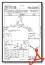
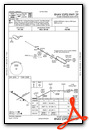
Instrument Approach Procedure (IAP) Charts
Nearby Airports with Instrument Procedures
| ID | Name | Heading / Distance | ||
|---|---|---|---|---|
 |
KONL | The O'Neill Municipal-John L Baker Field Airport | 109° | 16.6 |
|
KRBE | Rock County Airport | 271° | 23.5 |
|
KANW | Ainsworth Regional Airport | 271° | 42.3 |
|
9D1 | Gregory Municipal/Flynn Field Airport | 337° | 42.7 |
|
KAGZ | Wagner Municipal Airport | 047° | 44.5 |
|
KBUB | Cram Field Airport | 186° | 47.4 |
|
6K3 | Creighton Municipal Airport | 095° | 51.5 |
|
4V9 | Antelope County Airport | 120° | 52.0 |
|
KODX | Evelyn Sharp Field Airport | 176° | 56.5 |
|
KICR | Winner Regional Airport | 324° | 60.9 |
|
KBVN | Albion Municipal Airport | 138° | 66.5 |
|
8V3 | Parkston Municipal Airport | 043° | 67.3 |
Airport Images
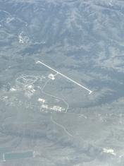
By: Big Orange Bird


