Login
Register


WRL
Worland Municipal Airport
Official FAA Data Effective 2026-02-19 0901Z
Chart Supplement

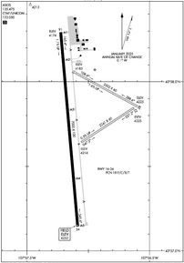
KWRL Airport Diagram
VFR Chart of KWRL
Sectional Charts at SkyVector.com
IFR Chart of KWRL
Enroute Charts at SkyVector.com
Location Information for KWRL
Coordinates: N43°57.77' / W107°57.03'Located 03 miles S of Worland, Wyoming on 690 acres of land. View all Airports in Wyoming.
Surveyed Elevation is 4251 feet MSL.
Operations Data
|
|
Airport Communications
| ASOS: | 135.475 Tel. 307-347-4217 |
|---|---|
| UNICOM: | 123.050 |
| CTAF: | 123.050 |
| AWOS-3PT at HSG (23.9 SW): | 121.125 307-867-2033 |
| AWOS-3PT at TBX (32.4 SW): | 119.150 307-709-4487 |
| ASOS at GEY (33.8 N): | 135.325 307-765-9406 |
- APCH/DEP CTL SVC PRVDD BY SALT LAKE ARTCC (ZLC) ON FREQS 133.25/285.6 (BOYSEN RCAG).
Nearby Navigation Aids
|
| ||||||||||||||||||||||||||||||||||||

Runway 16/34
| Dimensions: | 7000 x 100 feet / 2134 x 30 meters | |
|---|---|---|
| Surface: | Asphalt / Porous Friction Course in Good Condition | |
| Weight Limits: | 18 /F/C/X/T, S-50, D-70 | |
| Edge Lighting: | Medium Intensity | |
| Runway 16 | Runway 34 | |
| Coordinates: | N43°58.29' / W107°57.22' | N43°57.14' / W107°57.09' |
| Elevation: | 4174.1 | 4251.7 |
| Traffic Pattern: | Left | Left |
| Runway Heading: | 175° True | 355° True |
| Declared Distances: | TORA:7000 TODA:7000 ASDA:7000 LDA:7000 | TORA:7000 TODA:7000 ASDA:7000 LDA:7000 |
| Markings: | Non-Precision Instrument in good condition. | Non-Precision Instrument in good condition. |
| Glide Slope Indicator | P4L (3.00° Glide Path Angle) | P4L (3.00° Glide Path Angle) |
| REIL: | Yes | Yes |
Runway 10/28
| Dimensions: | 2502 x 60 feet / 763 x 18 meters | |
|---|---|---|
| Surface: | Turf in Fair Condition | |
| Runway 10 | Runway 28 | |
| Coordinates: | N43°58.05' / W107°57.10' | N43°57.85' / W107°56.60' |
| Elevation: | 4184.9 | 4225.0 |
| Traffic Pattern: | Left | Left |
| Runway Heading: | 118° True | 298° True |
| Declared Distances: | TORA:2501 TODA:2501 ASDA:2501 LDA:2501 | TORA:2501 TODA:2501 ASDA:2501 LDA:2501 |
| Obstacles: | 10 ft Brush 153 ft from runway, 15 ft right of center | |
Runway 04/22
| Dimensions: | 2241 x 60 feet / 683 x 18 meters | |
|---|---|---|
| Surface: | Turf in Fair Condition | |
| Runway 04 | Runway 22 | |
| Coordinates: | N43°57.64' / W107°57.06' | N43°57.84' / W107°56.63' |
| Elevation: | 4213.5 | 4225.1 |
| Traffic Pattern: | Left | Left |
| Runway Heading: | 57° True | 237° True |
| Declared Distances: | TORA:2241 TODA:2241 ASDA:2241 LDA:2241 | TORA:2241 TODA:2241 ASDA:2241 LDA:2241 |
Services Available
| Fuel: | 100LL (blue), Jet-A |
|---|---|
| Transient Storage: | Hangars,Tiedowns |
| Airframe Repair: | NONE |
| Engine Repair: | NONE |
| Bottled Oxygen: | NONE |
| Bulk Oxygen: | NONE |
| Other Services: | CROP DUSTING SERVICES,AIR AMBULANCE SERVICES,PILOT INSTRUCTION |
Ownership Information
| Ownership: | Publicly owned | |
|---|---|---|
| Owner: | CITY OF WORLAND | |
| P.O. BOX 226 | ||
| WORLAND, WY 82401 | ||
| 307-347-2486 | ||
| Manager: | LYNN MURDOCH | |
| 1438 AIRPORT ROAD | ||
| WORLAND, WY 82401 | ||
| 307-347-8977 | ||
Other Remarks
- WIND PERMITTING LAND RY 16.
- RYS 04/22 & 10/28 CLSD OCT 30 - MAR 30 YEARLY.
- FOR CD IF UNA TO CTC ON FSS FREQ, CTC SALT LAKE ARTCC AT 801-320-2568.
- 0LL FUEL AVBL VIA 24 HR SELF SERVE CREDIT CARD.
- ACTVT REIL RWY 16 & 34; PAPI RWY 34; MIRL RWY 16/34 - CTAF. PAPI RWY 16 OPR CONSLY.
Weather Minimums


Instrument Approach Procedure (IAP) Charts


Nearby Airports with Instrument Procedures
| ID | Name | Heading / Distance | ||
|---|---|---|---|---|
 |
KHSG | Hot Springs County Airport | 232° | 24.2 |
|
KGEY | South Big Horn County Airport | 350° | 33.8 |
|
KCOD | Yellowstone Regional Airport | 306° | 57.1 |
|
KRIW | Central Wyoming Regional Airport | 202° | 58.3 |
|
KBYG | Johnson County Airport | 064° | 58.7 |
|
U68 | North Big Horn County Airport | 339° | 60.8 |
|
KSHR | Sheridan County Airport | 040° | 63.9 |
|
KPOY | Powell Municipal Airport | 326° | 65.3 |
|
KLND | Hunt Field Airport | 206° | 76.8 |
|
KDUB | Dubois Municipal Airport | 252° | 79.7 |
|
KCPR | Casper/Natrona County International Airport | 133° | 90.8 |
|
KGCC | Northeast Wyoming Regional Airport | 076° | 106.7 |
Fuel Providers

Airport Images
Do you have a recent image of this airport? Upload it here!


