Login
Register


CPR
Casper/Natrona County International Airport
Official FAA Data Effective 2026-02-19 0901Z
Chart Supplement

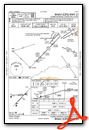
KCPR Airport Diagram

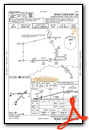
VFR Chart of KCPR
Sectional Charts at SkyVector.com
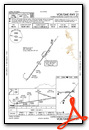
IFR Chart of KCPR
Enroute Charts at SkyVector.com
Location Information for KCPR
Coordinates: N42°54.35' / W106°27.82'Located 07 miles NW of Casper, Wyoming on 5150 acres of land. View all Airports in Wyoming.
Surveyed Elevation is 5344 feet MSL.
Operations Data
|
|
Airport Communications
| ATIS: | 126.15 |
|---|---|
| ASOS: | Tel. 307-452-0316 |
| CASPER TOWER: | 118.3 257.8 |
| CASPER GROUND: | 121.9 |
| CASPER APPROACH: | 119.0 120.65 354.1 |
| CASPER DEPARTURE: | 119.0 120.65 354.1 |
| IC: | 120.65 |
| CLEARANCE DELIVERY: | 121.9 257.8 |
| CTAF: | 118.300 |
| UNICOM: | 122.950 |
| ASOS at DGW (47.9 E): | 135.225 307-358-4448 |
| AWOS-3PT at TBX (84.6 NW): | 119.150 307-709-4487 |
| AWOS-3PT at EAN (84.6 SE): | 121.125 307-322-1557 |
- APCH/DEP CTL SVC PRVDD BY DENVER ARTCC (ZDV) ON FREQS 135.6/363.025 (CASPER RCAG) WHEN CASPER APCH CTL (CPR) CLSD.
- FREQ 121.5 NOT AVBL.
- COMMUNICATIONS PRVDD BY CASPER RADIO ON FREQS 122.6 (CASPER RCO).
Nearby Navigation Aids
|
| ||||||||||||||||||||||||||||||||||||||||||


Runway 03/21
| Dimensions: | 10165 x 150 feet / 3098 x 46 meters | |
|---|---|---|
| Surface: | Asphalt / Grooved in Good Condition | |
| Weight Limits: | S-120, D-250, ST-550, DT-1120
PCR VALUE: 1190/F/C/X/T
| |
| Edge Lighting: | High Intensity | |
| Runway 03 | Runway 21 | |
| Coordinates: | N42°53.60' / W106°28.50' | N42°54.81' / W106°26.92' |
| Elevation: | 5324.2 | 5326.1 |
| Traffic Pattern: | Left | Left |
| Runway Heading: | 44° True | 224° True |
| Declared Distances: | TORA:10165 TODA:10165 ASDA:10165 LDA:10165 | TORA:10165 TODA:10165 ASDA:10165 LDA:10165 |
| Markings: | Precision Instrument in good condition. | Precision Instrument in good condition. |
| Glide Slope Indicator | P4R (3.00° Glide Path Angle) | V4L (3.00° Glide Path Angle) |
| RVR Equipment | Touchdown | Rollout |
| Approach Lights: | MALSR 1,400 Foot Medium-intensity Approach Lighting System with runway alignment indicator lights. | |
| REIL: | Yes | |
Runway 08/26
| Dimensions: | 8679 x 150 feet / 2645 x 46 meters | |
|---|---|---|
| Surface: | Asphalt / Grooved in Fair Condition | |
| Weight Limits: | S-120, D-250, ST-416, DT-946
PCR VALUE: 1000/F/D/X/T
| |
| Edge Lighting: | High Intensity | |
| Runway 08 | Runway 26 | |
| Coordinates: | N42°54.51' / W106°28.91' | N42°54.54' / W106°26.97' |
| Elevation: | 5343.8 | 5323.5 |
| Runway Heading: | 89° True | 269° True |
| Declared Distances: | TORA:8679 TODA:8679 ASDA:8679 LDA:8679 | TORA:8679 TODA:8679 ASDA:8679 LDA:8679 |
| Markings: | Precision Instrument in good condition. | Precision Instrument in good condition. |
| Glide Slope Indicator | P4R (3.00° Glide Path Angle) | P4R (3.00° Glide Path Angle) |
| RVR Equipment | Touchdown | Rollout |
| Approach Lights: | MALSR 1,400 Foot Medium-intensity Approach Lighting System with runway alignment indicator lights. | |
| REIL: | Yes | |
Services Available
| Fuel: | 100LL (blue), Jet-A |
|---|---|
| Transient Storage: | Hangars,Tiedowns |
| Airframe Repair: | MAJOR |
| Engine Repair: | MAJOR |
| Bottled Oxygen: | HIGH/LOW |
| Bulk Oxygen: | HIGH/LOW |
| Other Services: | AIR FREIGHT SERVICES,AIR AMBULANCE SERVICES,AVIONICS,CARGO HANDLING SERVICES,CHARTER SERVICE,PILOT INSTRUCTION,AIRCRAFT RENTAL,AIRCRAFT SALES,ANNUAL SURVEYING |
Ownership Information
| Ownership: | Publicly owned | |
|---|---|---|
| Owner: | COUNTY BOARD OF COMMISSIONERS | |
| 8500 AIRPORT PARKWAY, SUITE 208 | ||
| CASPER, WY 82604 | ||
| 307-472-6688 | ||
| Manager: | GLENN JANUSKA | |
| 8500 AIRPORT PARKWAY, SUITE 208 | ||
| CASPER, WY 82604 | ||
| 307-472-6688 | ||
Other Remarks
- EMERG PWR AVBL RWY 08/26 & 03/21.
- RWY 08/26 & 03/21 HAVE LGTD DIST RMNG SIGNS.
- 225 FT CRANE 1 NM NE OF ARPT.
- RWYS CLSD TO FSL, TGL, AND PLA ACFT MORE THAN 250000 LBS EXC FOR 4 HRS PPR 307-995-3949.
- FOR CD CTC CASPER APCH AT 307-472-8940, WHEN APCH CLSD CTC DENVER ARTCC AT 303-651-4257.
- ATC-CTL. WHEN ATCT CLSD ACTVT MALSR RWY 03 & 08; REIL RWY 21; PAPI RWY 03 & 26; HIRL RWY 03/21 & 08/26; TWY LGTS - CTAF.
Weather Minimums


Instrument Approach Procedure (IAP) Charts


Departure Procedure (DP) Charts


Nearby Airports with Instrument Procedures
| ID | Name | Heading / Distance | ||
|---|---|---|---|---|
 |
KDGW | Converse County Airport | 097° | 48.0 |
|
KRWL | Rawlins Municipal/Harvey Field Airport | 206° | 73.7 |
|
KEAN | Phifer Airfield Airport | 126° | 85.1 |
|
KGUR | Camp Guernsey Airport | 116° | 86.1 |
|
KRIW | Central Wyoming Regional Airport | 276° | 88.4 |
|
KBYG | Johnson County Airport | 352° | 89.2 |
|
KSAA | Shively Field Airport | 190° | 89.2 |
|
KWRL | Worland Municipal Airport | 314° | 90.8 |
|
KGCC | Northeast Wyoming Regional Airport | 024° | 95.5 |
|
KHSG | Hot Springs County Airport | 300° | 97.3 |
|
KLND | Hunt Field Airport | 267° | 100.1 |
|
KLAR | Laramie Regional Airport | 159° | 101.9 |
Fuel Providers


We proudly offer fuel from:

US Dollar per US Gallon
Price Guaranteed by FBO
Airport Images
Do you have a recent image of this airport? Upload it here!


