Login
Register


RUE
Russellville Regional Airport
Official FAA Data Effective 2025-12-25 0901Z
Chart Supplement

VFR Chart of KRUE
Sectional Charts at SkyVector.com
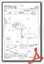
IFR Chart of KRUE
Enroute Charts at SkyVector.com
Location Information for KRUE
Coordinates: N35°15.56' / W93°5.56'Located 02 miles SE of Russellville, Arkansas on 317 acres of land. View all Airports in Arkansas.
Surveyed Elevation is 409 feet MSL.
Operations Data
|
|
Airport Communications
| ASOS: | 132.475 Tel. 479-968-2267 |
|---|---|
| CTAF: | 122.700 |
| UNICOM: | 122.700 |
| AWOS-2 at CXW (29.9 SE): | 118.775 501-358-6209 |
| AWOS-3 at CCA (37.5 NE): | 118.725 501-745-5000 |
| ASOS at HOT (46.9 S): | 119.925 501-624-7633 |
- APCH/DEP SVC PRVDD BY MEMPHIS ARTCC ON FREQS 128.475/377.15 (RUSSELLVILLE RCAG).
Nearby Navigation Aids
|
| ||||||||||||||||||||||||||||||||||||||||||||||||||||||


Runway 07/25
| Dimensions: | 5505 x 75 feet / 1678 x 23 meters | |
|---|---|---|
| Surface: | Asphalt in Good Condition | |
| Weight Limits: | S-32, D-46 | |
| Edge Lighting: | Medium Intensity | |
| Runway 07 | Runway 25 | |
| Coordinates: | N35°15.44' / W93°6.09' | N35°15.67' / W93°5.02' |
| Elevation: | 370.1 | 409.2 |
| Traffic Pattern: | Left | Left |
| Runway Heading: | 75° True | 255° True |
| Displaced Threshold: | 706 Feet | |
| Markings: | Non-Precision Instrument in good condition. | Non-Precision Instrument in good condition. |
| Glide Slope Indicator | P4L (3.00° Glide Path Angle) | P4L (4.00° Glide Path Angle) |
| REIL: | Yes | Yes |
| Obstacles: | 35 ft Tree 1475 ft from runway, 125 ft right of center | 78 ft Tree 1825 ft from runway, 115 ft right of center APCH SLOPE 29:1 TO DSPLCD THLD. |
Services Available
| Fuel: | 100LL (blue), Jet-A |
|---|---|
| Transient Storage: | Tiedowns OPN SHADE HNGRS, LIMITED AVAILABLILITY. |
| Airframe Repair: | NONE |
| Engine Repair: | NONE |
| Bottled Oxygen: | NONE |
| Bulk Oxygen: | NONE |
| Other Services: | AIR FREIGHT SERVICES,CROP DUSTING SERVICES,AIR AMBULANCE SERVICES,PILOT INSTRUCTION |
Ownership Information
| Ownership: | Publicly owned | |
|---|---|---|
| Owner: | CITY OF RUSSELLVILLE | |
| 203 S. COMMERCE STR | ||
| RUSSELLVILLE, AR 72801 | ||
| 479-968-2098 | ||
| Manager: | PATRICK KARP | |
| 1759 AIRPORT ROAD | ||
| RUSSELLVILLE, AR 72802 | ||
| 479-967-1227 | ||
Other Remarks
- FLOCKS OF MIGRATORY BIRDS INVOF ARPT.
- DEER ON & INVOF RY.
- FOR CD CTC MEMPHIS ARTCC AT 901-368-8453/8449.
- HELI SERVICE CENTER ON FLD.
- 0LL SELF SVC FUEL AVBL 24 HRS WITH CREDIT CARD (100 LL)
- DUSK-DAWN. ACTVT REIL RWYS 07 & 25; PAPI RWYS 07 & 25; MIRL 07/25 - CTAF.
Weather Minimums
Instrument Approach Procedure (IAP) Charts
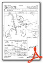
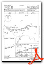
Nearby Airports with Instrument Procedures
| ID | Name | Heading / Distance | ||
|---|---|---|---|---|
 |
KMPJ | Petit Jean Park Airport | 128° | 11.6 |
|
32A | Danville Municipal Airport | 238° | 19.5 |
|
KBDQ | Morrilton Municipal Airport | 111° | 20.0 |
|
H35 | Clarksville Municipal Airport | 307° | 20.7 |
|
KCXW | Conway Regional Airport | 118° | 30.1 |
|
KCCA | Clinton Municipal Airport | 056° | 37.4 |
|
7M5 | Ozark/Franklin County Airport | 292° | 39.6 |
|
2A2 | Holley Mountain Airpark Airport | 055° | 41.1 |
|
4A5 | Searcy County Airport | 029° | 43.9 |
|
KHOT | Memorial Field Airport | 180° | 46.8 |
|
KORK | North Little Rock Municipal Airport | 121° | 48.6 |
|
KSUZ | Saline County Regional Airport | 142° | 50.2 |
Fuel Providers

Airport Images

By: japanjeff

By: Big Orange Bird


Comments
A rare 5 stars. This is what
A rare 5 stars. This is what GA airports around the world should strive. Covered tie down spots. Crew Car. 24 hour FBO. Ellie the airport dog. You name it they have it. The pilot lounge is great. Nation and Justice amongst the most helpful and knowledgeable around.
On arrival I was greeted and marshaled into the 'hollywood parking' spot. When it was time to leave I arrived before opening but Nation was at work 30 minutes early.
Inside the lobby is functional and interesting. I took pictures and took my time reading the pieces in the display case.
Easily the best GA airport overnight that I have made this year. KRUE.