Login
Register
S34
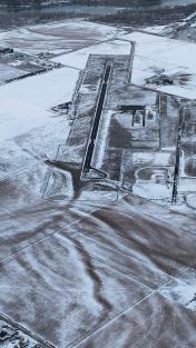
Plains Airport
Official FAA Data Effective 2026-01-22 0901Z
VFR Chart of S34
Sectional Charts at SkyVector.com
IFR Chart of S34
Enroute Charts at SkyVector.com
Location Information for S34
Coordinates: N47°28.41' / W114°54.42'Located 01 miles NW of Plains, Montana on 259 acres of land. View all Airports in Montana.
Surveyed Elevation is 2467 feet MSL.
Operations Data
|
|
Airport Communications
| AWOS-3PT: | 118.1 Tel. 406-826-5784 |
|---|---|
| CTAF: | 122.900 |
| ASOS at MLP (30.0 W): | 135.475 208-744-1721 |
| AWOS-3 at 7S0 (33.2 E): | 119.925 406-676-2967 |
| ATIS at MSO (47.2 SE): | 126.65 |
Nearby Navigation Aids
|
| ||||||||||||||||||||||||||||||||||||||||||||||||
Runway 13/31
| Dimensions: | 4650 x 75 feet / 1417 x 23 meters | |
|---|---|---|
| Surface: | Asphalt in Good Condition | |
| Weight Limits: | S-12, D-18 | |
| Edge Lighting: | Medium Intensity | |
| Runway 13 | Runway 31 | |
| Coordinates: | N47°28.71' / W114°54.77' | N47°28.11' / W114°54.08' |
| Elevation: | 2461.5 | 2414.9 |
| Traffic Pattern: | Left | Left |
| Runway Heading: | 142° True | 322° True |
| Markings: | Basic in good condition. | Basic in good condition. |
| Glide Slope Indicator | P2L (3.00° Glide Path Angle) | |
Services Available
| Fuel: | NONE |
|---|---|
| Transient Storage: | Tiedowns |
| Airframe Repair: | NONE |
| Engine Repair: | NONE |
| Bottled Oxygen: | NONE |
| Bulk Oxygen: | NONE |
| Other Services: | PILOT INSTRUCTION |
Ownership Information
| Ownership: | Publicly owned | |
|---|---|---|
| Owner: | SANDERS COUNTY | |
| PO BOX 519 | ||
| THOMPSON FALLS, MT 59873 | ||
| 406-826-3605 | ||
| Manager: | RANDY GARRISON | |
| PO BOX 988 | ||
| PLAINS, MT 59859 | ||
| 406-370-6179 | ||
Other Remarks
- FOR CD CTC SALT LAKE ARTCC AT 801-320-2568.
- ACTVT PAPI RWY 31; MIRL RWY 13/31 - CTAF.
Nearby Airports with Instrument Procedures
| ID | Name | Heading / Distance | ||
|---|---|---|---|---|
 |
8S1 | Polson Airport | 065° | 32.2 |
 |
7S0 | Ronan Airport | 079° | 33.3 |
 |
KMSO | Missoula Montana Airport | 134° | 47.3 |
 |
S59 | Libby Airport | 334° | 54.0 |
 |
KGPI | Glacier Park International Airport | 027° | 56.7 |
 |
32S | Stevensville Airport | 148° | 66.9 |
 |
KCOE | Coeur D'Alene/Pappy Boyington Field Airport | 283° | 79.7 |
 |
KHRF | Ravalli County Airport | 155° | 79.8 |
 |
KSZT | Sandpoint Airport | 307° | 83.2 |
 |
65S | Boundary County Airport | 323° | 93.6 |
 |
KSFF | Felts Field Airport | 278° | 98.9 |
 |
KPUW | Pullman/Moscow Regional Airport | 244° | 100.5 |


