Login
Register
S45
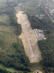
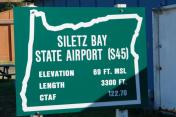
Siletz Bay State Airport
Official FAA Data Effective 2025-12-25 0901Z
VFR Chart of S45
Sectional Charts at SkyVector.com
IFR Chart of S45
Enroute Charts at SkyVector.com
Location Information for S45
Coordinates: N44°52.61' / W124°1.71'Located 01 miles SE of Gleneden Beach, Oregon on 98 acres of land. View all Airports in Oregon.
Surveyed Elevation is 69 feet MSL.
Operations Data
|
|
Airport Communications
| CTAF: | 122.700 |
|---|---|
| UNICOM: | 122.700 |
| AWOS-3 at ONP (17.8 S): | 133.9 541-867-4175 |
| AWOS-3PT at TMK (33.9 N): | 120.0 503-842-8792 |
| AWOS-3PT at CVO (38.7 SE): | 135.775 541-754-0081 |
Nearby Navigation Aids
|
| ||||||||||||||||||||||||||||||||||||||||||||||||
Runway 17/35
| Dimensions: | 3297 x 60 feet / 1005 x 18 meters | |
|---|---|---|
| Surface: | Asphalt in Fair Condition | |
| Weight Limits: | S-11 | |
| Edge Lighting: | Medium Intensity | |
| Runway 17 | Runway 35 | |
| Coordinates: | N44°52.87' / W124°1.64' | N44°52.34' / W124°1.79' |
| Elevation: | 59.3 | 69.2 |
| Traffic Pattern: | Right | Left |
| Runway Heading: | 191° True | 11° True |
| Markings: | Basic in fair condition. | Basic in fair condition. |
| Obstacles: | 88 ft Trees 960 ft from runway, 125 ft left of center 35' TREES 0-200' FM RY END 105-120' L OF CNTRLN. |
23 ft Trees 323 ft from runway, 69 ft right of center RWY 35 10 FT BRUSH AT 75-200 FT FM RWY END & 90-125 FT L OF CNTRLN. |
Services Available
| Fuel: | NONE |
|---|---|
| Transient Storage: | Tiedowns |
| Airframe Repair: | NONE |
| Engine Repair: | NONE |
| Bottled Oxygen: | NONE |
| Bulk Oxygen: | NONE |
Ownership Information
| Ownership: | Publicly owned | |
|---|---|---|
| Owner: | OREGON DEPT. OF AVIATION | |
| 3040 25TH ST SE | ||
| SALEM, OR 97302-1125 | ||
| 503-378-4880 | ||
| Manager: | STATE AIRPORTS MANAGER | |
| 3040 25TH ST SE | ||
| SALEM, OR 97302-1125 | ||
| 503-378-4880 | ||
Other Remarks
- WILDLIFE ON AND INVOF OF AIRPORT.
- FOR CD CTC SEATTLE ARTCC AT 253-351-3694.
- SFC CONDS NOT RPRTD.
- MIRL RY 17/35 PRESET LOW INTST; ACTVT HIGHER INTST - CTAF.
- UNICOM ATTENDED IRREGULARLY.
Nearby Airports with Instrument Procedures
| ID | Name | Heading / Distance | ||
|---|---|---|---|---|
 |
KONP | Newport Municipal Airport | 184° | 17.8 |
 |
KTMK | Tillamook Airport | 015° | 33.7 |
 |
KCVO | Corvallis Municipal Airport | 125° | 39.0 |
 |
KMMV | Mc Minnville Municipal Airport | 063° | 42.5 |
 |
KSLE | Mcnary Field Airport | 087° | 43.8 |
 |
S12 | Albany Municipal Airport | 108° | 43.8 |
 |
KEUG | Mahlon Sweet Field Airport | 141° | 57.2 |
 |
KUAO | Aurora State Airport | 067° | 58.0 |
 |
KHIO | Portland-Hillsboro Airport | 048° | 60.7 |
 |
77S | Hobby Field Airport | 141° | 71.8 |
 |
KSPB | Scappoose Airport | 042° | 72.9 |
 |
KVUO | Pearson Field Airport | 052° | 73.3 |


