Login
Register


S77
Magee Airport
Official FAA Data Effective 2026-01-22 0901Z
Chart Supplement

VFR Chart of S77
Sectional Charts at SkyVector.com
IFR Chart of S77
Enroute Charts at SkyVector.com
Location Information for S77
Coordinates: N47°50.49' / W116°15.12'Located 23 miles NE of Coeur D'Alene, Idaho on 20 acres of land. View all Airports in Idaho.
Estimated Elevation is 3002 feet MSL.
Operations Data
|
|
Airport Communications
| CTAF: | 122.900 |
|---|---|
| AWOS-3PT at COE (23.2 W): | 135.075 208-772-8215 |
| AWOS-2 at SZT (30.1 NW): | 135.425 208-263-3074 |
| ASOS at MLP (33.7 SE): | 135.475 208-744-1721 |
Nearby Navigation Aids
|
| ||||||||||||||||||||||||||||||||||||||||||||||||||||||


Runway 01/19
RWY 01/19 FIRST 500 FT OF RWY 19 CLSD APR 1ST - JUL 15TH DUE TO WATER ON RWY. | ||
| Dimensions: | 2200 x 150 feet / 671 x 46 meters | |
|---|---|---|
| Surface: | Turf in Good Condition FIRST 300 FT OF N END/RWY 19 IS VERY ROUGH. | |
| Runway 01 | Runway 19 | |
| Traffic Pattern: | Left | Left |
| Displaced Threshold: | 300 Feet | |
| Obstacles: | 12 ft Sign 40 ft from runway, 80 ft left of center +14 FT ROAD AT 65 FT ON CNTRLN. |
15 ft Brush 0 ft from runway, 120 ft right of center |
Services Available
| Fuel: | NONE |
|---|---|
| Transient Storage: | Tiedowns |
| Airframe Repair: | NONE |
| Engine Repair: | NONE |
| Bottled Oxygen: | NONE |
| Bulk Oxygen: | NONE |
Ownership Information
| Ownership: | Publicly owned | |
|---|---|---|
| Owner: | STATE OF IDAHO/ITD-DIV OF AERONAUTI | |
| BOX 7129 | ||
| BOISE, ID 83707-1129 | ||
| 208-334-8775 | ||
| Manager: | DIV OF AERONAUTICS | |
| BOX 7129 | ||
| BOISE, ID 83707-1129 | ||
| 208-334-8775 | ||
Other Remarks
- NO WINTER MAINT.
- RCMD LAND RWY 19; TKOF RWY 01 WHEN WIND CONDS PERMIT.
- HEAVY SNOWMOBLILE ACTIVITY DURING WINTER MONTHS.
- FOR CD CTC SEATTLE ARTCC AT 253-351-3694.
- 01/19 EDGES & THRS MARKED WITH WHITE ROCKS.
Nearby Airports with Instrument Procedures
| ID | Name | Heading / Distance | ||
|---|---|---|---|---|
 |
KCOE | Coeur D'Alene/Pappy Boyington Field Airport | 260° | 23.3 |
|
KSZT | Sandpoint Airport | 335° | 30.2 |
|
S59 | Libby Airport | 048° | 40.6 |
|
KSFF | Felts Field Airport | 258° | 44.4 |
|
KDEW | Deer Park Airport | 279° | 48.1 |
|
65S | Boundary County Airport | 358° | 53.1 |
|
KGEG | Spokane International Airport | 256° | 53.7 |
|
KSKA | Fairchild AFB Airport | 257° | 58.5 |
|
KPUW | Pullman/Moscow Regional Airport | 208° | 74.8 |
|
8S1 | Polson Airport | 095° | 84.1 |
|
KGPI | Glacier Park International Airport | 069° | 85.1 |
|
7S0 | Ronan Airport | 099° | 88.7 |
Airport Images
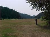
By: oneniner

By: oneniner


