Login
Register


SBM
Sheboygan County Memorial International Airport
Official FAA Data Effective 2026-02-19 0901Z
Chart Supplement

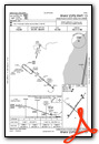
KSBM Airport Diagram

VFR Chart of KSBM
Sectional Charts at SkyVector.com
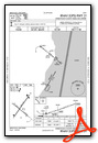
IFR Chart of KSBM
Enroute Charts at SkyVector.com
Location Information for KSBM
Coordinates: N43°46.19' / W87°51.10'Located 03 miles NW of Sheboygan, Wisconsin on 737 acres of land. View all Airports in Wisconsin.
Surveyed Elevation is 755 feet MSL.
Operations Data
|
|
Airport Communications
| ASOS: | 118.425 Tel. 920-467-0744 |
|---|---|
| MILWAUKEE APPROACH: | 127.375 263.075 |
| MILWAUKEE DEPARTURE: | 127.375 263.075 |
| CLEARANCE DELIVERY: | 127.375 |
| CTAF: | 122.700 |
| UNICOM: | 122.700 |
| AWOS-3PT at MTW (22.8 N): | 123.775 920-682-1164 |
| AWOS-3 at ETB (24.2 SW): | 120.0 262-334-6161 |
| ASOS at FLD (27.7 W): | 134.0 920-922-4444 |
- CLNC DEL SVC PRVDD BY MILWAUKEE ATCT ON FREQ 127.375
- APCH/DEP SVC PRVDD BY MILWAUKEE ATCT ON FREQ 127.375/263.075.
Nearby Navigation Aids
|
| ||||||||||||||||||||||||||||||||||||||||||||||||||||||||||||


Runway 04/22
| Dimensions: | 6801 x 100 feet / 2073 x 30 meters | |
|---|---|---|
| Surface: | Concrete / Grooved in Good Condition | |
| Weight Limits: | S-45, D-98 | |
| Edge Lighting: | High Intensity | |
| Runway 04 | Runway 22 | |
| Coordinates: | N43°45.79' / W87°51.52' | N43°46.71' / W87°50.63' |
| Elevation: | 743.9 | 742.6 |
| Traffic Pattern: | Left | Left |
| Runway Heading: | 35° True | 215° True |
| Markings: | Precision Instrument in fair condition. | Precision Instrument in fair condition. |
| Glide Slope Indicator | P4L (3.00° Glide Path Angle) | P4L (3.00° Glide Path Angle) |
| Approach Lights: | MALSR 1,400 Foot Medium-intensity Approach Lighting System with runway alignment indicator lights. | |
| REIL: | Yes | |
Runway 13/31
| Dimensions: | 5002 x 75 feet / 1525 x 23 meters | |
|---|---|---|
| Surface: | Asphalt in Excellent Condition | |
| Weight Limits: | S-30, D-72 | |
| Edge Lighting: | Medium Intensity | |
| Runway 13 | Runway 31 | |
| Coordinates: | N43°46.36' / W87°51.58' | N43°45.84' / W87°50.70' |
| Elevation: | 755.3 | 739.8 |
| Traffic Pattern: | Left | Left |
| Runway Heading: | 129° True | 309° True |
| Markings: | Non-Precision Instrument in fair condition. | Non-Precision Instrument in fair condition. |
| Glide Slope Indicator | P4L (3.00° Glide Path Angle) | P4L (3.00° Glide Path Angle) UNUSBL BYD 4 DEGS RIGHT OF CNTRLN. |
| Obstacles: | 56 ft Trees 1680 ft from runway, 365 ft right of center | 57 ft Trees 1800 ft from runway, 440 ft right of center |
Services Available
| Fuel: | 100LL (blue), Jet A+ |
|---|---|
| Transient Storage: | Hangars,Tiedowns |
| Airframe Repair: | MAJOR |
| Engine Repair: | MAJOR |
| Bottled Oxygen: | NONE |
| Bulk Oxygen: | NONE |
Ownership Information
| Ownership: | Publicly owned | |
|---|---|---|
| Owner: | SHEBOYGAN COUNTY | |
| N6193 RESOURCE DRIVE | ||
| SHEBOYGAN FALLS, WI 53085 | ||
| 920-467-2978 | ||
| Manager: | MATTHEW GRENOBLE | |
| N6193 RESOURCE DR. | ||
| SHEBOYGAN FALLS, WI 53085 | ||
| 920-467-2978 | ||
Other Remarks
- ULTRALIGHT ACTVTY ON & IN VCNTY OF ARPT.
- WATERFOWL & DEER ON & INVOF ARPT.
- GCO AVBL ON FREQ 121.725 THRU FLT SVCS.
- US CUST AND BDR PROTECTION, PPR US CSTMS SVC MON-FRI 1100 - 1900 CALL 920-335-2225.
- 0LL 24 HR FUEL AVBL WITH CREDIT CARD.
- ACTVT MALSR RWY 22; REIL RWY 04; PAPI RWY 04 & 22 - CTAF. HIRL RWY 04/22 & MIRL RWY 13/31 PRESET TO LOW SS-SR; TO INCR INTST & ACTVT - CTAF. PAPI RWY 13 & 31 OPRS CONSLY.
Weather Minimums


Instrument Approach Procedure (IAP) Charts


Nearby Airports with Instrument Procedures
| ID | Name | Heading / Distance | ||
|---|---|---|---|---|
 |
8D1 | New Holstein Municipal Airport | 312° | 15.5 |
|
KMTW | Manitowoc County Airport | 018° | 22.8 |
|
KETB | West Bend Municipal Airport | 210° | 24.1 |
|
KFLD | Fond Du Lac County Airport | 270° | 27.7 |
|
KOSH | Wittman Regional Airport | 293° | 33.2 |
|
KHXF | Hartford Municipal Airport | 223° | 34.4 |
|
KMWC | Lawrence J Timmerman Airport | 191° | 40.4 |
|
KATW | Appleton International Airport | 315° | 41.1 |
|
KUNU | Dodge County Airport | 241° | 42.5 |
|
KGRB | Green Bay/Austin Straubel International Airport | 344° | 44.5 |
|
KUES | Waukesha County Airport | 201° | 46.9 |
|
KMKE | General Mitchell International Airport | 182° | 49.4 |
Airport Images

By: Shalinij


