Login
Register


ATW
Appleton International Airport
Official FAA Data Effective 2026-02-19 0901Z
Chart Supplement

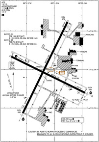
KATW Airport Diagram
VFR Chart of KATW
Sectional Charts at SkyVector.com
IFR Chart of KATW
Enroute Charts at SkyVector.com
Location Information for KATW
Coordinates: N44°15.49' / W88°31.14'Located 03 miles W of Appleton, Wisconsin on 1638 acres of land. View all Airports in Wisconsin.
Surveyed Elevation is 918 feet MSL.
Operations Data
|
|
Airport Communications
| ATIS: | 127.15 |
|---|---|
| AWOS-3: | Tel. 920-832-2597 |
| APPLETON TOWER: | 119.6 |
| APPLETON GROUND: | 121.7 |
| GREEN BAY APPROACH: | 126.3 338.2 |
| GREEN BAY DEPARTURE: | 126.3 338.2 |
| UNICOM: | 122.950 |
| CTAF: | 119.600 |
| ATIS at OSH (16.5 S): | 125.9 |
| ASOS at OSH (17.6 S): | 920-426-1644 |
| ASOS at GRB (21.5 NE): | 920-204-7824 |
- APCH/DEP SVC PRVDD BY MINNEAPOLIS ARTCC (ZMP) ON FREQS 126.3 (APPLETON RCAG)/317.7 (MOSINEE RCAG) WHEN GREEN BAY APCH CLSD.
Nearby Navigation Aids
|
| ||||||||||||||||||||||||||||||||||||||||||||||||||||||


Runway 03/21
| Dimensions: | 8003 x 150 feet / 2439 x 46 meters | |
|---|---|---|
| Surface: | Concrete / Grooved in Good Condition | |
| Weight Limits: | S-120, D-250, ST-524, DT-1043
PCR VALUE: 1000/R/C/W/T
| |
| Edge Lighting: | High Intensity | |
| Runway 03 | Runway 21 | |
| Coordinates: | N44°14.94' / W88°31.57' | N44°16.12' / W88°30.76' |
| Elevation: | 887.5 | 877.9 |
| Traffic Pattern: | Left | Left |
| Runway Heading: | 26° True | 206° True |
| Declared Distances: | TORA:8002 TODA:8002 ASDA:8002 LDA:8002 | TORA:8002 TODA:8002 ASDA:8002 LDA:8002 |
| Markings: | Precision Instrument in good condition. | Precision Instrument in good condition. |
| Glide Slope Indicator | P4L (3.00° Glide Path Angle) OPERATES CONTINUOUSLY. | P4L (3.00° Glide Path Angle) OPERATES CONTINUOUSLY. PAPI RESTRICTED BYD 8.5 DEG RGT OF COURSE. |
| RVR Equipment | Touchdown | Rollout |
| Approach Lights: | MALSR 1,400 Foot Medium-intensity Approach Lighting System with runway alignment indicator lights. | |
| REIL: | Yes | |
| Obstacles: | 56 ft Tree 2400 ft from runway, 200 ft left of center | 62 ft Tree 2600 ft from runway, 350 ft left of center |
Runway 12/30
| Dimensions: | 6502 x 150 feet / 1982 x 46 meters | |
|---|---|---|
| Surface: | Concrete / Grooved in Good Condition | |
| Weight Limits: | S-120, D-224, ST-360, DT-835
PCR VALUE: 730/R/C/W/T
| |
| Edge Lighting: | High Intensity | |
| Runway 12 | Runway 30 | |
| Coordinates: | N44°15.67' / W88°31.78' | N44°15.20' / W88°30.45' |
| Elevation: | 918.0 | 858.1 |
| Traffic Pattern: | Left | Left |
| Runway Heading: | 116° True | 296° True |
| Declared Distances: | TORA:6501 TODA:6501 ASDA:6501 LDA:6501 | TORA:6501 TODA:6501 ASDA:6501 LDA:6501 |
| Markings: | Precision Instrument in good condition. | Precision Instrument in good condition. |
| Glide Slope Indicator | P4L (3.00° Glide Path Angle) | P4L (3.00° Glide Path Angle) OPERATES CONTINUOUSLY. |
| Approach Lights: | MALSR 1,400 Foot Medium-intensity Approach Lighting System with runway alignment indicator lights. | |
| REIL: | Yes | |
| Obstacles: | 57 ft Tree 2800 ft from runway, 350 ft right of center | |
Services Available
| Fuel: | 100LL (blue), Jet-A |
|---|---|
| Transient Storage: | Hangars,Tiedowns |
| Airframe Repair: | MAJOR |
| Engine Repair: | MAJOR |
| Bottled Oxygen: | NONE |
| Bulk Oxygen: | HIGH/LOW |
| Other Services: | AIR FREIGHT SERVICES,AVIONICS,CHARTER SERVICE,PILOT INSTRUCTION,AIRCRAFT RENTAL,AIRCRAFT SALES |
Ownership Information
| Ownership: | Publicly owned | |
|---|---|---|
| Owner: | OUTAGAMIE COUNTY | |
| W6390 CHALLENGER DR-SUITE 201 | ||
| APPLETON, WI 54915 | ||
| 920-832-5267 | ||
| Manager: | ABE WEBER, AIRPORT DIRECTOR | |
| W6390 CHALLENGER DR-SUITE 201 | ||
| APPLETON, WI 54914-9119 | ||
| 920-832-5267 | ||
Other Remarks
- BIRDS & MIGRATORY WATERFOWL ON & INVOF ARPT.
- SNOW REMOVAL OPNS IN PROGRESS WINTER MONTHS. VEHICLE OPERATORS WILL BE MONITORING CTAF; ACFT LNDG/DEP APPLETON SHOULD USE CTAF WHEN ATCT CLSD.
- US CSTMS AND BORDER PROTECTION. PPR US CSTMS SVC MON-FRI 1300-2100Z (0800-1600 LOCAL) CALL 920-968-2348.
- WHEN ATCT CLSD, FOR CD CTC GREEN BAY APCH ON FREQ, IF UNA CTC MINNEAPOLIS ARTCC AT 651-463-5588.
- PERIODIC LIVE FIRE TRNG SOUTH SIDE OF ARPT.
- COML RAMP DEICING PADS ARE AVBL FOR LIVE ENG RUN OPN DRG DEICING.
- WHEN ATCT CLSD HIRL RWY 03/21 PRESET ON LOW INTST; TO INCR INTST & ACTVT MALSR RWY 03, 30; REIL RWY 12, 21; PAPI RWY 12; HIRL RWY 03/21, 12/30 - CTAF.
Weather Minimums


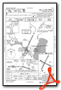
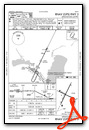
Instrument Approach Procedure (IAP) Charts


Nearby Airports with Instrument Procedures
| ID | Name | Heading / Distance | ||
|---|---|---|---|---|
 |
KOSH | Wittman Regional Airport | 185° | 16.5 |
|
KGRB | Green Bay/Austin Straubel International Airport | 050° | 21.6 |
|
KPCZ | Waupaca Municipal Airport | 281° | 22.0 |
|
KCLI | Clintonville Municipal Airport | 336° | 23.2 |
|
8D1 | New Holstein Municipal Airport | 137° | 25.7 |
|
KFLD | Fond Du Lac County Airport | 177° | 29.2 |
|
KEZS | Shawano Municipal Airport | 356° | 31.8 |
|
Y50 | Wautoma Municipal Airport | 249° | 36.3 |
|
KMTW | Manitowoc County Airport | 101° | 37.0 |
|
KSBM | Sheboygan County Memorial International Airport | 135° | 41.1 |
|
KOCQ | Oconto/J Douglas Bake Municipal Airport | 035° | 45.3 |
|
KSTE | Stevens Point Municipal Airport | 291° | 46.8 |
Fuel Providers

Airport Images
Do you have a recent image of this airport? Upload it here!


