Login
Register


X59
Valkaria Airport
Official FAA Data Effective 2026-02-19 0901Z
Chart Supplement

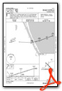
VFR Chart of X59
Sectional Charts at SkyVector.com
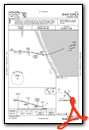
IFR Chart of X59
Enroute Charts at SkyVector.com
Location Information for X59
Coordinates: N27°57.65' / W80°33.50'Located 01 miles W of Valkaria, Florida on 660 acres of land. View all Airports in Florida.
Surveyed Elevation is 25 feet MSL.
Operations Data
|
|
Airport Communications
| AWOS-3PT: | 119.525 |
|---|---|
| ORLANDO APPROACH: | 126.025 281.425 |
| ORLANDO DEPARTURE: | 126.025 281.425 |
| CTAF: | 122.725 |
| UNICOM: | 122.725 |
| ASOS at MLB (9.3 NW): | 132.55 321-951-7575 |
| AWOS-3PT at X26 (9.6 S): | 118.125 772-228-7020 |
| ATIS at MLB (9.7 NW): | 132.55 |
Nearby Navigation Aids
|
| ||||||||||||||||||||||||||||||||||||


Runway 10/28
| Dimensions: | 4000 x 75 feet / 1219 x 23 meters | |
|---|---|---|
| Surface: | Asphalt in Fair Condition | |
| Weight Limits: | 6 /F/B/Y/T, S-12 | |
| Runway 10 | Runway 28 | |
| Coordinates: | N27°57.57' / W80°33.95' | N27°57.57' / W80°33.20' |
| Elevation: | 23.5 | 25.7 |
| Markings: | Basic in fair condition. | Basic in fair condition. |
| Glide Slope Indicator | P4R (3.00° Glide Path Angle) | |
| Obstacles: | 37 ft Trees 735 ft from runway, 90 ft right of center | 20 ft Trees 430 ft from runway, 120 ft left of center |
Runway 14/32
| Dimensions: | 4000 x 75 feet / 1219 x 23 meters | |
|---|---|---|
| Surface: | Asphalt in Good Condition | |
| Weight Limits: | 8 /F/A/Y/T, S-12 | |
| Edge Lighting: | Medium Intensity | |
| Runway 14 | Runway 32 | |
| Coordinates: | N27°57.97' / W80°33.67' | N27°57.49' / W80°33.17' |
| Elevation: | 24.6 | 24.2 |
| Traffic Pattern: | Left | Left |
| Markings: | Non-Precision Instrument in fair condition. | Non-Precision Instrument in fair condition. |
| Glide Slope Indicator | P4R (3.00° Glide Path Angle) | P4L (3.00° Glide Path Angle) |
| Obstacles: | 23 ft Trees 485 ft from runway, 95 ft left of center | 21 ft Trees 460 ft from runway, 125 ft left of center |
Services Available
| Fuel: | 100LL (blue) |
|---|---|
| Transient Storage: | Tiedowns |
| Airframe Repair: | MAJOR |
| Engine Repair: | MAJOR |
| Bottled Oxygen: | NONE |
| Bulk Oxygen: | NONE |
| Other Services: | CROP DUSTING SERVICES,AVIONICS,PILOT INSTRUCTION,AIRCRAFT RENTAL,GLIDER TOWING SERVICES |
Ownership Information
| Ownership: | Publicly owned | |
|---|---|---|
| Owner: | BREVARD COUNTY | |
| 2725 JUDGE FRAN JAMIESON WAY, BUILDING C SUITE 301 | ||
| VIERA, FL 32940 | ||
| 321-633-2001 | ||
| Manager: | PHILLIP HIED | |
| 1 PILOT'S PLACE | ||
| VALKARIA, FL 32950 | ||
| 321-952-4590 | ||
Other Remarks
- USE CTN EXTSV PWRD PARAGLIDER OPS.
- FOR CD OR TO CNL IFR CTC ORLANDO APCH AT 407-852-7500.
- TSNT GATE CODE 1467.
- FM TOUCH & GO OPNS PROHIBITED IF THERE ARE 3 OR MORE ACFT IN THE TFC PAT.
- TRANSIENT AIRCRAFT PLEASE PARK ON APRON BETWEEN AIRPORT BEACON AND TERMINAL.
- PPR FOR ACFT EQUIPPED WITH WEATHER MODIFICATION OR GEOENGINEERING EQPT CALL 321-952-4590 MON-FRI 0800-1700 EXCLD HOLS.
- APLG NOT OPR DURG DALGT HOURS. SS-SR, ACTVT MIRL 14/32- CTAF.
- AUTOMATED UNICOM.
Weather Minimums

Instrument Approach Procedure (IAP) Charts
Nearby Airports with Instrument Procedures
| ID | Name | Heading / Distance | ||
|---|---|---|---|---|
 |
X26 | Sebastian Municipal Airport | 159° | 9.4 |
|
KMLB | Melbourne Orlando International Airport | 331° | 9.7 |
|
KCOF | Patrick Space Force Base Airport | 350° | 16.6 |
|
KVRB | Vero Beach Regional Airport | 157° | 19.7 |
|
KCOI | Merritt Island Airport | 343° | 23.8 |
|
KFPR | Treasure Coast International Airport | 160° | 29.4 |
|
KXMR | Cape Canaveral Space Force Station Skid Strip Airport | 359° | 30.3 |
|
KTIX | Space Coast Regional Airport | 338° | 35.5 |
|
KTTS | Space Florida Launch and Landing Facility Airport | 349° | 39.8 |
|
X21 | Arthur Dunn Air Park Airport | 339° | 42.2 |
|
KOBE | Okeechobee County Airport | 200° | 44.4 |
|
KMCO | Orlando International Airport | 305° | 48.7 |
Airport Images

By: Big Orange Bird


