Login
Register


COI
Merritt Island Airport
Official FAA Data Effective 2026-02-19 0901Z
Chart Supplement

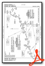
VFR Chart of KCOI
Sectional Charts at SkyVector.com
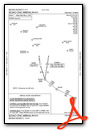
IFR Chart of KCOI
Enroute Charts at SkyVector.com
Location Information for KCOI
Coordinates: N28°20.50' / W80°41.13'Located 00 miles S of Merritt Island, Florida on 140 acres of land. View all Airports in Florida.
Surveyed Elevation is 5 feet MSL.
Operations Data
|
|
Airport Communications
| AWOS-3PT: | 119.025 Tel. 321-986-8864 |
|---|---|
| ORLANDO APPROACH: | 134.95 281.425 |
| ORLANDO DEPARTURE: | 134.95 281.425 |
| BITHO STAR: | 128.375 338.2 |
| UNICOM: | 122.975 |
| CTAF: | 122.975 |
| MINEE STAR: | 134.05 339.8 |
| ATIS at COF (7.5 SE): | 119.175 |
| ASOS at XMR (9.8 NE): | 119.325 |
| AWOS-3PT at TIX (11.6 NW): | 120.625 321-567-6090 |
Nearby Navigation Aids
|
| ||||||||||||||||||||||||||||||||||||


Runway 11/29
| Dimensions: | 3601 x 75 feet / 1098 x 23 meters | |
|---|---|---|
| Surface: | Asphalt in Fair Condition | |
| Weight Limits: | 23 /F/A/X/T, S-22 | |
| Edge Lighting: | Medium Intensity | |
| Runway 11 | Runway 29 | |
| Coordinates: | N28°20.59' / W80°41.45' | N28°20.40' / W80°40.81' |
| Elevation: | 5.8 | 2.6 |
| Traffic Pattern: | Left | Left |
| Runway Heading: | 109° True | 289° True |
| Markings: | Non-Precision Instrument in poor condition. | Non-Precision Instrument in poor condition. |
| Glide Slope Indicator | P2L (3.00° Glide Path Angle) | P2L (3.00° Glide Path Angle) |
| Obstacles: | 20 ft Building 122 ft from runway, 250 ft left of center APCH SLOPE 20:1 TO THE DSPLCD THLD. UNLGT OBS IN APCH; 20 FT BLDG 122 FT FM RWY 250 FT L. |
25 ft Boat 700 ft from runway, 250 ft right of center |
Services Available
| Fuel: | 100LL (blue), Jet-A |
|---|---|
| Transient Storage: | Tiedowns |
| Airframe Repair: | MAJOR |
| Engine Repair: | MAJOR |
| Bottled Oxygen: | NONE |
| Bulk Oxygen: | NONE |
| Other Services: | AVIONICS,PILOT INSTRUCTION,AIRCRAFT RENTAL |
Ownership Information
| Ownership: | Publicly owned | |
|---|---|---|
| Owner: | TITUSVILLE-COCOA AIRPORT DISTRICT | CTC PERSON: KEVIN DAUGHERTY, AAE |
| 355 GOLDEN KNIGHTS BLVD | ||
| TITUSVILLE, FL 32780 | ||
| 321-267-8780 | ||
| Manager: | KEVIN DAUGHERTY | |
| 355 GOLDEN KNIGHTS BLVD | ||
| TITUSVILLE, FL 32780 | ||
| 321-267-8780 | 321-453-2222. | |
Other Remarks
- BANNER TOWING.
- 24 HR HELI OPS SW RAMP.
- PATRICK AFB (KCOF) CLASS D AIRSPACE IN CLOSE PROXIMITY; KCOF CROSSING RWY 11/29 HAS SAME ORIENTATION AS MERRITT ISLAND ARPT.
- FOR CD OR TO CNL IFR CTC ORLANDO APCH AT 407-852-7500.
- NOISE SENSITIVE ARPT. VOLUNTARY NOISE ABATEMENT PROC IN EFCT. CLIMB OUT AT BEST ANGLE (VX), TURN CROSSWIND AT 700 FT (MID-RIVER, IF POSS) & MERGE WITH DOWNWIND TFC AT 1000 FT PAT ALT. NO TOUCH-AND-GO OPS BTN 8 PM AND 8 AM. NO REPETITIVE FLT OPS AT THE ARPT BTN 8 PM AND 7 AM. NO REPETITIVE FLT T OPS ON SUN AND NTL HOLS. IN LIEU OF TOUCH-AND-GO OPS PERFORM FULL STOP, TAXI-BACK OPS. AVOID FLYING AT LOW ALTS OVR NOISE SENSITIVE AREAS (NEWFOUND HARBOR DR).
- RWY 11 MARKINGS FADED W/ NO BLACK OUTLINE.
- RWY 29 MARKINGS FADED W/ NO BLACK OUTLINE.
- ACTVT MIRL RWY 11/29 - CTAF.
- ACTVT ROTG BCN - CTAF.
Weather Minimums
Standard Terminal Arrival (STAR) Charts


Instrument Approach Procedure (IAP) Charts

Nearby Airports with Instrument Procedures
| ID | Name | Heading / Distance | ||
|---|---|---|---|---|
 |
KCOF | Patrick Space Force Base Airport | 147° | 7.5 |
|
KXMR | Cape Canaveral Space Force Station Skid Strip Airport | 039° | 9.8 |
|
KTIX | Space Coast Regional Airport | 329° | 12.0 |
|
KMLB | Melbourne Orlando International Airport | 171° | 14.5 |
|
KTTS | Space Florida Launch and Landing Facility Airport | 358° | 16.4 |
|
X21 | Arthur Dunn Air Park Airport | 334° | 18.6 |
|
X59 | Valkaria Airport | 163° | 23.8 |
|
X26 | Sebastian Municipal Airport | 162° | 33.2 |
|
KMCO | Orlando International Airport | 279° | 33.4 |
|
KORL | Orlando Exec Airport | 289° | 36.4 |
|
KSFB | Orlando Sanford International Airport | 312° | 39.0 |
|
KISM | Kissimmee Gateway Airport | 265° | 39.9 |


Comments
Self serve pumps are down
Self serve pump will be down until June 21. See NOTAMS.
Self Service Fuel pumps Down
13 OCT 2022 Self service fuel is not working. Unknown when repairs will take place. Fuel is available by fuel truck during business hours. Better to call and check status before landing. No NOTAM has been issued. Self service pumps back up on21 OCT 2022.
Strongly recommend not to
Strongly recommend not to park at KCOI's Space Coast Aviation / 2Fly flight school. Landing fee is $40.00 (unless you refuel) for absolutely no services. Not even indications on where to park. We just parked where we thought was best. The airport is extremely busy with students flying and always a mess. DO NOT RECOMMEND.
Tiziano
FUEL
Fuel is back in service. At the Fuel Farm and/or with the Fuel Track
MIRKO GIOMBI
Pages