Login
Register


TOA
Zamperini Field Airport
Official FAA Data Effective 2026-02-19 0901Z
From the Flight Deck
Chart Supplement

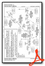
KTOA Airport Diagram

VFR Chart of KTOA
Sectional Charts at SkyVector.com
IFR Chart of KTOA
Enroute Charts at SkyVector.com
Location Information for KTOA
Coordinates: N33°48.20' / W118°20.38'Located 03 miles SW of Torrance, California on 506 acres of land. View all Airports in California.
Surveyed Elevation is 103 feet MSL.
Operations Data
|
|
Airport Communications
| ATIS: | 125.6 (310-534-2847) |
|---|---|
| TORRANCE TOWER: | 124.0 ;SOUTH 133.075 ;NORTH 257.8 |
| TORRANCE GROUND: | 120.9 |
| SOCAL APPROACH: | 124.3 ;RWY 11L, 11R 127.2 ;RWY 29L/R 269.6 ;RWY 29L/R 363.2 ;RWY 11L/R |
| SOCAL DEPARTURE: | 124.3 ;RWY 29L, 29R 127.2 ;RWY 11L/R 269.6 ;RWY 11L/R 363.2 ;RWY 29L/R |
| IC: | 257.8 |
| UNICOM: | 122.950 |
| CTAF: | 124.000 |
| HAWWC DP: | 127.2 ;RWY 11L/R 134.9 ;RWY 29L/R 269.6 ;RWY 11L/R 360.7 ;RWY 29L/R |
| AWOS-3PT at CPM (7.0 NE): | 127.150 310-631-3022 |
| ATIS at HHR (7.2 N): | 118.4 |
| ASOS at HHR (7.2 N): | 310-973-8930 |
- TWR SECTORIZATION IS BASED ON CENTER OF ARPT PARALLEL TO RY 11/29 CNTRLN.
Nearby Navigation Aids
|
| ||||||||||||||||||||||||||||||||||||||||||


Runway 11L/29R
| Dimensions: | 5001 x 150 feet / 1524 x 46 meters | |
|---|---|---|
| Surface: | Asphalt-Concrete in Fair Condition | |
| Weight Limits: | S-30, D-50, ST-90 | |
| Edge Lighting: | Medium Intensity | |
| Runway 11L | Runway 29R | |
| Coordinates: | N33°48.48' / W118°20.74' | N33°47.97' / W118°19.97' |
| Elevation: | 83.0 | 96.8 |
| Traffic Pattern: | Left | Right |
| Runway Heading: | 128° True | 308° True |
| Displaced Threshold: | 541 Feet | 540 Feet |
| Markings: | Precision Instrument in fair condition. | Precision Instrument in fair condition. |
| Glide Slope Indicator | V2L (3.50° Glide Path Angle) | V4L (4.00° Glide Path Angle) |
| Approach Lights: | MALSR 1,400 Foot Medium-intensity Approach Lighting System with runway alignment indicator lights. | |
| Obstacles: | 35 ft Trees 690 ft from runway RWY 11L APCH RATIO TO DSPLCD THR 35:1; |
22 ft Building 475 ft from runway, 530 ft left of center APCH RATIO 46:1 TO DSPLCD THLD. +9 FT MALSR BLDG 190 FT FROM E OR 440 FT RIGHT. |
Runway 11R/29L
| Dimensions: | 3000 x 75 feet / 914 x 23 meters | |
|---|---|---|
| Surface: | Asphalt-Concrete in Fair Condition | |
| Weight Limits: | S-28 | |
| Edge Lighting: | Medium Intensity | |
| Runway 11R | Runway 29L | |
| Coordinates: | N33°48.32' / W118°20.65' | N33°48.01' / W118°20.18' |
| Elevation: | 96.3 | 103.2 |
| Traffic Pattern: | Right | Left |
| Runway Heading: | 128° True | 308° True |
| Markings: | Basic in fair condition. | Basic in fair condition. |
| Glide Slope Indicator | V2L (4.00° Glide Path Angle) UNUSBL BYD 2 DEG RIGHT & 9 DEG LEFT OF RWY CNTRLN. | |
| REIL: | Yes | |
| Obstacles: | 26 ft Building 1400 ft from runway, 100 ft left of center | |
Helipad H1
| Dimensions: | 110 x 110 feet / 34 x 34 meters | |
|---|---|---|
| Surface: | Asphalt in Good Condition FATO AND TLOF PAVED. | |
| Edge Lighting: | Perimeter YELLOW PERIMETER LGTS. | |
| Coordinates: | N33°48.56' / W118°20.74' | N0°0.00' / E0°0.00' |
| Elevation: | 79.0 | |
Services Available
| Fuel: | 100LL (blue) |
|---|---|
| Transient Storage: | Tiedowns |
| Airframe Repair: | MAJOR |
| Engine Repair: | MAJOR |
| Bottled Oxygen: | HIGH/LOW |
| Bulk Oxygen: | HIGH/LOW |
| Other Services: | AVIONICS,CHARTER SERVICE,PILOT INSTRUCTION,AIRCRAFT RENTAL,AIRCRAFT SALES |
Ownership Information
| Ownership: | Publicly owned | |
|---|---|---|
| Owner: | CITY OF TORRANCE | |
| 3031 TORRANCE BLVD | ||
| TORRANCE, CA 90503 | ||
| 310-784-7900 | ||
| Manager: | RAFAEL HERRERA | |
| CITY OF TORRANCE, 3301 AIRPORT DRIVE | ||
| TORRANCE, CA 90505 | ||
| 310-784-7914 | ||
Other Remarks
- NUMEROUS FLOCKS OF BIRDS ON AND INVOF ARPT.
- FOR CD WHEN ATCT CLSD CTC SOCAL APCH AT 800-448-3724.
- LNDG FAC IS FQTLY USED FOR MED AMBULANCE PURPOSES.
- TSNT PRKG LCTD AT THE BASE OF THE ATCT. GREEN BOX WHITE T FOR SMALL ACFT; BLUE BOX WHITE T FOR JETS.
- NO TGL OR STOP & GO OPS PMTD. NO LOW APCH OR FULL STOP TAXI-BACK PMTD BTN 1800-1000 MON-FRI. NO LOW APCH OR FULL STOP TAXI-BACK PMTD SAT, SUN BTN FRI 1800 & MON 1000, OR HOLS. ARPT CLSD TO DEP 2200-0700 WKDAYS & 2200-0800 WKENDS & HOLS.
- NO MULTI-ENGINE SIMULATED ENGINE-OUT PROCS AUTH IN TFC PAT. RY 11R/29L CLSD 2000-0700.
- NOISE SENSITIVE AREA ALL QUADS. FOR NOISE ABATEMENT PROCS INFO CTC ARPT NOISE ABATEMENT (310) 784-7950. CERTAIN TBJT ACFT PERMLY EXCLDD.
- AT TWYS HOTEL & CHARLIE OBS TWY HOLD LINES. ALL ACFT MUST HOLD BTN THE SET OF HOLD BARS FOR THE APCH ZONE FOR RWY 11R/29L.
- BE ALERT TO PSNL & EQPT OPRG NEAR ALL RWYS AND TWYS.
- 0LL FUEL AVBL 0700-2000.
- WHEN ATCT CLSD ACTVT MALSR RY 29R - CTAF; MIRL RY 11L/29R SS-SR; MIRL RY 11R/29L 0600-2000; ACTVT HELIPAD PERIMETER LGTS - 24 HRS - CTAF. VASI RWY 29L OPER CONSLY.
Weather Minimums

Standard Terminal Arrival (STAR) Charts
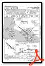
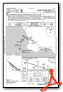
Instrument Approach Procedure (IAP) Charts


Departure Procedure (DP) Charts
Nearby Airports with Instrument Procedures
| ID | Name | Heading / Distance | ||
|---|---|---|---|---|
 |
KHHR | Jack Northrop Field/Hawthorne Municipal Airport | 001° | 7.2 |
|
KLAX | Los Angeles International Airport | 337° | 9.0 |
|
KLGB | Long Beach (Daugherty Field) Airport | 084° | 9.4 |
|
KSMO | Santa Monica Municipal Airport | 336° | 13.9 |
|
KSLI | Los Alamitos AAF Airport | 093° | 14.4 |
|
KFUL | Fullerton Municipal Airport | 077° | 18.4 |
|
KEMT | San Gabriel Valley Airport | 041° | 22.8 |
|
KBUR | Bob Hope Airport | 357° | 23.8 |
|
KAVX | Catalina Airport | 189° | 24.2 |
|
KSNA | John Wayne/Orange County Airport | 107° | 24.8 |
|
KVNY | Van Nuys Airport | 342° | 25.5 |
|
KWHP | Whiteman Airport | 352° | 27.6 |
Airport Images

By: www.focalflight.com

By: david@astonmark...
- 1 of 2
- next ›


Comments
Torrrance City website for Torrance Airport
https://www.torranceca.gov/government/city-departments/general-services/torrance-airport
Gary
Landing fees now being charged...
When you land at KTOA they capture your tail number. There is a monthly bill from vector, the company managing the program. $3/1000lbs MGTW (rounded down) so a typical 172 is $6 per landing. Not per day, per flight. So pattern work will get costly. The intent is to reduce airport operations. They also have city code prohibiting touch and go, stop and go, low approach, full stop taxi back and southern turns early in the pattern. Be careful not everything is published, call someone and if they answer ask about current restrictions. If you land and then depart straight to the cost, you are good, just watch out for the noise sensors. Chart Supplement Remarks (at the time of the comment) are not current to the newly passed code regarding the touch and goes and stuff.
Gary
Pages