Login
Register


GCC
Northeast Wyoming Regional Airport
Official FAA Data Effective 2026-01-22 0901Z
Chart Supplement

KGCC Airport Diagram

VFR Chart of KGCC
Sectional Charts at SkyVector.com
IFR Chart of KGCC
Enroute Charts at SkyVector.com
Location Information for KGCC
Coordinates: N44°20.93' / W105°32.36'Located 04 miles NW of Gillette, Wyoming on 894 acres of land. View all Airports in Wyoming.
Surveyed Elevation is 4365 feet MSL.
TPA: 800 FT AGL LGT ACFT, 1200 FT AGL LRG ACFT.
Operations Data
|
|
Airport Communications
| ASOS: | 124.175 Tel. 307-225-9101 |
|---|---|
| UNICOM: | 122.950 |
| CTAF: | 118.500 |
| AWOS-3PT at W43 (45.7 NE): | 128.775 307-467-5575 |
| ASOS at BYG (50.8 W): | 135.425 307-684-2558 |
| AWOS-3PT at ECS (59.8 SE): | 118.0 307-746-4896 |
- APCH/DEP CTL SVC PRVDD BY DENVER ARTCC (ZDV) ON FREQS 135.6/363.025 (SUNDANCE RCAG).
Nearby Navigation Aids
|
| ||||||||||||||||||||||||||||||||||||||||||


Runway 16/34
| Dimensions: | 7501 x 150 feet / 2286 x 46 meters | |
|---|---|---|
| Surface: | Concrete / Grooved in Good Condition | |
| Weight Limits: | S-70, D-110, ST-160
PCR VALUE: 580/R/D/W/T
| |
| Edge Lighting: | High Intensity | |
| Runway 16 | Runway 34 | |
| Coordinates: | N44°21.42' / W105°32.63' | N44°20.21' / W105°32.33' |
| Elevation: | 4337.0 | 4364.9 |
| Traffic Pattern: | Left | Left |
| Runway Heading: | 170° True | 350° True |
| Declared Distances: | TORA:7500 TODA:7500 ASDA:7500 LDA:7500 | TORA:7500 TODA:7500 ASDA:7500 LDA:7500 |
| Markings: | Precision Instrument in good condition. | Precision Instrument in good condition. |
| Glide Slope Indicator | P4L (3.17° Glide Path Angle) | P4L (3.20° Glide Path Angle) |
| Approach Lights: | MALSR 1,400 Foot Medium-intensity Approach Lighting System with runway alignment indicator lights. | |
| REIL: | Yes | |
| Obstacles: | 56 ft Road 1600 ft from runway +56 FT BLDG 1600 FT FM RWY END 568 FT R. |
312 ft Power Line 9732 ft from runway, 1351 ft right of center |
Runway 03/21
| Dimensions: | 5804 x 75 feet / 1769 x 23 meters | |
|---|---|---|
| Surface: | Concrete / Grooved in Good Condition | |
| Weight Limits: | S-40, D-60
PCR VALUE: 240/R/D/W/T
| |
| Edge Lighting: | Medium Intensity | |
| Runway 03 | Runway 21 | |
| Coordinates: | N44°20.72' / W105°32.62' | N44°21.46' / W105°31.80' |
| Elevation: | 4343.0 | 4317.0 |
| Traffic Pattern: | Left | Left |
| Runway Heading: | 38° True | 218° True |
| Declared Distances: | TORA:5803 TODA:5803 ASDA:5803 LDA:5803 | TORA:5803 TODA:5803 ASDA:5803 LDA:5803 |
| Markings: | Non-Precision Instrument in good condition. | Non-Precision Instrument in good condition. |
| Glide Slope Indicator | P4L (4.00° Glide Path Angle) | P4L (4.00° Glide Path Angle) |
| REIL: | Yes | Yes |
Services Available
| Fuel: | 100LL (blue), Jet-A, Jet A+ |
|---|---|
| Transient Storage: | Hangars,Tiedowns |
| Airframe Repair: | NONE |
| Engine Repair: | NONE |
| Bottled Oxygen: | NONE |
| Bulk Oxygen: | HIGH/LOW |
| Other Services: | AIR FREIGHT SERVICES,CARGO HANDLING SERVICES,CHARTER SERVICE,PILOT INSTRUCTION,AIRCRAFT RENTAL,AIRCRAFT SALES,ANNUAL SURVEYING |
Ownership Information
| Ownership: | Publicly owned | |
|---|---|---|
| Owner: | CAMPBELL CO | |
| 307 TERMINAL LOOP, SUITE 108 | ||
| GILLETTE, WY 82716 | ||
| 307-686-1042 | ||
| Manager: | TODD CHATFIELD | |
| 307 TERMINAL LOOP, SUITE 108 | ||
| GILLETTE, WY 82716 | ||
| 307-686-1042 | 307-686-1042 | |
Other Remarks
- OPN ON UNPAVED SFCS PROHIBITED.
- AFT HRS OPS CTC - 307-257-3137
- MINING/BLASTING OPNS 1/2 MILE N OF AOA DURG DALGT HRS.
- BIRDS INVOF ARPT.
- CONDS UNMON.
- 0LL FUEL AVBL H24 VIA CREDIT CARD.
- ACTVT MALSR RWY 34; REILS RWYS 03, 16, &21; HIRL RWY 16/34; MIRL RWY 03/21 - CTAF. SEQUENCE FLASHERS RWY 34 AVBL ON HIGH SETTING ONLY. PAPI RWYS 03, 16, 21, 34 OPR CONSLY.
- TPA: 800 FT AGL LGT ACFT, 1200 FT AGL LRG ACFT.
Weather Minimums

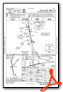
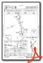
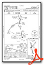
Instrument Approach Procedure (IAP) Charts

Nearby Airports with Instrument Procedures
| ID | Name | Heading / Distance | ||
|---|---|---|---|---|
 |
W43 | Hulett Municipal Airport | 065° | 45.8 |
|
KBYG | Johnson County Airport | 272° | 50.9 |
|
KECS | Mondell Field Airport | 117° | 59.8 |
|
KSHR | Sheridan County Airport | 292° | 66.8 |
|
KEFC | Belle Fourche Municipal Airport | 071° | 75.6 |
|
KSPF | Black Hills-Clyde Ice Field Airport | 083° | 75.8 |
|
49B | Sturgis Municipal Airport | 086° | 93.1 |
|
KDGW | Converse County Airport | 175° | 93.3 |
|
KCPR | Casper/Natrona County International Airport | 205° | 95.5 |
|
97M | Ekalaka Airport | 024° | 101.1 |
|
M46 | Colstrip Airport | 331° | 103.0 |
|
KRCA | Ellsworth AFB Airport | 095° | 105.8 |
Airport Images
Do you have a recent image of this airport? Upload it here!


