Login
Register


XVG
Longville Municipal Airport
Official FAA Data Effective 2026-02-19 0901Z
Chart Supplement

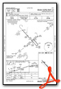
VFR Chart of KXVG
Sectional Charts at SkyVector.com
IFR Chart of KXVG
Enroute Charts at SkyVector.com
Location Information for KXVG
Coordinates: N46°59.39' / W94°12.22'Located 01 miles NE of Longville, Minnesota on 55 acres of land. View all Airports in Minnesota.
Surveyed Elevation is 1336 feet MSL.
Operations Data
|
|
Airport Communications
| AWOS-3: | 118.275 Tel. 218-363-3347 |
|---|---|
| CTAF: | 122.900 |
| AWOS-3PT at PWC (17.5 SW): | 118.525 218-587-3420 |
| AWOS-3PT at Y49 (20.7 NW): | 119.0 218-547-2451 |
| AWOS-3PT at GPZ (31.2 NE): | 118.425 218-326-8337 |
- APCH/DEP SVC PRVDD BY MINNEAPOLIS ARTCC ON FREQS 118.05/239.0 (BRAINERD RCAG).
Nearby Navigation Aids
|
| ||||||||||||||||||||||||||||||||||||||||||||||||||||||||||||


Runway 13/31
| Dimensions: | 3549 x 75 feet / 1082 x 23 meters | |
|---|---|---|
| Surface: | Asphalt in Good Condition | |
| Weight Limits: | S-12, D-14 | |
| Edge Lighting: | Medium Intensity | |
| Runway 13 | Runway 31 | |
| Coordinates: | N46°59.61' / W94°12.50' | N46°59.18' / W94°11.93' |
| Elevation: | 1334.6 | 1330.8 |
| Traffic Pattern: | Left | Left |
| Runway Heading: | 138° True | 318° True |
| Displaced Threshold: | 440 Feet | |
| Declared Distances: | TORA:3549 TODA:3549 ASDA:3549 LDA:3109 | TORA:3549 TODA:3549 ASDA:3549 LDA:3549 |
| Markings: | Non-Precision Instrument in good condition. | Non-Precision Instrument in good condition. |
| Glide Slope Indicator | P4L (4.00° Glide Path Angle) | P4L (3.00° Glide Path Angle) |
| Obstacles: | 20 ft Road 334 ft from runway, 250 ft right of center | |
Services Available
| Fuel: | 100LL (blue) |
|---|---|
| Transient Storage: | Tiedowns |
| Airframe Repair: | NOT AVAILABLE |
| Engine Repair: | NOT AVAILABLE |
| Bottled Oxygen: | NOT AVAILABLE |
| Bulk Oxygen: | NOT AVAILABLE |
| Other Services: | AIRCRAFT SALES |
Ownership Information
| Ownership: | Publicly owned | |
|---|---|---|
| Owner: | CITY OF LONGVILLE | |
| PO BOX 217 | ||
| LONGVILLE, MN 56655-0217 | ||
| 218-363-2022 | ||
| Manager: | CHRISTINA HERHEIM | |
| PO BOX 217 | ||
| LONGVILLE, MN 56655-0217 | ||
| 218-363-2022 | ||
Other Remarks
- DEER & BIRDS ON & INVOF ARPT.
- GCO AVBL ON FREQ 121.725 THRU MINNEAPOLIS ARTCC & PRINCETON FSS.
- FOR CD IF UNA VIA GCO CTC MINNEAPOLIS ARTCC AT 651-463-5588.
- 0LL FUEL AVBL H24 SELF SVC VIA CREDIT CARD.
- ACTVT PAPI RWY 13 & 31; MIRL RWY 13/31 - CTAF.
Weather Minimums


Instrument Approach Procedure (IAP) Charts

Nearby Airports with Instrument Procedures
| ID | Name | Heading / Distance | ||
|---|---|---|---|---|
 |
KPWC | Pine River Regional Airport | 204° | 17.5 |
|
Y49 | Walker Municipal Airport | 299° | 20.8 |
|
KGPZ | Grand Rapids/Itasca County-Gordon Newstrom Field Airport | 064° | 31.3 |
|
KAIT | Aitkin Municipal/Steve Kurtz Field Airport | 140° | 34.3 |
|
KBRD | Brainerd Lakes Regional Airport | 175° | 35.3 |
|
KPKD | Park Rapids Municipal/Konshok Field Airport | 261° | 36.1 |
|
KHZX | Isedor Iverson Airport | 120° | 43.1 |
|
KBJI | Bemidji Regional Airport | 316° | 43.2 |
|
KSAZ | Staples Municipal Airport | 214° | 44.2 |
|
KADC | Wadena Municipal Airport | 232° | 52.7 |
|
KFOZ | Bigfork Municipal Airport | 025° | 52.7 |
|
KRYM | Ray S Miller AAF Airport | 186° | 54.4 |
Airport Images
Do you have a recent image of this airport? Upload it here!


