Login
Register
BRD
Brainerd Lakes Regional Airport
Official FAA Data Effective 2026-01-22 0901Z
VFR Chart of KBRD
Sectional Charts at SkyVector.com
IFR Chart of KBRD
Enroute Charts at SkyVector.com
Location Information for KBRD
Coordinates: N46°24.25' / W94°8.03'Located 03 miles NE of Brainerd, Minnesota on 2597 acres of land. View all Airports in Minnesota.
Surveyed Elevation is 1232 feet MSL.
Operations Data
|
|
Airport Communications
| ASOS: | 126.775 Tel. 218-828-3314 |
|---|---|
| UNICOM: | 122.700 |
| CTAF: | 122.700 |
| AWOS-3 at AIT (20.8 NE): | 118.675 218-927-2101 |
| AWOS-3 at RYM (21.1 SW): | 121.575 |
| AWOS-3PT at PWC (21.9 NW): | 118.525 218-587-3420 |
- APCH/DEP SVC PRVDD BY MINNEAPOLIS ARTCC ON FREQS 118.05/239.0 (BRAINERD RCAG).
Nearby Navigation Aids
|
| ||||||||||||||||||||||||||||||||||||||||||||||||||||||||||||
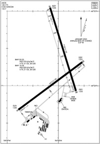
Runway 16/34
| Dimensions: | 7100 x 150 feet / 2164 x 46 meters | |
|---|---|---|
| Surface: | Concrete / Grooved in Excellent Condition | |
| Weight Limits: | S-75, D-125, ST-220
PCR VALUE: 320/R/A/W/T
| |
| Edge Lighting: | High Intensity | |
| Runway 16 | Runway 34 | |
| Coordinates: | N46°25.05' / W94°8.16' | N46°23.93' / W94°7.66' |
| Elevation: | 1226.2 | 1232.2 |
| Runway Heading: | 163° True | 343° True |
| Markings: | Precision Instrument in good condition. | Precision Instrument in good condition. |
| Glide Slope Indicator | P4L (3.00° Glide Path Angle) | P4R (3.00° Glide Path Angle) |
| Approach Lights: | MALSR 1,400 Foot Medium-intensity Approach Lighting System with runway alignment indicator lights. | |
| REIL: | Yes | |
Runway 05/23
| Dimensions: | 6512 x 150 feet / 1985 x 46 meters | |
|---|---|---|
| Surface: | Concrete / Grooved in Good Condition | |
| Weight Limits: | S-75, D-125, ST-220
PCR VALUE: 170/R/A/W/T
| |
| Edge Lighting: | High Intensity | |
| Runway 05 | Runway 23 | |
| Coordinates: | N46°23.68' / W94°8.78' | N46°24.31' / W94°7.53' |
| Elevation: | 1220.3 | 1222.6 |
| Runway Heading: | 54° True | 234° True |
| Markings: | Precision Instrument in good condition. | Precision Instrument in good condition. |
| Glide Slope Indicator | V4L (3.00° Glide Path Angle) | P4L (3.00° Glide Path Angle) PAPI UNUSBL BYD 9 DEG RIGHT OF CRS. |
| Approach Lights: | MALSR 1,400 Foot Medium-intensity Approach Lighting System with runway alignment indicator lights. | |
| REIL: | Yes | |
| Obstacles: | 68 ft Trees 2803 ft from runway, 800 ft left of center | |
Helipad H1
| Dimensions: | 60 x 60 feet / 18 x 18 meters | |
|---|---|---|
| Surface: | Concrete / Grooved in Good Condition | |
| Edge Lighting: | Perimeter | |
| Coordinates: | N46°23.35' / W94°8.33' | N0°0.00' / E0°0.00' |
| Elevation: | 1226.0 | |
| Markings: | Basic in good condition. | |
Services Available
| Fuel: | 100LL (blue), Jet-A |
|---|---|
| Transient Storage: | Hangars,Tiedowns |
| Airframe Repair: | MAJOR |
| Engine Repair: | MAJOR |
| Bottled Oxygen: | HIGH |
| Bulk Oxygen: | HIGH |
| Other Services: | AVIONICS,CHARTER SERVICE,PILOT INSTRUCTION,AIRCRAFT RENTAL,AIRCRAFT SALES,ANNUAL SURVEYING |
Ownership Information
| Ownership: | Publicly owned | |
|---|---|---|
| Owner: | BRAINERD/CROW WING CNTY | |
| 16384 AIRPORT RD, SUITE 5 | ||
| BRAINERD, MN 56401 | ||
| 218-825-2166 | ||
| Manager: | NEIL PLANZER | |
| BRAINERD LAKES REGIONAL ARPT, 16384 AIRPORT RD SUITE 5 | SWRIGHT@BRAINERDAIRPORT.COM. | |
| BRAINERD, MN 56401 | ||
| 218-825-2166 | ||
Other Remarks
- DEER AND GULLS ON & INVOF ARPT.
- FOR ATNDC OTHER HRS, SEE FONE LISTING IN PILOT LOUNGE, 218-829-3398.
- PPR FOR UNSKED ACR OPNS WITH MORE THAN 30 PSGR SEATS CALL AMGR 218-825-2166 BTN 0800-1700. ACR OPNS INVOLVING ACFT WITH MORE THAN 30 PSGRS ARE NOT AUZD IN EXCESS OF 15 MINS BEFORE OR AFTER SKEDD ARR/DEP TIMES WITHOUT PRIOR COORDINATION WITH AMGR AND CFMN THAT ARFF IS AVBL PRIOR TO LNDG OR TKOF.
- FOR CD IF UNA TO CTC ON FSS FREQ, CTC MINNEAPOLIS ARTCC AT 651-463-5588.
- CALM WIND RWY.
- HIRL RWY 05/23 & HIRL RWY 16/34 PRESET ON LOW INTST; TO INCR INTST & ACTVT REIL RWY 05 & 16 AND MALSR RWY 23 & 34 - CTAF.
Weather Minimums
Instrument Approach Procedure (IAP) Charts
Nearby Airports with Instrument Procedures
| ID | Name | Heading / Distance | ||
|---|---|---|---|---|
 |
KAIT | Aitkin Municipal/Steve Kurtz Field Airport | 065° | 20.8 |
 |
KRYM | Ray S Miller AAF Airport | 206° | 21.1 |
 |
KPWC | Pine River Regional Airport | 332° | 21.8 |
 |
KSAZ | Staples Municipal Airport | 267° | 28.0 |
 |
KLXL | Little Falls/Morrison County-Lindbergh Field Airport | 198° | 28.7 |
 |
KXVG | Longville Municipal Airport | 355° | 35.3 |
 |
KHZX | Isedor Iverson Airport | 069° | 36.5 |
 |
14Y | Todd Field Airport | 225° | 43.3 |
 |
KADC | Wadena Municipal Airport | 273° | 44.8 |
 |
KJMR | Mora Municipal Airport | 130° | 47.3 |
 |
KPKD | Park Rapids Municipal/Konshok Field Airport | 307° | 49.0 |
 |
Y49 | Walker Municipal Airport | 335° | 50.0 |


