Login
Register


Y19
Mandan Regional/Lawler Field Airport
Official FAA Data Effective 2025-11-27 0901Z
Chart Supplement

VFR Chart of Y19
Sectional Charts at SkyVector.com
IFR Chart of Y19
Enroute Charts at SkyVector.com
Location Information for Y19
Coordinates: N46°46.08' / W100°53.66'Located 04 miles S of Mandan, North Dakota on 316 acres of land. View all Airports in North Dakota.
Surveyed Elevation is 1944 feet MSL.
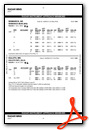
Operations Data
|
|
Airport Communications
| AWOS-3: | 118.225 Tel. 701-663-0271 |
|---|---|
| BISMARCK APPROACH: | 126.3 298.9 |
| BISMARCK DEPARTURE: | 126.3 298.9 |
| UNICOM: | 122.800 |
| CTAF: | 122.800 |
| ASOS at BIS (6.1 E): | 701-922-9747 |
| ATIS at BIS (6.1 E): | 119.35 |
| AWOS-3P at D57 (39.9 W): | 118.75 701-348-9581 |
- APCH/DEP SVC PRVDD BY MINNEAPOLIS ARTCC ON FREQS 135.25/256.7 (WOODWORTH RCAG) WHEN BISMARCK APCH CTL CLSD.
Nearby Navigation Aids
|
| ||||||||||||||||||||||||||||||


Runway 13/31
| Dimensions: | 4399 x 75 feet / 1341 x 23 meters | |
|---|---|---|
| Surface: | Concrete in Good Condition | |
| Weight Limits: | S-12 | |
| Edge Lighting: | Medium Intensity | |
| Runway 13 | Runway 31 | |
| Coordinates: | N46°46.42' / W100°53.95' | N46°45.83' / W100°53.35' |
| Elevation: | 1942.0 | 1943.0 |
| Traffic Pattern: | Left | Left |
| Runway Heading: | 145° True | 325° True |
| Markings: | Non-Precision Instrument in good condition. | Non-Precision Instrument in good condition. |
| Glide Slope Indicator | P2L (3.00° Glide Path Angle) | P2L (3.00° Glide Path Angle) |
| REIL: | Yes | Yes |
Runway 04/22
| Dimensions: | 2921 x 140 feet / 890 x 43 meters | |
|---|---|---|
| Surface: | Turf in Good Condition | |
| Edge Lighting: | Medium Intensity | |
| Runway 04 | Runway 22 | |
| Coordinates: | N46°45.87' / W100°53.97' | N46°46.15' / W100°53.40' |
| Elevation: | 1924.2 | 1943.4 |
| Runway Heading: | 55° True | 235° True |
Services Available
| Fuel: | 100LL (blue) |
|---|---|
| Transient Storage: | Hangars,Tiedowns |
| Airframe Repair: | MAJOR |
| Engine Repair: | MAJOR |
| Bottled Oxygen: | NOT AVAILABLE |
| Bulk Oxygen: | NOT AVAILABLE |
| Other Services: | CROP DUSTING SERVICES,CHARTER SERVICE,PILOT INSTRUCTION,AIRCRAFT RENTAL,AIRCRAFT SALES,ANNUAL SURVEYING |
Ownership Information
| Ownership: | Publicly owned | |
|---|---|---|
| Owner: | MANDAN ARPT AUTHORITY | |
| BOX 250 | ||
| MANDAN, ND 58554 | ||
| 701-663-0669 | ||
| Manager: | LINDSAY GERHARDT | AMGR CELL PHONE 701-955-3328. |
| BOX 250 | ||
| MANDAN, ND 58554 | ||
| 701-663-0669 | ||
Other Remarks
- CFM SN REMOVAL AFT MAJOR WINT STORMS WITH AMGR 701-663-0669 OR 701-955-3328.
- +200 FT TWR LCTD 9500 FT NW OF RWY 13/31.
- 120 FT TWR LCTD 5000 FT SW OF RWY 04/22.
- FOR CD CTC BISMARCK APCH AT 701-223-8790.
- 0LL FOR 100LL FUEL 24 HR SELF SVC WITH CREDIT CARD OR CALL AMGR CELL PHONE 701-955-3328.
- MIRL RY 13/31 & RY 04/22 PRESET ON MED TO INCR INTST & ACTVT - CTAF; ACTVT REIL RY 13/31; & PAPI RY 13/31 - CTAF.
Weather Minimums

Instrument Approach Procedure (IAP) Charts

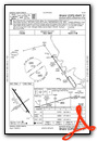

Nearby Airports with Instrument Procedures
| ID | Name | Heading / Distance | ||
|---|---|---|---|---|
 |
KBIS | Bismarck Municipal Airport | 087° | 6.1 |
|
D57 | Glen Ullin Regional Airport | 274° | 40.1 |
|
KHZE | Mercer County Regional Airport | 318° | 42.1 |
|
7L2 | Linton Municipal Airport | 140° | 42.5 |
|
D05 | Garrison Municipal Airport | 337° | 57.7 |
|
3P3 | Mott Municipal Airport | 248° | 64.2 |
|
KLEM | Lemmon Municipal Airport | 225° | 71.7 |
|
5H4 | Harvey Municipal Airport | 032° | 72.9 |
|
KMBG | Mobridge Municipal Airport | 164° | 76.1 |
|
KASY | Ashley Municipal Airport | 124° | 78.1 |
|
KDIK | Dickinson/Theodore Roosevelt Regional Airport | 272° | 78.8 |
|
46D | Carrington Municipal Airport | 059° | 82.4 |
Airport Images

By: Clear Skies Aviation


