Login
Register


BIS
Bismarck Municipal Airport
Official FAA Data Effective 2026-02-19 0901Z
Chart Supplement

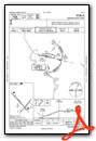
KBIS Airport Diagram

VFR Chart of KBIS
Sectional Charts at SkyVector.com
IFR Chart of KBIS
Enroute Charts at SkyVector.com
Location Information for KBIS
Coordinates: N46°46.36' / W100°44.74'Located 03 miles SE of Bismarck, North Dakota on 2425 acres of land. View all Airports in North Dakota.
Surveyed Elevation is 1661 feet MSL.
Operations Data
|
|
Airport Communications
| ATIS: | 119.35 |
|---|---|
| ASOS: | Tel. 701-922-9747 |
| BISMARCK TOWER: | 118.3 257.8 |
| BISMARCK GROUND: | 121.9 |
| BISMARCK APPROACH: | 126.3 298.9 |
| BISMARCK DEPARTURE: | 126.3 298.9 |
| ARNG OPS: | 134.1 340.1 49.8FM |
| EMERG: | 121.5 243.0 |
| UNICOM: | 122.950 |
| CTAF: | 118.300 |
| AWOS-3 at Y19 (6.1 W): | 118.225 701-663-0271 |
| AWOS-3 at 7L2 (39.1 SE): | 118.175 701-254-4965 |
| AWOS-3PT at HZE (46.0 NW): | 118.675 701-748-2443 |
- APCH/DEP SVC PRVDD BY MINNEAPOLIS ARTCC ON FREQS 135.25/256.7 (WOODWORTH RCAG) WHEN APCH CLSD.
- NATIONAL GUARD OPERATIONS 0630-1500 MON-FRI; EXCEPT HOL; OTHER TIMES PRIOR PERMISSION REQUIRED V362-2160.
Nearby Navigation Aids
|
| ||||||||||||||||||||||||


Runway 13/31
| Dimensions: | 8794 x 150 feet / 2680 x 46 meters | |
|---|---|---|
| Surface: | Asphalt-Concrete / Grooved in Good Condition | |
| Weight Limits: | S-120, D-225, ST-342
PCR VALUE: 750/R/D/W/T
| |
| Edge Lighting: | High Intensity | |
| Runway 13 | Runway 31 | |
| Coordinates: | N46°47.04' / W100°45.71' | N46°45.97' / W100°44.29' |
| Elevation: | 1654.6 | 1645.2 |
| Traffic Pattern: | Left | Left |
| Runway Heading: | 138° True | 318° True |
| Declared Distances: | TORA:8794 TODA:8794 ASDA:8794 LDA:8794 | TORA:8794 TODA:8794 ASDA:8794 LDA:8794 |
| Markings: | Precision Instrument in good condition. | Precision Instrument in good condition. |
| Glide Slope Indicator | P4L (3.00° Glide Path Angle) | P4L (3.00° Glide Path Angle) |
| RVR Equipment | Rollout | Touchdown |
| Approach Lights: | MALS 1,400 Foot Medium-intensity Approach Lighting System. | MALSR 1,400 Foot Medium-intensity Approach Lighting System with runway alignment indicator lights. |
| Obstacles: | 43 ft Pole 1662 ft from runway, 688 ft left of center | |
Runway 03/21
| Dimensions: | 6600 x 100 feet / 2012 x 30 meters | |
|---|---|---|
| Surface: | Asphalt / Grooved in Good Condition | |
| Weight Limits: | S-104, D-140, ST-198
PCR VALUE: 430/F/D/X/T
| |
| Edge Lighting: | High Intensity | |
| Runway 03 | Runway 21 | |
| Coordinates: | N46°45.76' / W100°44.90' | N46°46.60' / W100°43.91' |
| Elevation: | 1660.6 | 1661.3 |
| Runway Heading: | 39° True | 219° True |
| Declared Distances: | TORA:6600 TODA:6600 ASDA:6600 LDA:6600 | TORA:6600 TODA:6600 ASDA:6600 LDA:6600 |
| Markings: | Precision Instrument in good condition. | Precision Instrument in good condition. |
| Glide Slope Indicator | P4L (3.00° Glide Path Angle) | P4L (3.00° Glide Path Angle) |
| REIL: | Yes | Yes |
Services Available
| Fuel: | 100LL (blue), Jet-A |
|---|---|
| Transient Storage: | Hangars,Tiedowns |
| Airframe Repair: | MAJOR |
| Engine Repair: | MAJOR |
| Bottled Oxygen: | NONE |
| Bulk Oxygen: | HIGH/LOW |
| Other Services: | AIR FREIGHT SERVICES,AIR AMBULANCE SERVICES,AVIONICS,CHARTER SERVICE,PILOT INSTRUCTION,AIRCRAFT RENTAL,AIRCRAFT SALES |
Ownership Information
| Ownership: | Publicly owned | |
|---|---|---|
| Owner: | CITY OF BISMARCK | |
| BOX 991 | ||
| BISMARCK, ND 58502 | ||
| 701-355-1808 | ||
| Manager: | GREGORY B HAUG | 24HR CONTACT: OPERATIONS 701-220-9885. |
| BOX 991 | ||
| BISMARCK, ND 58502-0991 | ||
| 701-355-1808 | ||
Other Remarks
- DEER, COYOTES & BIRDS ON & INVOF ARPT.
- RMKS-ARNG: OPR 1200-2130Z++ MON-FRI EXC HOL, PPR 24 PN RQR DSN 373-4071/70, C701-3334071/70. FW PAX TRML LCTD IN 'SE' HGR.
- FOR CD IF UNA TO CTC ON FSS FREQ, CTC MINNEAPOLIS ARTCC AT 651-463-5588.
- RESA NSTD.
- RESA NSTD.
- 0LL FOR FUEL CALL 701-223-4754 OR 701-258-5024.
- WHEN ATCT CLSD HIRL RYS 13/31 & 03/21 PRESET MED INTST; PAPI RYS 13; 31; 03; & 21 ON; ACTVT MALS RY 13 & MALSR RY 31 - CTAF.
Weather Minimums


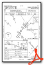
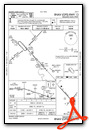
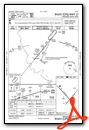
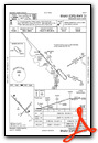
Instrument Approach Procedure (IAP) Charts


Nearby Airports with Instrument Procedures
| ID | Name | Heading / Distance | ||
|---|---|---|---|---|
 |
Y19 | Mandan Regional/Lawler Field Airport | 267° | 6.1 |
|
7L2 | Linton Municipal Airport | 147° | 39.1 |
|
D57 | Glen Ullin Regional Airport | 273° | 46.2 |
|
KHZE | Mercer County Regional Airport | 312° | 46.2 |
|
D05 | Garrison Municipal Airport | 332° | 60.1 |
|
5H4 | Harvey Municipal Airport | 028° | 69.6 |
|
KMBG | Mobridge Municipal Airport | 168° | 75.0 |
|
KLEM | Lemmon Municipal Airport | 228° | 76.3 |
|
46D | Carrington Municipal Airport | 057° | 77.0 |
|
KDIK | Dickinson/Theodore Roosevelt Regional Airport | 271° | 84.9 |
|
KJMS | Jamestown Regional Airport | 082° | 85.7 |
|
51D | Edgeley Municipal Airport | 106° | 87.0 |
Fuel Providers


We proudly offer fuel from:

US Dollar per US Gallon
Price Guaranteed by FBO

Airport Images

By: Executive Air T...

By: Executive Air T...
- 1 of 2
- next ›


