Login
Register


7L2
Linton Municipal Airport
Official FAA Data Effective 2025-12-25 0901Z
Chart Supplement

VFR Chart of 7L2
Sectional Charts at SkyVector.com
IFR Chart of 7L2
Enroute Charts at SkyVector.com
Location Information for 7L2
Coordinates: N46°13.24' / W100°14.74'Located 03 miles SSE of Linton, North Dakota on 190 acres of land. View all Airports in North Dakota.
Surveyed Elevation is 1778 feet MSL.
Operations Data
|
|
Airport Communications
| AWOS-3: | 118.175 Tel. 701-254-4965 |
|---|---|
| CTAF: | 122.900 |
| ASOS at BIS (39.1 NW): | 701-922-9747 |
| ATIS at BIS (39.1 NW): | 119.35 |
| ASOS at MBG (41.0 S): | 121.425 605-206-3018 |
- APCH/DEP SVC PRVDD BY MINNEAPOLIS ARTCC ON FREQS 135.25/256.7 (WOODWORTH RCAG).
Nearby Navigation Aids
|
| ||||||||||||||||||||||||||||||||||||||||||


Runway 09/27
| Dimensions: | 3700 x 60 feet / 1128 x 18 meters | |
|---|---|---|
| Surface: | Asphalt in Good Condition | |
| Weight Limits: | S-12 | |
| Edge Lighting: | Medium Intensity | |
| Runway 09 | Runway 27 | |
| Coordinates: | N46°13.32' / W100°15.16' | N46°13.15' / W100°14.32' |
| Elevation: | 1764.6 | 1778.6 |
| Traffic Pattern: | Left | Left |
| Runway Heading: | 106° True | 286° True |
| Markings: | Non-Precision Instrument in fair condition. | Non-Precision Instrument in fair condition. |
| Glide Slope Indicator | P2L (3.00° Glide Path Angle) | P2L (3.00° Glide Path Angle) |
Services Available
| Fuel: | 100LL (blue), Jet-A |
|---|---|
| Transient Storage: | Hangars,Tiedowns |
| Airframe Repair: | NONE |
| Engine Repair: | NONE |
| Bottled Oxygen: | NONE |
| Bulk Oxygen: | NONE |
| Other Services: | CROP DUSTING SERVICES,PILOT INSTRUCTION |
Ownership Information
| Ownership: | Publicly owned | |
|---|---|---|
| Owner: | LINTON ARPT AUTH | |
| PO BOX 301 | ||
| LINTON, ND 58552 | ||
| 701-321-0173 | ||
| Manager: | TRAVIS DOCKTER | |
| PO BOX 301 | ||
| LINTON, ND 58552 | ||
| 701-321-0173 | ADDNL PHONE 701-254-5449 | |
Other Remarks
- CONFIRM WINTER COND BEFORE USE WITH AMGR 701-321-0173 OR 254-5449.
- DEER AND BIRDS ON & INVOF ARPT.
- FOR CD CTC MINNEAPOLIS ARTCC AT 651-463-5588.
- 0LL SELF SERVICE 24 HOUR CREDIT CARD FUEL SYSTEM AVAILABLE.
- ACTVT MIRL RY 09/27 & PAPI RYS 09 & 27 - CTAF.
Weather Minimums
Instrument Approach Procedure (IAP) Charts
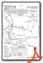

Nearby Airports with Instrument Procedures
| ID | Name | Heading / Distance | ||
|---|---|---|---|---|
 |
KASY | Ashley Municipal Airport | 107° | 39.1 |
|
KBIS | Bismarck Municipal Airport | 328° | 39.1 |
|
KMBG | Mobridge Municipal Airport | 189° | 41.0 |
|
Y19 | Mandan Regional/Lawler Field Airport | 320° | 42.5 |
|
51D | Edgeley Municipal Airport | 082° | 63.3 |
|
4E7 | Ellendale Municipal Airport | 099° | 73.2 |
|
0D8 | Gettysburg Municipal Airport | 170° | 75.1 |
|
D57 | Glen Ullin Regional Airport | 298° | 76.0 |
|
KJMS | Jamestown Regional Airport | 056° | 77.6 |
|
KLEM | Lemmon Municipal Airport | 257° | 79.8 |
|
KHZE | Mercer County Regional Airport | 319° | 84.6 |
|
84D | Cheyenne Eagle Butte Airport | 210° | 85.4 |
Airport Images
Do you have a recent image of this airport? Upload it here!


