Login
Register


LHQ
Fairfield County Airport
Official FAA Data Effective 2025-02-20 0901Z
Chart Supplement

VFR Chart of KLHQ
Sectional Charts at SkyVector.com
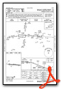
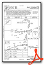
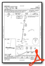
IFR Chart of KLHQ
Enroute Charts at SkyVector.com
Location Information for KLHQ
Coordinates: N39°45.34' / W82°39.43'Located 03 miles NW of Lancaster, Ohio on 130 acres of land. View all Airports in Ohio.
Surveyed Elevation is 868 feet MSL.
Operations Data
|
|
Airport Communications
| ASOS: | 118.375 Tel. 740-681-1097 |
|---|---|
| COLUMBUS APPROACH: | 132.3 ;100-279 134.0 279.6 |
| COLUMBUS DEPARTURE: | 132.3 ;100-279 134.0 279.6 |
| IC: | 134.0 279.6 |
| CLEARANCE DELIVERY: | 121.65 |
| CTAF: | 122.725 |
| UNICOM: | 122.725 |
| CLASS C/S: | 132.3 ;100-279 |
| ATIS at LCK (13.0 W): | 132.75 |
| AWOS-3 at LCK (13.4 W): | 614-492-2441 |
| ASOS at CMH (17.8 NW): | 124.6 614-338-4083 |
Nearby Navigation Aids
|
| ||||||||||||||||||||||||||||||||||||||||||||||||||||||||||||


Runway 10/28
| Dimensions: | 5003 x 75 feet / 1525 x 23 meters | |
|---|---|---|
| Surface: | Asphalt in Good Condition | |
| Weight Limits: | S-25, D-38 | |
| Edge Lighting: | Medium Intensity | |
| Runway 10 | Runway 28 | |
| Coordinates: | N39°45.37' / W82°39.96' | N39°45.31' / W82°38.89' |
| Elevation: | 857.3 | 868.4 |
| Traffic Pattern: | Left | Right |
| Runway Heading: | 94° True | 274° True |
| Markings: | Non-Precision Instrument in good condition. | Non-Precision Instrument in good condition. |
| Glide Slope Indicator | P2L (3.00° Glide Path Angle) | P2L (3.50° Glide Path Angle) |
| REIL: | Yes | Yes |
| Obstacles: | 60 ft Trees 795 ft from runway, 95 ft right of center | 6 ft Berm 260 ft from runway, 250 ft right of center |
Services Available
| Fuel: | 100LL (blue), Jet A+ |
|---|---|
| Transient Storage: | Hangars,Tiedowns PRIOR CDN RQRD. |
| Airframe Repair: | MAJOR |
| Engine Repair: | MAJOR |
| Bottled Oxygen: | NONE |
| Bulk Oxygen: | NONE |
| Other Services: | PILOT INSTRUCTION,AIRCRAFT RENTAL,AIRCRAFT SALES,ANNUAL SURVEYING |
Ownership Information
| Ownership: | Publicly owned | |
|---|---|---|
| Owner: | FAIRFIELD CO COMMISSIONERS | |
| 210 E MAIN ST RM 301 | ||
| LANCASTER, OH 43130-3854 | ||
| 740-654-7001 | ||
| Manager: | PAT ROONEY | SUNDOWNER.AVIATION@YAHOO.COM. |
| 3430 OLD COLUMBUS RD NW | ||
| CARROLL, OH 43112-9674 | ||
| 740-654-7001 | CELL 740-475-8188. | |
Other Remarks
- OCNL DEER, BIRDS, & OTR WILDLIFE ON & INVOF ARPT.
- RUNUP AREA NORTH OF AER 28 CLSD PERMLY.
- CALM WIND RWY.
- 0LL FUEL AVBL H24 VIA CREDIT CARD.
- ACTVT REIL RWY 10 & 28; MIRL RWY 10/28 - CTAF. PAPI RWY 10 & 28 OPR CONSLY.
Weather Minimums

Instrument Approach Procedure (IAP) Charts
Nearby Airports with Instrument Procedures
| ID | Name | Heading / Distance | ||
|---|---|---|---|---|
 |
KLCK | Rickenbacker International Airport | 285° | 13.0 |
|
KCMH | John Glenn Columbus International Airport | 323° | 18.1 |
|
KVTA | Licking County Regional Airport | 029° | 18.5 |
|
KCYO | Pickaway County Memorial Airport | 226° | 20.8 |
|
I86 | Ed Newlon Field Airport | 100° | 21.6 |
|
KTZR | Bolton Field Airport | 291° | 23.8 |
|
KRZT | Ross County Airport | 222° | 25.4 |
|
KOSU | Ohio State University Airport | 315° | 27.3 |
|
4I3 | Knox County Airport | 009° | 34.9 |
|
I23 | Fayette County Airport | 252° | 37.1 |
|
KZZV | Zanesville Municipal Airport | 071° | 37.1 |
|
KEOP | Pike County Airport | 199° | 37.5 |
Airport Images
Do you have a recent image of this airport? Upload it here!


Comments
Probably Won't Be Back
The last time I interacted with this FBO, it was a less than stellar customer service experience. In lieu of using this airport and FBO, which is closer to my destination, I opted to use Rickenbacker Aviation at the Rickenbacker Airport. They have world-class amenities, easy parking, available heated transient hangar space, and reasonable prices.
Paul Pillar
PA-28-180: N4375T
Senior Flight Test Engineer/Test Conductor
FAA Safety Team (FAAST) Representative
Civil Air Patrol Oklahoma Wing Director of Aerospace Education (DAE)
Great People
FBO offers fantastic support and a congenial enviroment. I recieved by private and IFR training from Sundowner Aviation. I can't say enough good about them
Michael Siewert