Login
Register


4I3
Knox County Airport
Official FAA Data Effective 2026-01-22 0901Z
Chart Supplement

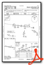
VFR Chart of 4I3
Sectional Charts at SkyVector.com
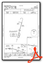
IFR Chart of 4I3
Enroute Charts at SkyVector.com
Location Information for 4I3
Coordinates: N40°19.73' / W82°31.56'Located 04 miles SW of Mount Vernon, Ohio on 386 acres of land. View all Airports in Ohio.
Surveyed Elevation is 1191 feet MSL.
Operations Data
|
|
Airport Communications
| AWOS-3PT: | 126.05 Tel. 740-397-6297 |
|---|---|
| COLUMBUS APPROACH: | 125.95 317.775 |
| COLUMBUS DEPARTURE: | 125.95 317.775 |
| IC: | 125.95 317.775 |
| CLEARANCE DELIVERY: | 119.45 |
| UNICOM: | 123.050 |
| CTAF: | 123.050 |
| ASOS at VTA (18.4 S): | 121.125 740-522-1066 |
| AWOS-3PT at 4I9 (18.9 NW): | 121.4 419-947-1039 |
| D-ATIS at CMH (26.1 SW): | 124.6 |
Nearby Navigation Aids
|
| ||||||||||||||||||||||||||||||||||||||||||||||||||||||||||||


Runway 10/28
| Dimensions: | 5504 x 100 feet / 1678 x 30 meters | |
|---|---|---|
| Surface: | Asphalt / Grooved in Good Condition | |
| Weight Limits: | S-55, D-100 | |
| Edge Lighting: | Medium Intensity | |
| Runway 10 | Runway 28 | |
| Coordinates: | N40°19.80' / W82°32.15' | N40°19.67' / W82°30.98' |
| Elevation: | 1187.3 | 1184.4 |
| Traffic Pattern: | Left | Left |
| Runway Heading: | 98° True | 278° True |
| Markings: | Non-Precision Instrument in good condition. | Non-Precision Instrument in good condition. |
| Glide Slope Indicator | P4L (3.00° Glide Path Angle) | P4L (3.00° Glide Path Angle) |
| REIL: | Yes | Yes |
| Obstacles: | 126 ft Trees 3188 ft from runway, 60 ft left of center | 51 ft Trees 1962 ft from runway, 65 ft left of center |
Services Available
| Fuel: | 100LL (blue), Jet A+ |
|---|---|
| Transient Storage: | Hangars,Tiedowns |
| Airframe Repair: | MAJOR |
| Engine Repair: | MAJOR |
| Bottled Oxygen: | NONE |
| Bulk Oxygen: | NONE |
| Other Services: | CROP DUSTING SERVICES,PILOT INSTRUCTION,AIRCRAFT RENTAL |
Ownership Information
| Ownership: | Publicly owned | |
|---|---|---|
| Owner: | KNOX CO ARPT AUTHORITY | |
| 6481 KINNEY RD | ||
| MOUNT VERNON, OH 43050-9301 | ||
| 740-397-9647 | ||
| Manager: | JOSH WYNN | KNOXAIRPORT@EMBARQMAIL.COM. |
| 6481 KINNEY RD | ||
| MOUNT VERNON, OH 43050-9301 | ||
| 740-397-9647 | ||
Other Remarks
- DEER, BIRDS, & OTR WILDLIFE ON & INVOF ARPT.
- 0LL FUEL AVBL H24 SELF SER VIA CREDIT CARD.
- ACTVT REIL RWY 10 & 28; MIRL RWY 10/28 - CTAF. PAPI RWY 10 & 28 OPR CONSLY.
Weather Minimums


Instrument Approach Procedure (IAP) Charts

Nearby Airports with Instrument Procedures
| ID | Name | Heading / Distance | ||
|---|---|---|---|---|
 |
KVTA | Licking County Regional Airport | 170° | 18.5 |
|
4I9 | Morrow County Airport | 308° | 18.9 |
|
KCMH | John Glenn Columbus International Airport | 220° | 26.1 |
|
KGQQ | Galion Municipal Airport | 340° | 27.0 |
|
KDLZ | Delaware Municipal/Jim Moore Field Airport | 263° | 27.1 |
|
10G | Holmes County Airport | 064° | 28.9 |
|
KOSU | Ohio State University Airport | 239° | 29.3 |
|
KMFD | Mansfield Lahm Regional Airport | 000° | 29.5 |
|
KMNN | Marion Municipal Airport | 305° | 30.0 |
|
I40 | Richard Downing Airport | 091° | 30.9 |
|
12G | Shelby Community Airport | 346° | 33.5 |
|
17G | Port Bucyrus/Crawford County Airport | 323° | 34.0 |
Airport Images
Do you have a recent image of this airport? Upload it here!


