Login
Register


P13
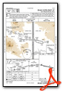
San Carlos Apache Airport
Official FAA Data Effective 2025-12-25 0901Z
Chart Supplement

VFR Chart of P13
Sectional Charts at SkyVector.com
IFR Chart of P13
Enroute Charts at SkyVector.com
Location Information for P13
Coordinates: N33°21.19' / W110°40.04'Located 07 miles SE of Globe, Arizona on 185 acres of land. View all Airports in Arizona.
Surveyed Elevation is 3260 feet MSL.
Operations Data
|
|
Airport Communications
| AWOS-3: | 120.075 Tel. 928-475-5560 |
|---|---|
| CTAF: | 122.800 |
| UNICOM: | 122.800 |
| AWOS-3PT at E24 (41.6 NE): | 119.225 928-338-3411 |
| AWOS-3PT at E77 (43.2 S): | 134.125 520-385-4238 |
| AWOS-3PT at P08 (45.7 SW): | 119.350 520-723-4920 |
- APCH/DEP SVC PRVDD BY ALBUQUERQUE ARTCC (ABQ) ON FREQS 125.4/269.3 (GLOBE NR 2 RCAG).
- COMMUNICATIONS PRVDD BY PRESCOTT RADIO ON FREQ 122.5 (GLOBE RCO).
Nearby Navigation Aids
|
| ||||||||||||||||||||||||||||||||||||


Runway 09/27
PRIM SFC 6-15 FT BRUSH 60-250 FT FM CNTRLN S OF RWY; BRUSH 75-250 FT FM CNTRLN N OF CNTRLN. | ||
| Dimensions: | 6500 x 100 feet / 1981 x 30 meters | |
|---|---|---|
| Surface: | Asphalt / Porous Friction Course in Fair Condition | |
| Weight Limits: | S-60 | |
| Edge Lighting: | Medium Intensity | |
| Runway 09 | Runway 27 | |
| Coordinates: | N33°21.30' / W110°40.67' | N33°21.08' / W110°39.42' |
| Elevation: | 3260.8 | 3181.1 |
| Traffic Pattern: | Left | Right |
| Runway Heading: | 102° True | 282° True |
| Markings: | Non-Precision Instrument in fair condition. | Non-Precision Instrument in fair condition. |
| Glide Slope Indicator | P2L (3.00° Glide Path Angle) | P2L (3.00° Glide Path Angle) |
| REIL: | Yes | Yes |
Services Available
| Fuel: | 100LL (blue), Jet-A |
|---|---|
| Transient Storage: | Tiedowns |
| Airframe Repair: | NOT AVAILABLE |
| Engine Repair: | NOT AVAILABLE |
| Bottled Oxygen: | NOT AVAILABLE |
| Bulk Oxygen: | NOT AVAILABLE |
Ownership Information
| Ownership: | Publicly owned | |
|---|---|---|
| Owner: | SAN CARLOS APACHE TRIBE | |
| PO BOX O | ||
| SAN CARLOS, AZ 85550 | ||
| 928-475-2361 | ||
| Manager: | MARVIN MULL | |
| C/O SAN CARLOS APACHE TRIBE, P.O. BOX O | ||
| SAN CARLOS, AZ 85550 | ||
| 928-475-3222 | 928-475-5563 & 928-812-5790. | |
Other Remarks
- THIS AIRPORT HAS BEEN SURVEYED BY THE NATIONAL GEODETIC SURVEY.
- TWO HILLS S.
- RWY HOLD & TWY EXIT SIGNS OTS INDEFLY.
- PARL TWY HAS 2-5 IN CRACKS.
- ACTVT REIL RWY 09 & 27; PAPI RWY 09 & 27; MIRL RWY 09/27 - CTAF.
Weather Minimums
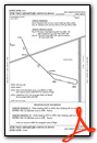
Instrument Approach Procedure (IAP) Charts
Departure Procedure Obstacles (DPO) Charts
Nearby Airports with Instrument Procedures
| ID | Name | Heading / Distance | ||
|---|---|---|---|---|
 |
P08 | Coolidge Municipal Airport | 237° | 45.7 |
|
KIWA | Mesa Gateway Airport | 267° | 49.7 |
|
KFFZ | Falcon Field Airport | 277° | 53.7 |
|
KCHD | Chandler Municipal Airport | 265° | 57.7 |
|
KSAD | Safford Regional/1lt Duane Spalsbury Field Airport | 119° | 60.0 |
|
KCGZ | Casa Grande Municipal Airport | 247° | 60.3 |
|
P19 | Stellar Airpark Airport | 267° | 62.8 |
|
KAVQ | Marana Regional Airport | 206° | 63.0 |
|
KPAN | Payson Airport | 328° | 63.7 |
|
KSOW | Show Low Regional Airport | 031° | 63.9 |
|
KSDL | Scottsdale Airport | 284° | 64.4 |
|
KPHX | Phoenix Sky Harbor International Airport | 274° | 67.7 |
Airport Images
 taken from the northeast looking southwest, late morning.")
By: keeganm


Comments
100LL is available again. $4
100LL is available again. $4.00 per gallon as of 02/02/2018.
Gas?
FAA Notams say no gas available. 6/25/2018
Fredrich A Clarkson
Unavailability of fuel
Fuel was unavailable on 8/4/2018 despite being advertised as for sale. None of the 3 telephone numbers for manager or owner was answered over multiple hours.
A call to the San Carlos police department for help was graciously answered, but despite being assured that "someone was on the way to help," noone ever showed up to help.
My experience over several years at this facility tells me to avoid ever expecting to get fuel here.
As of 8-26-18 100LL is still
As of 8-26-18 100LL is still not available