Login
Register
VEL
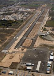
Vernal Regional Airport
Official FAA Data Effective 2024-11-28 0901Z
VFR Chart of KVEL
Sectional Charts at SkyVector.com
IFR Chart of KVEL
Enroute Charts at SkyVector.com
Location Information for KVEL
Coordinates: N40°26.16' / W109°30.69'Located 01 miles SE of Vernal, Utah on 393 acres of land. View all Airports in Utah.
Surveyed Elevation is 5274 feet MSL.
Operations Data
|
|
Airport Communications
| ASOS: | 118.125 Tel. 435-781-1224 |
|---|---|
| CTAF: | 122.700 |
| UNICOM: | 122.700 |
| AWOS-3P at 74V (26.4 W): | 118.975 435-722-4201 |
| AWOS-3PT at 40U (34.0 N): | 119.250 435-784-3123 |
| AWOS-3PT at 4V0 (40.0 SE): | 119.025 970-878-3979 |
- APCH/DEP CTL SVC PRVDD BY SALT LAKE ARTCC (ZLC) ON 119.95/377.15 MYTON RCAG).
Nearby Navigation Aids
|
| ||||||||||||||||||||||||||||||||||||
Runway 17/35
| Dimensions: | 7000 x 100 feet / 2134 x 30 meters | |
|---|---|---|
| Surface: | Asphalt / Grooved in Excellent Condition | |
| Weight Limits: | 18 /F/C/X/T, S-45, D-55 | |
| Edge Lighting: | Medium Intensity | |
| Runway 17 | Runway 35 | |
| Coordinates: | N40°26.74' / W109°30.70' | N40°25.59' / W109°30.67' |
| Elevation: | 5267.8 | 5274.2 |
| Traffic Pattern: | Left | Left |
| Runway Heading: | 179° True | 359° True |
| Declared Distances: | TORA:7000 | TORA:7000 |
| Markings: | Non-Precision Instrument in good condition. | Non-Precision Instrument in good condition. |
| Glide Slope Indicator | P4L (3.00° Glide Path Angle) | P4L (3.00° Glide Path Angle) |
| REIL: | Yes | Yes |
| Obstacles: | 33 ft Pole 586 ft from runway, 367 ft left of center | 44 ft Trees 1094 ft from runway, 203 ft right of center |
Services Available
| Fuel: | 100LL (blue), Jet-A |
|---|---|
| Transient Storage: | Hangars,Tiedowns |
| Airframe Repair: | MAJOR |
| Engine Repair: | MAJOR |
| Bottled Oxygen: | NOT AVAILABLE |
| Bulk Oxygen: | HIGH/LOW |
| Other Services: | AIR FREIGHT SERVICES,PILOT INSTRUCTION,AIRCRAFT RENTAL |
Ownership Information
| Ownership: | Publicly owned | |
|---|---|---|
| Owner: | UINTAH CO AND VERNAL CITY | |
| 152 E 100 N. | ||
| VERNAL, UT 84078 | ||
| (435) 781-0770 | ||
| Manager: | KEN CAMPBELL | |
| 730 EAST 800 S. | ||
| VERNAL, UT 84078 | ||
| (435) 789-3400 | ||
Other Remarks
- RWY 07/25 DECOMMISSIONED.
- FOR CD IF UNA TO CTC ON FSS FREQ, CTC SALT LAKE ARTCC AT 801-320-2568.
- COLD TEMPERATURE AIRPORT. ALTITUDE CORRECTION REQUIRED AT OR BELOW -26C.
- ACTVT REIL RWY 17 & 35; MIRL RWY 17/35 - CTAF. PAPI RWY 17 & 35 ON CONSLY.
Weather Minimums
Instrument Approach Procedure (IAP) Charts
Nearby Airports with Instrument Procedures
| ID | Name | Heading / Distance | ||
|---|---|---|---|---|
 |
74V | Roosevelt Municipal Airport | 249° | 26.5 |
 |
4V0 | Rangely Airport | 120° | 40.0 |
 |
KFBR | Fort Bridger Airport | 324° | 70.4 |
 |
KRKS | Southwest Wyoming Regional Airport | 016° | 72.3 |
 |
KPUC | Carbon County Regional/Buck Davis Field Airport | 229° | 75.5 |
 |
KEEO | Meeker Coulter Field Airport | 106° | 78.2 |
 |
KEVW | Evanston-Uinta County Burns Field Airport | 306° | 85.7 |
 |
KHCR | Heber Valley Airport | 272° | 87.9 |
 |
KCAG | Craig-Moffat Airport | 087° | 91.2 |
 |
KGJT | Grand Junction Regional Airport | 149° | 91.1 |
 |
69V | Huntington Municipal Airport | 225° | 91.5 |
 |
U34 | Green River Municipal Airport | 200° | 94.4 |


