Login
Register


9N3
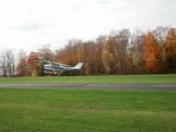
Seamans Field Airport
Official FAA Data Effective 2026-01-22 0901Z
Chart Supplement

VFR Chart of 9N3
Sectional Charts at SkyVector.com
IFR Chart of 9N3
Enroute Charts at SkyVector.com
Location Information for 9N3
Coordinates: N41°35.36' / W75°45.36'Located 02 miles N of Factoryville, Pennsylvania on 75 acres of land. View all Airports in Pennsylvania.
Estimated Elevation is 1209 feet MSL.
Operations Data
|
|
Airport Communications
| WILKES-BARRE APPROACH: | 120.95 256.7 |
|---|---|
| WILKES-BARRE DEPARTURE: | 120.95 256.7 |
| UNICOM: | 122.700 |
| CTAF: | 122.700 |
| ATIS at AVP (15.1 S): | 135.75 |
| ASOS at AVP (15.4 S): | 570-456-5433 |
| ASOS at MPO (32.0 SE): | 120.275 570-839-1584 |
Nearby Navigation Aids
|
| ||||||||||||||||||||||||||||||||||||||||||||||||||||||


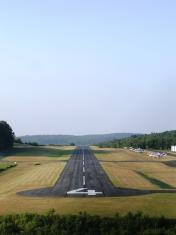
Runway 04/22
| Dimensions: | 2500 x 50 feet / 762 x 15 meters | |
|---|---|---|
| Surface: | Asphalt in Good Condition | |
| Edge Lighting: | Low Intensity | |
| Runway 04 | Runway 22 | |
| Coordinates: | N41°35.14' / W75°45.50' | N41°35.51' / W75°45.28' |
| Elevation: | 1184.2 | 1203.4 |
| Traffic Pattern: | Left | Left |
| Runway Heading: | 24° True | 204° True |
| Markings: | Non-Precision Instrument in good condition. | Basic in good condition. |
Services Available
| Fuel: | 100LL (blue) |
|---|---|
| Transient Storage: | Hangars,Tiedowns |
| Airframe Repair: | NONE |
| Engine Repair: | NONE |
| Bottled Oxygen: | NONE |
| Bulk Oxygen: | NONE |
Ownership Information
| Ownership: | Privately Owned | |
|---|---|---|
| Owner: | RMB AVIATION LLC | |
| 65 WINDSOCK LANE | ||
| FACTORYVILLE, PA 18419 | ||
| 570-945-5125 | ||
| Manager: | JASON CORBY | |
| 65 WINDSOCK LANE | ||
| FACTORYVILLE, PA 18419 | ||
| 570-945-5125 | ||
Other Remarks
- THIS AIRPORT HAS BEEN SURVEYED BY THE NATIONAL GEODETIC SURVEY.
- FOR CD CTC WILKES-BARRE APCH AT 570-655-2084.
Weather Minimums
Instrument Approach Procedure (IAP) Charts

Nearby Airports with Instrument Procedures
| ID | Name | Heading / Distance | ||
|---|---|---|---|---|
 |
KAVP | Wilkes-Barre/Scranton International Airport | 174° | 15.1 |
|
KWBW | Wilkes-Barre Wyoming Valley Airport | 193° | 18.0 |
|
N30 | Cherry Ridge Airport | 100° | 23.2 |
|
KMPO | Pocono Mountains Regional Airport | 147° | 32.0 |
|
N27 | Bradford County Airport | 286° | 32.4 |
|
KCZG | Tri-Cities Airport | 332° | 33.1 |
|
KHZL | Hazleton Regional Airport | 196° | 37.7 |
|
KBGM | Greater Binghamton/Edwin A Link Field Airport | 344° | 38.5 |
|
KMSV | Sullivan County International Airport | 080° | 43.8 |
|
N23 | Sidney Municipal Airport | 019° | 45.4 |
|
22N | Jake Arner Memorial Airport | 180° | 46.8 |
|
N13 | Bloomsburg Municipal Airport | 221° | 46.9 |