Login
Register


CGS
College Park Airport
Official FAA Data Effective 2024-04-18 0901Z
Chart Supplement

VFR Chart of KCGS
Sectional Charts at SkyVector.com
IFR Chart of KCGS
Enroute Charts at SkyVector.com
Location Information for KCGS
Coordinates: N38°58.83' / W76°55.33'Located 01 miles SE of College Park, Maryland on 70 acres of land. View all Airports in Maryland.
Surveyed Elevation is 48 feet MSL.
Operations Data
|
|
Airport Communications
| AWOS-3: | 121.225 Tel. 301-864-5497 |
|---|---|
| POTOMAC APPROACH: | 124.7 125.65 ;DC FRZ 338.2 348.725 |
| POTOMAC DEPARTURE: | 124.7 125.65 ;DC FRZ 338.2 348.725 |
| IRONS STAR: | 126.4 282.375 |
| CTAF: | 122.975 |
| UNICOM: | 122.975 |
| ASOS at DCA (9.4 SW): | 132.65 703-418-1177 |
| D-ATIS at DCA (9.4 SW): | 132.65 |
| AWOS-3 at FME (9.9 NE): | 123.925 |
Nearby Navigation Aids
|
| ||||||||||||||||||||||||||||||||||||||||||||||||||||||||||||


Runway 15/33
| Dimensions: | 2980 x 60 feet / 908 x 18 meters | |
|---|---|---|
| Surface: | Asphalt in Good Condition | |
| Edge Lighting: | Medium Intensity | |
| Runway 15 | Runway 33 | |
| Coordinates: | N38°59.01' / W76°55.54' | N38°58.65' / W76°55.12' |
| Elevation: | 48.9 | 38.5 |
| Traffic Pattern: | Left | |
| Runway Heading: | 138° True | 318° True |
| Displaced Threshold: | 564 Feet | 171 Feet |
| Declared Distances: | TORA:2980 TODA:2980 ASDA:2740 LDA:2176 | TORA:2980 TODA:2980 ASDA:2846 LDA:2675 |
| Markings: | Non-Precision Instrument in good condition. | Non-Precision Instrument in good condition. |
| Glide Slope Indicator | P2L (4.00° Glide Path Angle) | P2R (4.00° Glide Path Angle) |
| REIL: | Yes | Yes |
| Obstacles: | 48 ft Trees 383 ft from runway, 103 ft right of center APCH SLOPE AT CL 20:1 FM DSPLCD THR AND CENTERLINE. +33 FT RAILROAD, 117 FM THR WITH OBS LTS. |
116 ft Trees 1390 ft from runway, 122 ft right of center APCH SLOPE AT CL 20:1 FM DSPLCD THR AND CENTERLINE. +15 FT FENCE 87 FT R AT THR; -6 FT DITCH 65 FT L AT THR. |
Services Available
| Fuel: | 100LL (blue), Jet A-1+ |
|---|---|
| Transient Storage: | Tiedowns |
| Airframe Repair: | NONE |
| Engine Repair: | NONE |
| Bottled Oxygen: | NONE |
| Bulk Oxygen: | NONE |
Ownership Information
| Ownership: | Publicly owned | |
|---|---|---|
| Owner: | MNCPPC | THE MARYLAND NATIONAL CAPITAL PARK & PLANNING CMSN. |
| 6611 KENILWORTH AVENUE | ||
| RIVERDALE, MD 20737 | ||
| 301-699-2255 | ||
| Manager: | LEE SOMMER | |
| 1909 CORPORAL FRANK SCOTT DRIVE | ||
| COLLEGE PARK, MD 20740 | ||
| 301-864-5844 | ||
Operational Statistics
| Single Engine Aircraft Based on Field: | 30 | Statistics collected for 12 month period ending 2023-08-29 | |
|---|---|---|---|
| Multi-Engine Aircraft Based on Field: | none | Annual Commercial Operations: | none |
| Jet Aircraft Based on Field: | none | Annual Commuter Operations: | none |
| Helicopters Based on Field: | 4 | Annual Air Taxi Operations: | 23 |
| Military Aircraft Based on Field: | none | Annual Military Operations: | 78 |
| Gliders Based on Field: | 1 | Annual GA Local Operations: | 2979 |
| Ultralights Based on Field: | none | Annual GA Itinerant Operations: | 543 |
Other Remarks
- NO TKOFS 2200-0700; LNDG ONLY.
- TSNT PRKG: FIRST 4 HRS FREE; FEE AFT, WAIVED W/MIN FUEL PURCHASE; OVNGT FEE.
- HEL RAMP FEE; WAIVED IF UNDER 3500 LBS OR MIN FUEL PURCHASE.
- ACFT HANDLING FEE IF RELOCATION TO/FROM FUEL AREA RQRD BY ARPT PSNL.
- BLDG 0.1 NM S OF ARPT 23 FT AGL LGTD.
- NO ACFT OVR 12500 LBS MFR GWT; HELS ONLY WITH 24 HR PPR - CALL AMGR 301-864-5844.
- NOISE ABATEMENT PROCEDURES IN EFFECT CTC AMGR 301-864-5844.
- AER 15 HEAVY SMOKE & FIREFIGHTING TRAINING OPNS INTERMITTENTLY IN PROGRESS.
- NO STUDENT TGL OR SOLO OPNS PERMITTED.
- DEER AND OTHER WILDLIFE ON & INVOF ARPT.
- COMPLIANCE WITH 14CFR SECTION 93.335 IS REQUIRED BEFORE PILOTS MAY OPERATE TO/FROM THIS AIRPORT.
- FOR CD CTC POTOMAC APCH AT 866-599-3874.
- ACTVT REIL RWY 15 & 33; PAPI RWY 15 & 33; MIRL RWY 15/33 - CTAF.
Weather Minimums
Instrument Approach Procedure (IAP) Charts
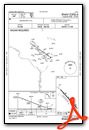
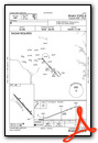
Nearby Airports with Instrument Procedures
| ID | Name | Heading / Distance | ||
|---|---|---|---|---|
 |
W00 | Freeway Airport | 108° | 7.4 |
|
KDCA | Ronald Reagan Washington Ntl Airport | 215° | 9.4 |
|
KFME | Tipton Airport | 050° | 9.9 |
|
KADW | Joint Base Andrews Airport | 165° | 10.5 |
|
KVKX | Potomac Airfield Airport | 186° | 14.0 |
|
KGAI | Montgomery County Airpark Airport | 314° | 16.0 |
|
KBWI | Baltimore/Washington International Thurgood Marshall Airport | 045° | 16.6 |
|
KANP | Lee Airport | 097° | 16.7 |
|
W50 | Davis Airport | 326° | 19.0 |
|
KDAA | Davison AAF Airport | 217° | 20.0 |
|
2W5 | Maryland Airport | 197° | 24.0 |
|
KIAD | Washington Dulles International Airport | 265° | 25.2 |


