Login
Register


JZI
Charleston Exec Airport
Official FAA Data Effective 2026-01-22 0901Z
Chart Supplement

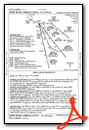
VFR Chart of KJZI
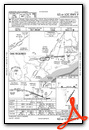
Sectional Charts at SkyVector.com
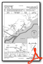
IFR Chart of KJZI
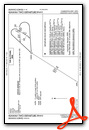
Enroute Charts at SkyVector.com
Location Information for KJZI
Coordinates: N32°42.06' / W80°0.19'Located 06 miles SW of Charleston, South Carolina on 1373 acres of land. View all Airports in South Carolina.
Surveyed Elevation is 18 feet MSL.
Operations Data
|
|
Airport Communications
| AWOS-3: | 123.775 Tel. 843-559-3123 |
|---|---|
| CHARLESTON APPROACH: | 120.7 306.925 |
| CHARLESTON DEPARTURE: | 120.7 306.925 |
| CLEARANCE DELIVERY: | 119.85 |
| UNICOM: | 122.800 |
| CTAF: | 122.800 |
| AWOS-1 at SC80 (5.5 NE): | 122.975 843-985-0983 |
| ASOS at CHS (12.0 N): | 843-214-2525 |
| D-ATIS at CHS (12.0 N): | 124.75 |
Nearby Navigation Aids
|
| ||||||||||||||||||||||||||||||||||||||||||||||||||||||||||||


Runway 09/27
| Dimensions: | 5350 x 100 feet / 1631 x 30 meters | |
|---|---|---|
| Surface: | Concrete / Grooved in Excellent Condition | |
| Weight Limits: | S-60, D-100 | |
| Edge Lighting: | High Intensity | |
| Runway 09 | Runway 27 | |
| Coordinates: | N32°42.29' / W80°0.77' | N32°42.30' / W79°59.73' |
| Elevation: | 18.6 | 11.1 |
| Traffic Pattern: | Left | Left |
| Runway Heading: | 89° True | 269° True |
| Displaced Threshold: | 350 Feet | |
| Markings: | Precision Instrument in good condition. | Non-Precision Instrument in good condition. |
| Glide Slope Indicator | P4L (3.00° Glide Path Angle) | P4R (3.00° Glide Path Angle) |
| REIL: | Yes | Yes |
| Obstacles: | 110 ft Trees 3589 ft from runway, 781 ft left of center | 16 ft Brush 438 ft from runway, 250 ft right of center APPROACH SLOPE TO DISPLACED THR. IS 50:1. |
Runway 04/22
| Dimensions: | 4313 x 150 feet / 1315 x 46 meters | |
|---|---|---|
| Surface: | Concrete in Good Condition | |
| Weight Limits: | S-45, D-56 | |
| Edge Lighting: | Medium Intensity | |
| Runway 04 | Runway 22 | |
| Coordinates: | N32°41.47' / W80°0.35' | N32°42.07' / W79°59.90' |
| Elevation: | 9.8 | 11.1 |
| Traffic Pattern: | Left | Left |
| Runway Heading: | 32° True | 212° True |
| Markings: | Non-Precision Instrument in good condition. | Basic in good condition. |
| Obstacles: | 83 ft Tree 2221 ft from runway, 50 ft right of center TREE LINE 231 FEET EAST OF RWY 4 THLD 21 FEET HIGH |
|
Services Available
| Fuel: | 100LL (blue), Jet-A |
|---|---|
| Transient Storage: | Hangars,Tiedowns |
| Airframe Repair: | MINOR |
| Engine Repair: | MINOR |
| Bottled Oxygen: | NOT AVAILABLE |
| Bulk Oxygen: | NONE |
| Other Services: | PILOT INSTRUCTION,AIRCRAFT RENTAL |
Ownership Information
| Ownership: | Publicly owned | |
|---|---|---|
| Owner: | CHARLESTON CO AVN AUTHORITY | |
| 5500 INTL BLVD, # 101 | ||
| CHARLESTON, SC 29418-6911 | ||
| 843-767-7000 | ||
| Manager: | ELLIOTT SUMMEY | |
| 5500 INTERNATIONAL BLVD, #101 | ||
| CHARLESTON, SC 29418 | ||
| 843-767-7000 | ||
Other Remarks
- DEER & BIRDS ON & INVOF ARPT.
- FOR CD CTC CHARLESTON APCH AT 843-414-2832.
- SR-SS, TO ACTVT AND INCR INTST REIL RWY 09 & 27; HIRL RWY 09/27; MIRL RWY 04/22 - CTAF. SR-SS, PAPI RWY 09 & 27 OPR CONSLY. SS-SR, REIL RWY 09 & 27; PAPI RWY 09 & 27; HIRL RWY 09/27 OPR CONSLY, TO INCR INTST - CTAF. SS-SR, TO ACTVT MIRL RWY 04/22 - CTAF.
Weather Minimums

Standard Terminal Arrival (STAR) Charts


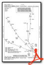
Instrument Approach Procedure (IAP) Charts


Departure Procedure (DP) Charts

Nearby Airports with Instrument Procedures
| ID | Name | Heading / Distance | ||
|---|---|---|---|---|
 |
KCHS | Charleston AFB/International Airport | 350° | 12.0 |
|
KLRO | Mt Pleasant Regional-Faison Field Airport | 043° | 16.2 |
|
KDYB | Summerville Airport | 327° | 25.8 |
|
KMKS | Berkeley County Airport | 356° | 29.0 |
|
KRBW | Lowcountry Regional Airport | 292° | 34.8 |
|
KARW | Beaufort Exec Airport | 241° | 36.4 |
|
6J2 | St George Airport | 319° | 39.1 |
|
KHXD | Hilton Head Airport | 231° | 45.3 |
|
KGGE | Georgetown County Airport | 043° | 50.2 |
|
KPHH | Robert F Swinnie Airport | 028° | 51.0 |
|
KCKI | Williamsburg Regional Airport | 006° | 61.3 |
|
KOGB | Orangeburg Municipal Airport | 316° | 62.5 |
Airport Images
Do you have a recent image of this airport? Upload it here!


