Login
Register


MHR
Sacramento Mather Airport
Official FAA Data Effective 2024-04-18 0901Z
Chart Supplement

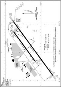
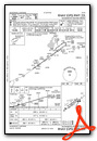
KMHR Airport Diagram
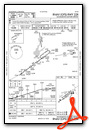
VFR Chart of KMHR
Sectional Charts at SkyVector.com
IFR Chart of KMHR
Enroute Charts at SkyVector.com
Location Information for KMHR
Coordinates: N38°33.32' / W121°17.83'Located 10 miles E of Sacramento, California on 2875 acres of land. View all Airports in California.
Surveyed Elevation is 98 feet MSL.
TPA FOR PISTON ACFT 1000 FT AGL; TURBINE ACFT 1800 FT AGL.
Operations Data
|
|
Airport Communications
| ATIS: | 118.325 |
|---|---|
| AWOS-3PT: | 118.325 Tel. 916-366-3371 |
| MATHER TOWER: | 120.65 282.25 |
| MATHER GROUND: | 121.85 307.9 |
| NORCAL APPROACH: | 127.4 317.5 |
| NORCAL DEPARTURE: | 127.4 317.5 |
| CLEARANCE DELIVERY: | 121.85 307.9 |
| CTAF: | 120.650 |
| UNICOM: | 122.950 |
| AWOS-3 at MCC (8.3 NW): | 125.975 916-641-1272 |
| ATIS at SAC (9.6 W): | 125.5 |
| ASOS at SAC (9.8 W): | 916-421-0923 |
- ATCT OPER BY SERCO.
- COMMUNICATIONS PRVDD BY RANCHO MURIETA RADIO ON FREQ 122.4 (SACRAMENTO RCO).
Nearby Navigation Aids
|
| ||||||||||||||||||||||||||||||||||||


Runway 04R/22L
| Dimensions: | 11301 x 150 feet / 3445 x 46 meters | |
|---|---|---|
| Surface: | Asphalt-Concrete in Good Condition | |
| Weight Limits: | S-160, D-280, ST-500
SWL 65/PSI 640.
| |
| Edge Lighting: | High Intensity | |
| Runway 04R | Runway 22L | |
| Coordinates: | N38°32.68' / W121°18.81' | N38°33.78' / W121°16.90' |
| Elevation: | 77.3 | 98.3 |
| Traffic Pattern: | Right | Left |
| Runway Heading: | 54° True | 234° True |
| Markings: | Precision Instrument in good condition. | Precision Instrument in good condition. |
| Glide Slope Indicator | V4L (3.00° Glide Path Angle) | V4L (3.00° Glide Path Angle) |
| RVR Equipment | Touchdown Midfield Rollout | Touchdown Midfield Rollout |
| Approach Lights: | MALSR 1,400 Foot Medium-intensity Approach Lighting System with runway alignment indicator lights. | |
Runway 04L/22R
| Dimensions: | 6081 x 150 feet / 1853 x 46 meters | |
|---|---|---|
| Surface: | Asphalt in Good Condition | |
| Weight Limits: | S-90, D-105, ST-190 | |
| Edge Lighting: | Medium Intensity | |
| Runway 04L | Runway 22R | |
| Coordinates: | N38°33.18' / W121°18.30' | N38°33.77' / W121°17.28' |
| Elevation: | 80.9 | 94.1 |
| Traffic Pattern: | Left | Right |
| Runway Heading: | 54° True | 234° True |
| Markings: | Non-Precision Instrument in good condition. | Non-Precision Instrument in good condition. |
Helipad H2
| Dimensions: | 100 x 100 feet / 30 x 30 meters | |
|---|---|---|
| Surface: | Asphalt in Fair Condition | |
| Coordinates: | N38°33.37' / W121°17.13' | N0°0.00' / E0°0.00' |
| Elevation: | 92.0 | |
Helipad H1
| Dimensions: | 30 x 30 feet / 9 x 9 meters | |
|---|---|---|
| Surface: | Asphalt in Fair Condition | |
| Coordinates: | N38°33.77' / W121°17.48' | N0°0.00' / E0°0.00' |
| Elevation: | 95.0 | |
Services Available
| Fuel: | 100LL (blue), Jet-A |
|---|---|
| Transient Storage: | Hangars,Tiedowns |
| Airframe Repair: | MAJOR |
| Engine Repair: | MAJOR |
| Bottled Oxygen: | NOT AVAILABLE |
| Bulk Oxygen: | LOW |
| Other Services: | AIR FREIGHT SERVICES,CARGO HANDLING SERVICES |
Ownership Information
| Ownership: | Publicly owned | |
|---|---|---|
| Owner: | COUNTY OF SACRAMENTO | |
| 6900 AIRPORT BLVD. | ||
| SACRAMENTO, CA 95837 | ||
| 916-875-7077 | ||
| Manager: | LARRY FLESHMAN | |
| 10425 NORDEN AVE | ||
| MATHER, CA 95655 | ||
| 916-875-6760 | ||
Operational Statistics
| Single Engine Aircraft Based on Field: | 10 | Statistics collected for 12 month period ending 2018-12-31 | |
|---|---|---|---|
| Multi-Engine Aircraft Based on Field: | 1 | Annual Commercial Operations: | 4781 |
| Jet Aircraft Based on Field: | none | Annual Commuter Operations: | none |
| Helicopters Based on Field: | none | Annual Air Taxi Operations: | 12493 |
| Military Aircraft Based on Field: | 41 | Annual Military Operations: | 31702 |
| Gliders Based on Field: | none | Annual GA Local Operations: | 13713 |
| Ultralights Based on Field: | none | Annual GA Itinerant Operations: | 36778 |
Other Remarks
- BE ADVISED RY 4L THLD LGTS ARE NON-STANDARD.
- FOR CD WHEN ATCT IS CLSD CTC NORCAL APCH AT 916-361-6874.
- TWY D1 CLSD TO ACFT WITH WINGSPAN MORE THAN 69 FT.
- RY 22L CALM WIND RY.
- BE ALERT FOR LARGE TRANSPORT ACFT TKOFS & LNDGS AND HIGH PERFORMANCE MILITARY T-38 JETS.
- AVOID NOISE SENSITIVE RESIDENTIAL AREAS NORTH/EAST OF RY 22L ILS FINAL APCH COURSE. TURBOJET NIGHTTIME NOISE ABATEMENT ARRIVAL AND DEPARTURE PROCEDURES IN EFFECT 2200-0700 DAILY.
- PILOT INFORMATION ON NOISE ABATEMENT (916) 874-0359.
- TWY D LTD TO ACFT WITH MAX GWT 50000 LBS OR LESS. TWY D1 LTD TO ACFT WITH MAX GWT OF 50000 LBS OR LESS.
- BIRDS INVOF OF ARPT.
- ACFT ENTERING RY 22R TFC PAT FM THE NORTH SHOULD EXPECT TO FLY BASE LEG EXTENDED 2 MILES FM RY THLD.
- WHEN ATCT CLSD ACTVT MIRL RY 04L/22R, HIRL RY 04R/22L, VASI RYS 04R, 22L AND MALSR RY 22L - CTAF.
- TPA FOR PISTON ACFT 1000 FT AGL; TURBINE ACFT 1800 FT AGL.
Weather Minimums
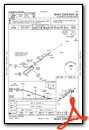
Standard Terminal Arrival (STAR) Charts
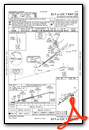
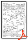
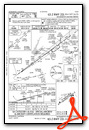
Instrument Approach Procedure (IAP) Charts
Nearby Airports with Instrument Procedures
| ID | Name | Heading / Distance | ||
|---|---|---|---|---|
 |
KMCC | Mc Clellan Airfield Airport | 324° | 8.3 |
|
KSAC | Sacramento Exec Airport | 254° | 9.6 |
|
KSMF | Sacramento International Airport | 301° | 16.2 |
|
1O3 | Lodi Airport | 176° | 21.2 |
|
KLHM | Lincoln Regional/Karl Harder Field Airport | 353° | 21.4 |
|
KEDU | University Airport | 266° | 23.1 |
|
KJAQ | Westover Field Amador County Airport | 114° | 26.0 |
|
KAUN | Auburn Municipal Airport | 022° | 26.0 |
|
KDWA | Yolo County Airport | 273° | 26.4 |
|
KPVF | Placerville Airport | 068° | 27.5 |
|
O41 | Watts-Woodland Airport | 284° | 28.0 |
|
O88 | Rio Vista Municipal Airport | 221° | 29.0 |
Airport Images
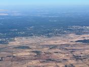
By: CapnG

By: CapnG


