Login
Register


MHV
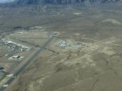
Mojave Air & Space Port/Rutan Field Airport
Official FAA Data Effective 2026-02-19 0901Z
Chart Supplement

KMHV Airport Diagram

VFR Chart of KMHV
Sectional Charts at SkyVector.com
IFR Chart of KMHV
Enroute Charts at SkyVector.com
Location Information for KMHV
Coordinates: N35°3.54' / W118°9.04'Located 01 miles E of Mojave, California on 2998 acres of land. View all Airports in California.
Surveyed Elevation is 2801 feet MSL.
CAT C/D & ALL TBJT ACFT TPA 4301 FT MSL (1500 FT AGL); CAT A/B ACFT TPA 3801 FT MSL (1000 FT AGL); HEL TPA 3301 FT MSL (500 FT AGL) AND USE SOUTH ENTRY AND DEP.
Operations Data
|
|
Airport Communications
| AWOS-3PT: | 132.225 Tel. 661-824-5218 |
|---|---|
| MOJAVE TOWER: | 127.6 288.35 |
| MOJAVE GROUND: | 123.9 |
| JOSHUA APPROACH: | 133.65 348.7 |
| JOSHUA DEPARTURE: | 133.65 348.7 |
| CTAF: | 127.600 |
| AWOS-1 at L71 (8.8 NE): | 120.875 760-373-7670 |
| AWOS-3P at TSP (15.1 W): | 120.025 661-823-0473 |
| ATIS at EDW (15.9 SE): | 269.9 |
- ATCT OWNED BY EAST KERN COUNTY & OPERATED BY BARTON ATC INC.
Nearby Navigation Aids
|
| ||||||||||||||||||||||||||||||||||||

Runway 12/30
| Dimensions: | 12503 x 200 feet / 3811 x 61 meters | |
|---|---|---|
| Surface: | Asphalt in Excellent Condition | |
| Weight Limits: | S-120, D-150, ST-450 | |
| Edge Lighting: | High Intensity | |
| Runway 12 | Runway 30 | |
| Coordinates: | N35°4.15' / W118°9.63' | N35°2.69' / W118°7.86' |
| Elevation: | 2801.3 | 2680.2 |
| Traffic Pattern: | Left | Right |
| Runway Heading: | 135° True | 315° True |
| Displaced Threshold: | 600 Feet | 900 Feet |
| Markings: | Non-Precision Instrument in fair condition. | Non-Precision Instrument in fair condition. |
| Glide Slope Indicator | P4L (3.50° Glide Path Angle) PAPI UNUSBL BYD 2.5 NM. | P4L (3.00° Glide Path Angle) |
| REIL: | Yes | Yes |
| Obstacles: | 375 ft Other 14400 ft from runway, 250 ft left of center WIND TURBINE APPROACH SLOPE 40:1 TO THE DSPLCD THR. |
|
Runway 08/26
| Dimensions: | 7049 x 100 feet / 2149 x 30 meters 300 FT PAVED OVERRUN EAST END OF RY; 300 FT PAVED OVERRUN WEST END OF RY. | |
|---|---|---|
| Surface: | Asphalt in Good Condition | |
| Weight Limits: | S-40, D-60, ST-88 | |
| Edge Lighting: | Medium Intensity | |
| Runway 08 | Runway 26 | |
| Coordinates: | N35°3.55' / W118°9.96' | N35°3.55' / W118°8.55' |
| Elevation: | 2780.4 | 2734.9 |
| Traffic Pattern: | Left | Right |
| Runway Heading: | 90° True | 270° True |
| Markings: | Non-Precision Instrument in good condition. | Non-Precision Instrument in good condition. |
| Glide Slope Indicator | P2L (4.00° Glide Path Angle) | P2L (3.00° Glide Path Angle) |
Runway 04/22
| Dimensions: | 4747 x 60 feet / 1447 x 18 meters | |
|---|---|---|
| Surface: | Asphalt in Excellent Condition | |
| Weight Limits: | S-40, D-60, ST-60 | |
| Edge Lighting: | Medium Intensity | |
| Runway 04 | Runway 22 | |
| Coordinates: | N35°3.58' / W118°9.86' | N35°4.07' / W118°9.11' |
| Elevation: | 2779.9 | 2779.1 |
| Traffic Pattern: | Left | Right |
| Runway Heading: | 52° True | 232° True |
| Markings: | Non-Precision Instrument in good condition. | Non-Precision Instrument in good condition. |
| Glide Slope Indicator | P2L (4.00° Glide Path Angle) | P2L (3.00° Glide Path Angle) |
| Obstacles: | 44 ft Pole 2200 ft from runway | |
Services Available
| Fuel: | 100LL (blue), Jet-A, Jet A+ |
|---|---|
| Transient Storage: | Tiedowns |
| Airframe Repair: | MAJOR |
| Engine Repair: | MAJOR |
| Bottled Oxygen: | NONE |
| Bulk Oxygen: | NONE |
| Other Services: | AVIONICS,PILOT INSTRUCTION |
Ownership Information
| Ownership: | Publicly owned | |
|---|---|---|
| Owner: | MOJAVE AIR AND SPACE PORT | |
| 1434 FLIGHTLINE | ||
| MOJAVE, CA 93501 | ||
| 661-824-2433 | ||
| Manager: | DAVID SMITH | |
| 1434 FLIGHTLINE | ||
| MOJAVE, CA 93501 | ||
| 661-824-2433 | ||
Other Remarks
- BE ALERT TO HIGH SPEED ACTIVITY INVOF ARPT.
- DUE TO RAPIDLY RISING TERRAIN AND WIND TURBINES W - NW OF ARPT, CAT C/D & ALL TURBOJET ACFT LDG RWY 8 MUST REMAIN AT OR ABOVE 4301 FT MSL UNTIL COMMENCING BASE LEG TURN AND AT OR ABOVE 3800 FT MSL UNTIL ESTABLISHED ON A 2.25 NM FINAL.
- TWY F IS CLSD WEST OF TWY A.
- 0LL FUEL AVBL 0700-1700, MON-SAT. OTR TIMES CTC ARPT OPNS ON CTAF OR CALL 661-824-2434; FEE CHARGED.
- FUEL AVBL 0700-1700, MON-SAT. OTR TIMES CTC ARPT OPNS ON CTAF OR CALL 661-824-2434; FEE CHARGED.
- ACTVT REIL RWYS 12 & 30; MIRL RWYS 08/26 & 04/22; HIRL RWY 12/30 - CTAF.
- CAT C/D & ALL TBJT ACFT TPA 4301 FT MSL (1500 FT AGL); CAT A/B ACFT TPA 3801 FT MSL (1000 FT AGL); HEL TPA 3301 FT MSL (500 FT AGL) AND USE SOUTH ENTRY AND DEP.
Weather Minimums

Instrument Approach Procedure (IAP) Charts


Departure Procedure (DP) Charts


Nearby Airports with Instrument Procedures
| ID | Name | Heading / Distance | ||
|---|---|---|---|---|
 |
L71 | California City Municipal Airport | 049° | 8.6 |
|
KEDW | Edwards AFB Airport | 124° | 15.9 |
|
KWJF | General Wm J Fox Airfield Airport | 190° | 19.3 |
|
KPMD | Palmdale Usaf Plant 42 Airport | 172° | 25.9 |
|
KIYK | Inyokern Airport | 023° | 39.2 |
|
L45 | Bakersfield Municipal Airport | 291° | 44.5 |
|
KVCV | Southern California Logistics Airport | 125° | 47.0 |
|
KWHP | Whiteman Airport | 195° | 49.6 |
|
KBFL | Meadows Field Airport | 297° | 49.9 |
|
KBUR | Bob Hope Airport | 191° | 52.4 |
|
KVNY | Van Nuys Airport | 198° | 53.6 |
|
KAPV | Apple Valley Airport | 121° | 55.8 |