Login
Register


S17
Twin Lakes Airport
Official FAA Data Effective 2025-12-25 0901Z
Chart Supplement

VFR Chart of S17
Sectional Charts at SkyVector.com
IFR Chart of S17
Enroute Charts at SkyVector.com
Location Information for S17
Coordinates: N33°38.74' / W81°52.02'Located 04 miles NW of Graniteville, South Carolina on 35 acres of land. View all Airports in South Carolina.
Estimated Elevation is 540 feet MSL.
Operations Data
|
|
Airport Communications
| CTAF: | 122.900 |
|---|---|
| AWOS-3PT at AIK (9.3 E): | 118.025 803-643-8664 |
| ASOS at DNL (13.8 SW): | 135.275 706-481-8629 |
| ATIS at AGS (17.3 S): | 132.75 |
Nearby Navigation Aids
|
| ||||||||||||||||||||||||||||||||||||||||||||||||||||||||||||


Runway 06/24
| Dimensions: | 4000 x 60 feet / 1219 x 18 meters | |
|---|---|---|
| Surface: | Asphalt in Fair Condition | |
| Weight Limits: | S-12 | |
| Edge Lighting: | Non-Standard | |
| Runway 06 | Runway 24 | |
| Traffic Pattern: | Left | Left |
| Displaced Threshold: | 390 Feet | 421 Feet |
| Markings: | Basic in good condition. | Basic in good condition. |
| Obstacles: | 47 ft Tree 510 ft from runway, 149 ft left of center RY 06 APCH RATIO 20:1 TO DSPLCD THLD. |
44 ft Tree 877 ft from runway, 187 ft right of center |
Services Available
| Fuel: | NONE |
|---|---|
| Transient Storage: | NONE |
| Airframe Repair: | NONE |
| Engine Repair: | NONE |
| Bottled Oxygen: | NOT AVAILABLE |
| Bulk Oxygen: | NOT AVAILABLE |
Ownership Information
| Ownership: | Privately Owned | |
|---|---|---|
| Owner: | TIMOTHY RISCHBIETER | |
| 172 CESSNA DRIVE | ||
| TRENTON, SC 29847 | ||
| 518-542-3795 | ||
| Manager: | TIMOTHY RISCHBIETER | |
| 172 CESSNA DRIVE | ||
| TRENTON, SC 29847 | ||
| 518-542-3795 | ||
Other Remarks
- PARKING FOR TSNT ACFT BY PRIOR ARRGMT 803-480-9569.
- CLSD TO ACFT WITH MAX GWT 12,500LBS AND ABOVE.
- FUEL FOR TRANSIENT ACFT BY PRIOR ARRGMNT 803-480-9569.
- FOR CD CTC AUGUSTA APCH AT 706-771-1777. WHEN AUGUSTA APCH CLSD, FOR CD CTC ATLANTA ARTCC AT 770-210-7692.
- ACTVT NON-STD SOLAR MIRL - CTAF.
- ACTVT ROTG BCN - CTAF.
Nearby Airports with Instrument Procedures
| ID | Name | Heading / Distance | ||
|---|---|---|---|---|
 |
KAIK | Aiken Regional Airport | 088° | 9.1 |
|
KDNL | Daniel Field Airport | 218° | 13.8 |
|
KAGS | Augusta Regional At Bush Field Airport | 196° | 17.2 |
|
6J4 | Saluda County Airport | 012° | 17.2 |
|
6J0 | Lexington County Airport | 073° | 32.3 |
|
KHQU | Thomson/Mcduffie County Airport | 258° | 33.3 |
|
KBNL | Barnwell Regional Airport | 133° | 33.4 |
|
KBXG | Burke County Airport | 190° | 36.9 |
|
KGRD | Greenwood County Airport | 338° | 39.0 |
|
KCAE | Columbia Metro Airport | 064° | 41.3 |
|
KEOE | Newberry County Airport | 015° | 41.3 |
|
99N | Bamberg County Airport | 118° | 43.2 |
Airport Images
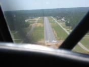
By: jtb1_99


