Login
Register


SC99
Whiteplains Airport
Official FAA Data Effective 2025-12-25 0901Z
VFR Chart of SC99
Sectional Charts at SkyVector.com
IFR Chart of SC99
Enroute Charts at SkyVector.com
Location Information for SC99
Coordinates: N33°57.83' / W81°21.50'Located 05 miles W of Lexington, South Carolina on 10 acres of land. View all Airports in South Carolina.
Estimated Elevation is 524 feet MSL.
Operations Data
|
|
Airport Communications
| CTAF: | 122.900 |
|---|---|
| ATIS at CAE (12.0 E): | 120.15 |
| ASOS at CAE (12.0 E): | 803-369-6879 |
| ASOS at CUB (18.1 E): | 118.675 803-929-0665 |
Nearby Navigation Aids
|
| ||||||||||||||||||||||||||||||||||||||||||||||||||||||||||||


Runway 09/27
| Dimensions: | 3000 x 35 feet / 914 x 11 meters | |
|---|---|---|
| Surface: | Asphalt | |
| Edge Lighting: | Low Intensity | |
| Runway 09 | Runway 27 | |
| Coordinates: | N33°57.83' / W81°21.79' | N33°57.83' / W81°21.20' |
| Elevation: | 524.0 | 490.9 |
| Traffic Pattern: | Right | |
| Runway Heading: | 90° True | 270° True |
| Displaced Threshold: | 293 Feet | |
| Glide Slope Indicator | V2R (3.50° Glide Path Angle) | |
| Obstacles: | 70 ft Trees 230 ft from runway | ft Trees ft from runway |
Services Available
| Fuel: | NONE |
|---|---|
| Transient Storage: | NONE |
| Airframe Repair: | NONE |
| Engine Repair: | NONE |
| Bottled Oxygen: | NONE |
| Bulk Oxygen: | NONE |
Ownership Information
| Ownership: | Privately Owned | |
|---|---|---|
| Owner: | WHITEPLAINS PLANTATION ASSN | |
| 103 WHITEPLAINS DRIVE | ||
| GILBERT, SC 29054 | ||
| 803-567-5332 | ||
| Manager: | WHITEPLAINS PLANTATION ASSN | |
| 103 WHITEPLAINS DRIVE | ||
| GILBERT, SC 29054 | ||
| 803-567-5332 | ||
Other Remarks
- FOR CD CTC COLUMBIA APPROACH 803-822-5242 OR 803-822-5040.
- PVT ARPT, PPR RQRD. CTC ARPT MGR @ 803-567-5332, NO FUEL, NO SVCS, NO PRKG, NO TIE DOWNS.
- LIRL RWY 09/27 OPR DUSK -0000. AFTER 0000 ACTVT LIRL RWY 09/27 - CTAF. ACTVT VASI RWY 27 - CTAF. ALL LGT ACTVT WITH THREE SLOW MIC CLICKS ON CTAF.
- ACTVT ROTG BCN - CTAF.
Nearby Airports with Instrument Procedures
| ID | Name | Heading / Distance | ||
|---|---|---|---|---|
 |
6J0 | Lexington County Airport | 150° | 11.6 |
|
KCAE | Columbia Metro Airport | 097° | 12.0 |
|
KCUB | Jim Hamilton L B Owens Airport | 088° | 18.1 |
|
6J4 | Saluda County Airport | 264° | 21.9 |
|
KFDW | Fairfield County Airport | 030° | 24.5 |
|
KAIK | Aiken Regional Airport | 221° | 24.9 |
|
KEOE | Newberry County Airport | 325° | 25.0 |
|
KMMT | Mc Entire Jngb Airport | 095° | 27.9 |
|
KOGB | Orangeburg Municipal Airport | 140° | 39.3 |
|
99N | Bamberg County Airport | 162° | 41.4 |
|
KBNL | Barnwell Regional Airport | 182° | 42.3 |
|
KGRD | Greenwood County Airport | 293° | 43.4 |
Airport Images
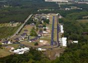
By: Rob Bridgers


