Login
Register


SLE
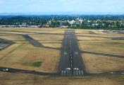
Mcnary Field Airport
Official FAA Data Effective 2025-01-23 0901Z
Chart Supplement

KSLE Airport Diagram

VFR Chart of KSLE
Sectional Charts at SkyVector.com
IFR Chart of KSLE
Enroute Charts at SkyVector.com
Location Information for KSLE
Coordinates: N44°54.57' / W123°0.15'Located 02 miles SE of Salem, Oregon on 751 acres of land. View all Airports in Oregon.
Surveyed Elevation is 213 feet MSL.
Operations Data
|
|
Airport Communications
| ATIS: | 124.55 |
|---|---|
| ASOS: | 124.55 Tel. 503-371-1062 |
| SALEM TOWER: | 119.1 257.2 |
| SALEM GROUND: | 121.9 |
| UNICOM: | 122.950 |
| NG OPS: | 142.8 248.5 40.9FM |
| EMERG: | 121.5 243.0 |
| CTAF: | 119.100 |
| AWOS-3PT at S12 (16.4 S): | 119.925 541-967-3508 |
| ASOS at MMV (18.1 N): | 135.675 503-434-9153 |
| ASOS at UAO (22.5 NE): | 118.525 503-678-3011 |
- APCH/DEP CTL SVC PRVDD BY SEATTLE ARTCC (ZSE) ON FREQS 125.8/291.7 (HORTON RCAG).
- DUR NML DUTY HR, CTC GUARD OPS, 40.90, 142.8, 248.5 10 MIN OUT.
Nearby Navigation Aids
|
| ||||||||||||||||||||||||||||||||||||||||||||||||


Runway 13/31
| Dimensions: | 5811 x 150 feet / 1771 x 46 meters | |
|---|---|---|
| Surface: | Asphalt / Grooved in Good Condition | |
| Weight Limits: | S-120, D-189, ST-280, DT-759
PCR VALUE: 510/F/C/X/T
| |
| Edge Lighting: | High Intensity | |
| Runway 13 | Runway 31 | |
| Coordinates: | N44°55.01' / W123°0.44' | N44°54.18' / W122°59.76' |
| Elevation: | 194.5 | 213.4 |
| Traffic Pattern: | Left | Left |
| Runway Heading: | 150° True | 330° True |
| Declared Distances: | TORA:5811 TODA:5811 ASDA:5811 LDA:5811 | TORA:5811 TODA:5811 ASDA:5811 LDA:5811 |
| Markings: | Non-Precision Instrument in good condition. | Precision Instrument in good condition. |
| Glide Slope Indicator | V4L (3.00° Glide Path Angle) | |
| RVR Equipment | Rollout | Touchdown |
| Approach Lights: | ODALS Omnidirectional Approach Lighting System | MALSR 1,400 Foot Medium-intensity Approach Lighting System with runway alignment indicator lights. |
| REIL: | Yes | |
| Obstacles: | 11 ft Road 600 ft from runway, 550 ft right of center | 459 ft Tree 15950 ft from runway, 1900 ft left of center |
Runway 16/34
| Dimensions: | 5146 x 100 feet / 1569 x 30 meters | |
|---|---|---|
| Surface: | Asphalt / Grooved in Good Condition | |
| Weight Limits: | 15 /F/D/X/T, S-39, D-52 | |
| Edge Lighting: | Medium Intensity | |
| Runway 16 | Runway 34 | |
| Coordinates: | N44°54.97' / W123°0.20' | N44°54.12' / W123°0.21' |
| Elevation: | 195.7 | 210.9 |
| Traffic Pattern: | Left | Left |
| Runway Heading: | 181° True | 1° True |
| Declared Distances: | TORA:5145 TODA:5145 ASDA:5145 LDA:5145 | TORA:5145 TODA:5145 ASDA:5145 LDA:5145 |
| Markings: | Non-Precision Instrument in good condition. | Non-Precision Instrument in good condition. |
| Glide Slope Indicator | P4L (3.00° Glide Path Angle) | P4L (4.00° Glide Path Angle) |
| REIL: | Yes | Yes |
| Obstacles: | 16 ft Road 430 ft from runway, 280 ft left of center | 216 ft Tree 4528 ft from runway, 273 ft right of center |
Helipad H1
| Dimensions: | 37 x 37 feet / 11 x 11 meters | |
|---|---|---|
| Surface: | Concrete in Excellent Condition | |
| Coordinates: | N44°54.44' / W122°59.75' | N0°0.00' / E0°0.00' |
| Elevation: | 213.4 | |
| Markings: | Basic in good condition. | |
Services Available
| Fuel: | 100LL (blue), Jet-A |
|---|---|
| Transient Storage: | Hangars,Tiedowns OVNGT TIEDOWN FEE & COMMERCIAL AIR CHARTER LDG FEE; HGR AVBL BY PRIOR REQ CALL (503) 364-4158 OR (503) 585-3838. |
| Airframe Repair: | MAJOR |
| Engine Repair: | MAJOR |
| Bottled Oxygen: | HIGH |
| Bulk Oxygen: | HIGH |
| Other Services: | AIR FREIGHT SERVICES,AVIONICS,CHARTER SERVICE,PILOT INSTRUCTION,AIRCRAFT RENTAL,AIRCRAFT SALES |
Ownership Information
| Ownership: | Publicly owned | |
|---|---|---|
| Owner: | CITY OF SALEM | |
| 555 LIBERTY ST SE RM 220 | ||
| SALEM, OR 97301 | ||
| (503) 588-6255 | ||
| Manager: | JOHN PASKELL | JPASKELL@CITYOFSALEM.NET |
| 2990 25TH ST SE | ||
| SALEM, OR 97302 | ||
| (503) 589-2057 | ||
Other Remarks
- ARNG-OPR 1500-0030Z++ MON-FRI EXCP HOL. NO TSNT ALERT SVC. NO PRK. ROTARY WING NOISE ABATEMENT PROC IN EFCT. TSNT ROTARY WING MUST USE SANTIAM ARR/DEP.
- ARNG-F/W PASSENGER DROP-OFF AND PICKUP POINT FOR LGT ACFT AT VIP PAD ON S END OF MIL RAMP. PPR FOR ALL TSNT ACFT (DSN 355-1401, C971-355-1401). DUR NML DUTY HR, CTC GUARD OPS, 40.90, 142.8, 248.5 10 MIN OUT. KSLE OSA OPS DSN 355-1409, C971-355-1409.
- FOR CD IF UNA TO CTC ON FSS FREQ, CTC SEATTLE ARTCC AT 253-351-3694.
- ACFT PRKG ON S G/A RAMP LTD TO ACFT UNDER 12,500 LBS.
- AIRFIELD CONDS NOT MNTD BTN 1600-0800Z & ALL TIMES SAT & SUN.
- ARPT CLSD AFT HEAVY SNWFL.
- BIRD HAZARD: HVY CONCENTRATION WATERFOWL ADJ TO APT & APCHS TO ALL RYS. FLOCKS OF GEESE CONCENTRATED TRANSITING CLASS D AIRSPACE AT TPA OCT-MAY.
- TWY 'A' FM TWY 'L' TO 'L9' NOT VISIBLE FM ATCT.
- SELF FUELING, 100LL ONLY, AVBL 24 HRS A DAY. JET A AVBL AFT NML BUS HRS WITH ADVND NOTICE AT 503-508-4178 OR 503-364-4158.
- PPR RQRD FOR PRKG ACFT ON ACR RAMP. CALL AMGR 503-588-6314.
- NS ABTMT PROCS IN EFCT. AVD OVR FLT OF SRNG RESL AREAS WHEN POSS.
- RSG TRRN & TREES W & S OF ARPT, INCLG EXTD CNTRLN OF RWY 34. TREES ON EXTD CNTRLN OF RWY 16. NGT OPS NOT RCMD BOTH RWYS.
- WHEN ATCT CLSD ACTVT MALSR RWY 31; ODALS RWY 13; REILS RWY 13, 16/34; HIRL RWY 13/31; MIRL RWY 16/34 - CTAF. REILS RWY 16 OTS INDEFLY: PAPI RWY 16 & 34 OTS INDEFLY; BCN OTS INDEFLY.
Weather Minimums
Instrument Approach Procedure (IAP) Charts


Departure Procedure (DP) Charts

Nearby Airports with Instrument Procedures
| ID | Name | Heading / Distance | ||
|---|---|---|---|---|
 |
S12 | Albany Municipal Airport | 188° | 16.5 |
|
KMMV | Mc Minnville Municipal Airport | 341° | 18.0 |
|
KUAO | Aurora State Airport | 025° | 22.5 |
|
KCVO | Corvallis Municipal Airport | 206° | 27.6 |
|
KHIO | Portland-Hillsboro Airport | 003° | 38.0 |
|
KPDX | Portland International Airport | 022° | 44.2 |
|
KVUO | Pearson Field Airport | 018° | 45.1 |
|
KTMK | Tillamook Airport | 311° | 46.0 |
|
KTTD | Portland-Troutdale Airport | 033° | 46.1 |
|
KEUG | Mahlon Sweet Field Airport | 190° | 47.9 |
|
KONP | Newport Municipal Airport | 246° | 49.3 |
|
KSPB | Scappoose Airport | 006° | 52.0 |
Airport Images

By: blendy
By: pilotjohn60


